Proposal:Road divider areas
| Road divider areas | |
|---|---|
| Proposal status: | Abandoned (inactive) |
| Proposed by: | Fghj753 |
| Draft started: | 2022-02-05 |
This is draft of a draft of a proposal of a tagging of a road areas, which are not designed for normal motorized traffic flow. This proposal is in very raw state, feel free to improve this page whenever you like. Even name of this proposal is a draft.
Current state of proposal is to serve as place for documenting existing usage.
Proposal
Rationale
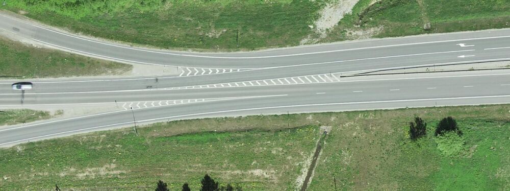
With increase of widespread availability of high definition imagery, it has become apparent that while clearly demarcated road areas that were not designed for regular traffic flow, such as highway shoulders, painted traffic separation areas or pedestrian crossing islands are now visible in detail sufficient for micromapping them as areas, there is no clear consensus on how to tag such places. Primary focus of this proposal is concentrated on often overlooked painted separator between roadways and ways to tag them as areas.
Quick survey using taginfo and Overpass revealed how those features are often tagged as area:highway=emergency. Problem is that such areas were often designed with controlled traffic flow being primary concern, not use in emergency situations and therefore value "emergency" does not best describe actual purpose of the feature. To make matters worse, clearest consensus on this matter seems to agree that since vehicles can physically travel across all lanes separated by barred areas (under certain traffic conditions), those linear highway segments should then be mapped as single linear highway feature as opposed to multiple roads (which would better describe legal movement under normal conditions).
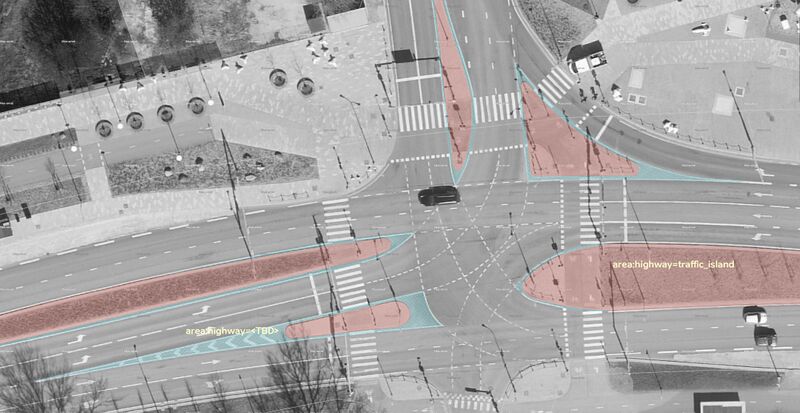
Therefore biggest changes introduced in this proposal are not just new tag for road area, but it would also have to redefine decision process if street needs to be mapped as single- or dual-carriageway. Due to introducing tagging for mapping painted dividers as areas, linear highway features should no longer ignore painted dividers and instead split when painted divider is mapped as area. Such resolution is conflicting with third paragraph of Dual_carriageway article: "Roads are not to be mapped as dual carriageways if the two directions are only separated /../ by paint". Using painted areas are often used for traffic control to direct vehicles away from upcoming physical barrier. Therefore it makes no sense to split linear highway=* feature as late as at end of pavement, because data consumers, such as navigation routers or self-driving cars may delay lane change until it's too late to legally change lanes. See screenshot below for example.
Another tag in use for such areas is area:highway=prohibited, which might be suitable for various types of marked areas not intended for (motorised) traffic.
PS: This proposal does not intend to challenge long stretches of (painted) flush median being mapped as single way, but it should be noted that major urban streets being redrawn as two one-way streets is natural evolution of OSM data detail level and should not be prohibited by rules based on region-specific generalizations made years (or even decades) ago.
Related wiki pages
Here's list of possibly related wiki pages. They were found using various search terms and all have been reviewed based on context of this proposal. Note that some similar articles are not listed here, because they focused on pedestrian traffic and/or didn't feature anything related to painted traffic islands.
- Dual_carriageway - This page defines requirements which can be conflicting with current idea. Namely painted barriers.
- Key:area:highway - Features many tag ideas for future use. Current wiki page lists area:highway=emergency as inconsistent and confusing tag due to lack of relation to emergencies. Talk-page of the key provides relatively up-to-date discussions on tag usage and calls for rewrite of tag definition. It's repeatedly pointed out that values of the tag should match values of highway=*.
- Original proposal suggested area:highway=emergency for exactly what this proposal is targeting, but it was suggested to be replaced by area:highway=barred_area or hatched area during original proposal's RFC.
- Key:road_marking - experimental tagging for mapping markings like lines, symbols or lane dividers (e.g. road_marking=solid_lane_divider, road_marking=gore_chevron)
- Key:crossing:island - Denotes traffic island on node where footway and street intersect.
- Key:crossing - Talk page contained many complaints over ambiguity of crossing=island, however one discussion pointed out how traffic islands are either between two crossings and therefore not suitable for crossing=* tag or they are not large enough and not suitable for OSM at all.
- Talk:Key:cycleway:buffer - While tag page itself is rather empty, talk page mentions existence of cycleway=buffered_lane and lane=buffered, where latter was used for buffer/separation zones between different lanes (not just bicycles).
- Key:divider - Has potential as additional tag, but is currently reserved for merely linear highway features.
- highway=footway/cycleway/path and *=island or *=traffic_island are primarily used for tagging portion of linear light traffic road (footway/cycleway) which is located on traffic islands. However, sometimes key is used on traffic island areas, but they are usually accompanied by area:highway=* tag with same value as highway=*
- Key:shoulder - Key for linear motorway/trunk features to tag shoulder presence.
- Key:traffic_calming - Some potentially useful tags other than regular traffic_calming=island, such as traffic_calming=chicane, traffic_calming=painted_island or traffic_calming=painted_table. Only notable talk page mention of islands defines them as an area raised higher than road surface.
- Talk:Proposed_features/area:highway - That's the first proposal to introduce area:highway=*, but it had no relevant suggestions worth mentioning in context of this proposal.
- Proposed features/area highway/mapping guidelines - Being created in 2015, it seems to complement Proposed_features/Street_area by providing many nice illustrative schematics, featuring area:highway=emergency and area:highway=traffic_island along with other similar area:highway=* tags.
- Proposed_features/separation#Symbolic_separation:_marking - Some examples for how to tag buffer zone between roadside cycleway and roadway, most notably cycleway:marking=barred_area.
- Proposed_features/Divided_road - Proposal from 2009 was panned during RFC due to major rework of highway mapping, but introduces some nice tagging examples that could be reused.
- Proposed_features/Divider - Divided road proposal was actually building on this proposal from 2007
- Proposed_features/Street_area Highly detailed proposal for general road area tagging, not just dividers. (Re-)introduced area:highway=*. Two main controversies of the proposal was suggesting area:highway=crossing for road junctions and area:highway=emergency for painted roadway dividers.
- Proposed_features/Traffic_island - Defined landuse=traffic_island as area containing kerbs, but didn't explicitly specify kerbs as it's boundary. Traversing pedestrian crossing was optional, however proposal suggested routing equivalence to pedestrian areas.
- Relations/Proposed/Area - Abandoned proposal which seems to have evolved into highway areas.
- Tag:area:highway=traffic_island - Redirects to street area proposal
- Tag:crossing=island - 9k uses for obsoleted crossing=island. Based on sample of central Europe, about 40% of crossing ways tagged as island were areas, many of them traffic islands.
- Tag:footway=traffic_island - Portion of pedestrian crossing that is located within traffic island.
- Tag:highway=crossing - Not much related to traffic islands other than that concerns about crossing way vs crossing node, that could be extended to crossing islands as well.
- Tag:highway=emergency_bay - Currently often mapped as node, but could be merged under subtag with same value.
- Tag:landuse=traffic_island - Now-abandoned tag introduced in traffic island proposal (~4400 uses)
- Tag:traffic_calming=island - Rather popular tag (~84k uses). Tag's main page does not provide any details about being used for painted areas. It does refer to Wikipedia page which also allows painted areas. Talk page discusses primarily dimensions requirements and concerns if traffic_calming=* is suitable key name considering not all islands' purposes aren't slowing the traffic down.
- Talk:Key:barrier#Traffic_Island - Traffic island as barrier was briefly discussed in 2010, but highway=* and landuse=* (landuse=street, landuse=highway) were suggested as more suitable.
- Traversable - Defines property (not tag) of traffic island for how easy is for car to travel across the surface.
- Seamarks/Colours#Colour_Patterns - Potential inspiration for tagging paint or maybe curb colour patterns
- landuse=highway & highway=traffic_island - mentioned on Talk:Tag:landuse=traffic island in 2011.
- Micromapping - Generic page for detailed mapping
Related tags
This section is reserved for taginfo-focused research.
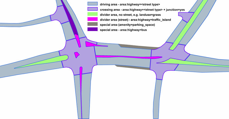
Illustrative example from Proposed_features/Street_area proposal. Current proposal's scope would cover just divider areas and special areas on the drawing.

Questionable parts
- Is it justified to put painted areas (hence traversable), areas surrounded by kerbs (such as pedestrian islands) and other non-traversable road areas (such as grass between dual carriageway) under same top level tag?
- What would be proper name for such area?
- If area:highway is primarily tag for renderers[1], then it won't make much sense develop it much further, especially when osm-carto ignores that key and renders area=yes+{tag|highway|service}} instead.
Tagging
Deprecate area:highway=emergency by renaming it to something more descriptive?
Additional tags:
- surface=*,
natural=* or landuse=*to describe material of the surface on which pattern is drawn. - divider=* - used on border of the area to describe if it's painted on road
- barrier=kerb - used on border of the area to describe if it's surrounded by kerbs.
Examples
Rendering
Features/Pages affected
External discussions
Thread in OSM World discord
Comments
Please comment on the discussion page.


