Proposal:Set of Traffic Signals
| Set of Traffic Signals | |
|---|---|
| Proposal status: | Abandoned (inactive) |
| Proposed by: | gypakk |
| Tagging: | amenity=traffic_signals |
| Applies to: | area |
| Definition: | to identify a joint set of traffic signals |
| Statistics: |
|
| Rendered as: | |
| Draft started: | |
| Proposed on: | 2008-06-27 |
Proposed new tag usage: Set of Traffic Signals
Rationale
The problem: At highway intersections with more than one node you normally have to tag every node with highway=traffic_signals. The renderer does not know if these traffic signals belong to one intersection. Maybe it paints one traffic signal icon, maybe it paints two or some more - in dependence of the present scale. Furthermore, navigation systems cannot suggest "Please turn right at the second intersection with traffic lights!" because they cannot determine if the second traffic_signals tag represents a separate intersection in reality.
Proposal
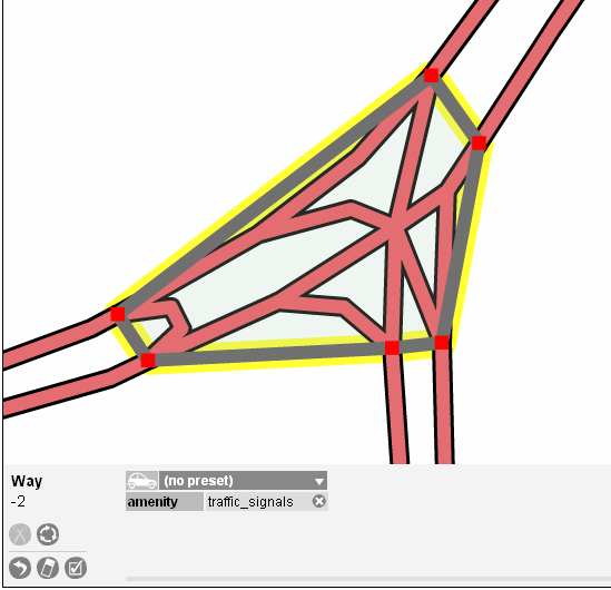
As a solution, I'd like to propose the usage of the special area tag to enclose every traffic signal belonging to one intersection. As a result the renderer knows that this is an intersection with a closed set of signals. Navigation systems can interpret this area as a homogeneous signal controlled intersection as well because the area shares its nodes with every inbound highway.
Examples
Every intersection which has traffic signals.
Tagging
Create an area around the intersection. Ensure that this area shares its nodes with every inbound highway, footway and cycleway. Ways with no traffic signal should not share a node with the area, of course.
Tag this area with amenity=traffic_signals
Applies to
This tag will be ignored if its node is shared with a traffic signal area.
Frequently used combinations
- traffic_signals:sound=yes/no
- traffic_signals:vibration=yes/no
- tactile_paving=yes/no/incorrect
Rendering
Display one traffic singal icon for each area described above. Position it to the center of the that area. You need not to draw the area itself.
This is already rendered by ...?
Comments
Please use the discussion page for comments.
Tenor of the Discussion
- Better use the relation tag for this.
- The relation tag is more complicated to handle than the proposed area.
- To draw the area you need lines which do not have a physical representation in reality. These lines can be confusing in the editor.
