Proposal:Lifts
| Elevators/Lifts | |
|---|---|
| Proposal status: | Inactive (inactive) |
| Proposed by: | Lulu-Ann |
| Tagging: | highway=elevator |
| Applies to: | |
| Definition: | A vertical public right-of-way for pedestrians |
| Statistics: |
|
| Rendered as: | |
| Draft started: | 2008-01-20 |
| RFC start: | 2009-04-24 |
Description
A public elevator (or lift) is used to travel vertically, providing passenger and freight access between pathways at different floor levels.
Example: the Golden Jubilee Bridges in London, have a lift at each end, allowing wheelchair access which would not otherwise be possible due to the steps used for normal access.
More examples of public elevators here
Mapping outdoor public elevators
Suggested mapping procedure: Add a node ![]() at the location of the elevator and add highway=elevator (c.f. highway=steps, which is also a physical description rather than a legal right-of-way type). For larger elevators, such as freight lifts, draw an enclosed way
at the location of the elevator and add highway=elevator (c.f. highway=steps, which is also a physical description rather than a legal right-of-way type). For larger elevators, such as freight lifts, draw an enclosed way ![]() around the outline of the lift. For non-vertical incline elevators, draw a straight way
around the outline of the lift. For non-vertical incline elevators, draw a straight way ![]() along the elevator's path.
along the elevator's path.
Connect highway=elevator with highway=footway or any other appropriate tag.
Note: Incline elevators should not be confused with longer-distance trams or aerial incline cable cars; continue to use railway=tram and aerialway=cable_car respectively.
Mapping indoor elevators
Elevators located within buildings could also be tagged as a property as building=* with elevator=yes if the specific location of the elevator(s) is unknown. If the specific location is known, adding the elevator, or multiple elevators, as separate nodes using the highway=elevator tag, would be the preferred approach (preferred level of detail to work towards). The number of floors should be specified on the features' building=* tag using building:levels=*.
Absence of an elevator
If there is no elevator, this could have negative consequences concerning the accessibility of a building for wheelchair users (if the building has more than one level). An absence of an elevator could be indicated by tagging elevator=no on the building=* tag or location node.
Access
Mostly pedestrians and definitely wheelchairs. Perhaps usable by bicycles. wheelchair=designated, foot=yes would be understood by default. Combine with access=* where appropriate.
Rendering
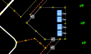
An elevator/lift icon ![]() would be used for the major map editors such as JOSM. The icon could also be rendered at the 18th zoom level in the slippy map. Large elevators mapped as an area
would be used for the major map editors such as JOSM. The icon could also be rendered at the 18th zoom level in the slippy map. Large elevators mapped as an area ![]() could be rendered with the icon combined with a light gray area similar to highway=footway, area=yes. Incline elevators would have a single icon with a grey way similar to railway=* tags.
could be rendered with the icon combined with a light gray area similar to highway=footway, area=yes. Incline elevators would have a single icon with a grey way similar to railway=* tags.
[ dead link ]
[ dead link ]
Tagging Examples & Description
| Example | Suggested Tagging |
|---|---|
| A Schindler-manufactured public elevator inside of a downtown office tower with Braille dots. |
|
| An employee elevator located somewhere inside of a supermarket. Specific location unknown. |
|
| A large non-public Otis freight elevator inside of a shopping mall. Location known. | |
| An outdoor Dover elevator with Braille. Elevator has English speech output. Location known. Bicycles ok. |
|
| An guest-only Schindler elevator inside of a hotel resort with Braille. Guest shows key to guard to access. |
|
