RU:OSM-3D
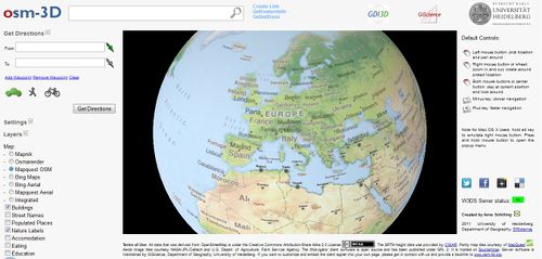
Проект OSM-3D.org направлен на предоставление интерактивного 3D-представления в Интернете по данным OpenStreetMap. В настоящее время он поддерживается
Гейдельбергским университетом, GIScience Group http://giscience.uni-hd.de. Он используется как демонстрационный пример, чтобы продемонстрировать потенциал 3D-карт, а также то, как 3D-инфраструктура пространственных данных (3D-SDI) может быть настроена с использованием стандартизованных и открытых интерфейсов. Отображение карты выходит за рамки простого отображения кешированных фрагментов, которые каким-то образом искажены, чтобы создать эффект перспективы. Он основан на модели графа сцены, которая включает в себя модель рельефа и множество функций OSM, которые мы могли бы обрабатывать. Этот график сцены можно изучить с помощью онлайн-просмотра XNavigator. Подготовка данных OSM для просмотра в OSM-3D требует много шагов предварительной обработки, которые выполняются на серверах GIScience.
Главная страница проекта: http://www.osm-3d.org
Доступность данных
Как следует из названия, все объекты карты импортируются из OSM. Мы попытались извлечь все важные функции, которые могут быть включены в общую универсальную 3D-карту. OSM не дает модели ландшафта, высоты данные были импортированы из другого источника. Модель возвышения получена из SRTM (Shuttle Radar Topography Mission), любезно предоставленной CGIAR. Он имеет разрешение ок. 90 м. CGIAR закрыл много пустот без данных, которые происходили в горных районах и на поверхностях воды с использованием методов интерполяции. Первоначальный набор данных SRTM не использовался для нашего пакета триангуляции местности, поскольку он основан на однородно распределенной точке. Области на полюсах от 60 N до 86 N и от 60 S до 86 S, где нет данных SRTM, заполнены данными GTOPO30, более грубым набором данных с разрешением ок. 1 км.
Местность доступна в виде прямоугольной плитки соответствия в системе координат сферических Меркатор от OpenStreetMap. Уровень 3-13 были полностью обработаны. Уровни 14-18, вычисляется по запросу и не кэшированы. Следовательно если вы посещаете место в первый раз это может занять немного больше времени для загрузки.
Здания и POI обрабатываются по всему миру и регулярно обновляются.
Объединенный набор данных OSM и SRTM перераспределяется как Web 3D Service (W3DS). W3DS - это сервис 3D-изображений, который в настоящее время обсуждается в Open Geospatial Consortium (OGC) как компонент для распределения геопространственных данных, закодированных в X3D, VRML, Collada, KML и других 3D-интернет-стандартах.
Он предназначен для создания ландшафтных и городских моделей, а также информационных слоев, таких как POI и метки. W3DS для проекта OSM-3D стал доступным как эталонная реализация для процесса стандартизации OGC. Более подробную информацию, тестовый клиент и документацию по интерфейсу можно найти на
http://www.w3ds.org/doku.php?id=osm-3d_w3ds
Map Features
Map Tiles
All tiles available in Mercator projection can be used. Currently the following styles are available:
- Mapnik
- Osmarender
- Mapquest
- Mapquest Open Aerial
- Integrated DEM Style
Здания
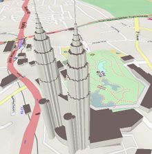
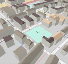
Здания представляют собой выдавленные плоские многогранники вместе с плоскими крышами. Высота основания интерполируется из DEM. В OSM здания моделируются либо способами, представляющими след в основании, либо как отношения, с внешним контуром и внутренними контуром зданий. Внутренние контур обрабатываются правильно, они отображаются в виде отверстий в многограннике. Наружные контура, состоящие из более чем одного способа, не могут быть обработаны. Нижняя и верхняя часть обычно плоские. Там, где доступна информация о крыше, алгоритм пытается восстановить геометрию крыши из типа крыши (например, gabled) и выравнивания. В некоторых случаях здания на крутых склонах вызывают проблемы, и части становятся висящими над землей. По этой причине стены не должны быть помечены как здания. В основном информация о высоте недоступна, поэтому нам нужно использовать фиксированное значение высоты с добавлением некоторого случайного отклонения. Если информация доступна, для построения геометрии здания используются следующие теги:
| Key | Description | Example values | Notes |
|---|---|---|---|
| height | Approximate height - distance from ground to roof of the building (Roof, not antenna or spire for skyscrapers by default) | By default : meter. For use in 3D apps
Includes well-known abbreviation of a length measure | |
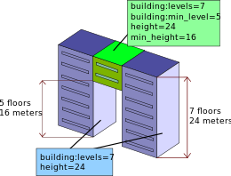
| min_height | Approximate height below the building structure | 31 m | Can be used to model complex building structures that have overhanging parts, or bridges. This value specifies the distance from ground to the lower edge of the building structure. The unit is meters unless otherwise specified. Note that when min_height is used, height is still defined as distance from ground to top of the structure. So "bridge" with 3 meters height, where bottom part of the bridge is positioned 100 meters above ground level will have height=103, min_height=100. |
| building:min_level | Number of stories between ground and actual first existing floor | 5 | For parts of building that are "floating in air" (actually, they are supported by other building parts that are fixed into ground), number of floors from ground that are not present. So if there is a passage under building, where 5 floors are missing, use building:min_level=5
Note that building:levels still counts floors from the ground, including also those nonexistent "skipped" floors, as can be seen in the explanatory picture number of levels is multiplied by 3 m to estimate the actual height |
| building:levels:aboveground | Number of stories of the building | 50 | number of levels is multiplied by 3 m to estimate the actual height |
| levels | Number of stories of the building | 50 | Same meaning as above. Number of levels is multiplied by 3 m to estimate the actual height |
Note: Some keys are used redundanty. Measurements in distance units (m, ft) are preferred over number of levels, which can be estimated with 3 meters each.
The order for parsing height keys is as follows: height, building:levels:aboveground, levels.
Please see Building_attributes for a reference of possible building attributes that could be very helpful in achieving realistic city models in the future.
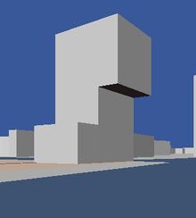
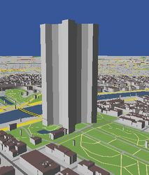
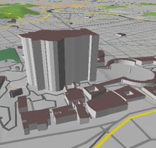
For large buildings is much better to divide them into multiple parts, each with a different height value. Otherwise, the groundplan is just extruded up the top level, which may look odd. Flat roof structures can be modeled very nicely using multiple rings of buildings (actually, this would be parts of a building and we should be looking a different key, but for now, we stick with building). Inclined roofs are not possible.
Good Examples:
Palace of Culture and Science, Warsaw, Poland. http://en.wikipedia.org/wiki/Palace_of_Culture_and_Science,_Warsaw.
Bad Examples:
Obviously there are many.
Eiffel Tower, Paris. Poor Tour Eiffel. Please see DE_talk:OSM-3D#Note_on_using_the_building_tag for comment.
Points of Interest
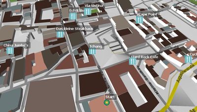
Points of Interest (POI) are displayed as 3D boxes with the symbol as texture and a text label. POIs are organized in the following layers:
- Money
- Public Facilities
- Health
- Shop
- Traffic
- Eating
- Enjoyment
- Education
- Public Transport
- Post
- Accomodation
Money
| Key | Value | Element | Rendering | Key | Value | Element | Rendering |
|---|---|---|---|---|---|---|---|
| amenity | atm | amenity | bank | ||||
| amenity | bureau_de_change |
This table is a wiki template with a default description in English. Editable here.
Public Facilities
| Key | Value | Element | Rendering | Key | Value | Element | Rendering |
|---|---|---|---|---|---|---|---|
| amenity | telephone | amenity | toilets | ||||
| amenity | courthouse | amenity | police | ||||
| amenity | public_building | amenity | townhall | ||||
| amenity | fire_station | amenity | place_of_worship | ||||
| tourism | information |
This table is a wiki template with a default description in English. Editable here.
Health
| Key | Value | Element | Rendering | Key | Value | Element | Rendering |
|---|---|---|---|---|---|---|---|
| amenity | hospital | amenity | pharmacy |
This table is a wiki template with a default description in English. Editable here.
Shop
| Key | Value | Element | Rendering | Key | Value | Element | Rendering |
|---|---|---|---|---|---|---|---|
| shop | supermarket | shop | bakery | ||||
| shop | butcher | shop | kiosk |
This table is a wiki template with a default description in English. Editable here.
Traffic
| Key | Value | Element | Rendering | Key | Value | Element | Rendering |
|---|---|---|---|---|---|---|---|
| amenity | fuel | amenity | parking |
This table is a wiki template with a default description in English. Editable here.
Eating
| Key | Value | Element | Rendering | Key | Value | Element | Rendering |
|---|---|---|---|---|---|---|---|
| amenity | fast_food | amenity | pub | ||||
| amenity | restaurant | amenity | biergarten | ||||
| amenity | cafe |
This table is a wiki template with a default description in English. Editable here.
Enjoyment
| Key | Value | Element | Rendering | Key | Value | Element | Rendering |
|---|---|---|---|---|---|---|---|
| amenity | cinema | amenity | theatre | ||||
| amenity | nightclub |
This table is a wiki template with a default description in English. Editable here.
Education
| Key | Value | Element | Rendering | Key | Value | Element | Rendering |
|---|---|---|---|---|---|---|---|
| amenity | university | amenity | school | ||||
| amenity | library | amenity | college |
This table is a wiki template with a default description in English. Editable here.
Public Transport
| Key | Value | Element | Rendering | Key | Value | Element | Rendering |
|---|---|---|---|---|---|---|---|
| highway | bus_stop | railway | tram_stop | ||||
| railway | tram | railway | subway_entrance | ||||
| railway | station | amenity | bus_station | ||||
| amenity | taxi |
This table is a wiki template with a default description in English. Editable here.
Post
| Key | Value | Element | Rendering | Key | Value | Element | Rendering |
|---|---|---|---|---|---|---|---|
| amenity | post_box |
|
amenity | post_office |
This table is a wiki template with a default description in English. Editable here.
Accomodation
| Key | Value | Element | Rendering | Key | Value | Element | Rendering |
|---|---|---|---|---|---|---|---|
| tourism | hotel | tourism | hostel | ||||
| tourism | motel | tourism | guest_house |
This table is a wiki template with a default description in English. Editable here.
Labels
Labels (POI) are displayed as 3D text objects. Labels are organized in the following layers:
- Suburb Labels
- Building Labels
- Building Numbers
- County Labels
- Locality Labels
- Village Labels
- Region Labels
- City Labels
- Nature Labels
- Street Labels
Suburb Labels
| Key | Value | Element | Rendering | Key | Value | Element | Rendering |
|---|---|---|---|---|---|---|---|
| place | suburb | place | airport |
This table is a wiki template with a default description in English. Editable here.
Building Labels
| Key | Value | logical operator | Key | Value | Element | Rendering |
|---|---|---|---|---|---|---|
| building | yes or true | AND | name | any |
This table is a wiki template with a default description in English. Editable here.
Building Numbers
| Key | Value | logical operator | Key | Value | Element | Rendering |
|---|---|---|---|---|---|---|
| building | yes or true | AND | addr:housenumber | any |
This table is a wiki template with a default description in English. Editable here.
County Labels
| Key | Value | Element | Rendering | Key | Value | Element | Rendering |
|---|---|---|---|---|---|---|---|
| place | county |
This table is a wiki template with a default description in English. Editable here.
Locality Labels
| Key | Value | Element | Rendering | Key | Value | Element | Rendering |
|---|---|---|---|---|---|---|---|
| place | locality |
This table is a wiki template with a default description in English. Editable here.
Village Labels
| Key | Value | Element | Rendering | Key | Value | Element | Rendering |
|---|---|---|---|---|---|---|---|
| place | village | place | hamlet |
This table is a wiki template with a default description in English. Editable here.
Region Labels
| Key | Value | Element | Rendering | Key | Value | Element | Rendering |
|---|---|---|---|---|---|---|---|
| place | region |
This table is a wiki template with a default description in English. Editable here.
City Labels
| Key | Value | Element | Rendering | Key | Value | Element | Rendering |
|---|---|---|---|---|---|---|---|
| place | city | place | town |
This table is a wiki template with a default description in English. Editable here.
Nature Labels
| Key | Value | Element | Rendering | Key | Value | Element | Rendering |
|---|---|---|---|---|---|---|---|
| natural | peak |
This table is a wiki template with a default description in English. Editable here.
Street Labels
Street Labels are created from the road network and displayed as separate layer. This layer is also tiled, i.e. labels are not provided as individual features, but as collection of features of a rectangular area. The font size depends on the tile level.
| Key | Value | Element | Font Size / Tile Level | |||||||||
|---|---|---|---|---|---|---|---|---|---|---|---|---|
| 16 | 15 | 14 | 13 | 12 | 11 | 10 | 9 | 8 | 7 | |||
| highway | motorway | 18 | 33.6 | 62.4 | 115.2 | 211.2 | 384 | 768 | 1536 | 3072 | ||
| highway | trunk | 12 | 24 | 48 | 96 | 192 | 384 | |||||
| highway | primary | 12 | 24 | 48 | 96 | 192 | ||||||
| highway | secondary | 12 | 24 | 48 | 96 | |||||||
| highway | tertiary | 12 | 24 | 48 | ||||||||
| highway | residential | 12 | 24 | |||||||||
| highway | living_street | 12 | 24 | |||||||||
| highway | service | 12 | 24 | |||||||||
| highway | pedestrian | 12 | 24 | |||||||||
| highway | footway | 12 | 24 | |||||||||
This table is a wiki template with a default description in English. Editable here.
Technical Facilities
Some man-made objects can be displayed as 3D symbol since they usually share a similar shape and color.
| Key | Value | Element | Rendering | Key | Value | Element | Rendering |
|---|---|---|---|---|---|---|---|
| man_made | lighthouse | man_made | windmill | ||||
| power_source | windgenerator |
This table is a wiki template with a default description in English. Editable here.
Функции Карты
Отображение и перемещение по карте не является единственной целью проекта OSM-3D. Не менее важны доступ к информации о функциях, поиск мест и маршрутов, импорт ваших собственных треков и другие взаимодействия с картой. Большинство из этих функций реализовано путем подключения к специализированным геобазам услугам с открытыми интерфейсами OGC. Использование служб OGC имеет то преимущество, что компоненты могут быть легко заменены, например, сторонняя OGC-служба, работающая с локальными данными, отличными от OSM, может быть подключена. Эти службы являются фактическими строительными блоками инфраструктуры пространственных данных. Однако обычно геоинформационные услуги предоставляют двумерные данные, например. геокодер обеспечит наиболее вероятные 2D-координаты. Для отображения вместе с моделью виртуального ландшафта высота должна быть получена из дополнительного источника. Для этой цели мы настроили службу запроса высоты (EQS), которая интерполирует значения высоты из DEM. EQS содержит базу данных PostGIS с триангулированными данными SRTM.
Следующие плагины доступны в xnavigator Webstart edition. Некоторые из них должны быть включены в меню панелей:
Получить Информацию о Функции
GetFeatureInfo-это операция W3DS. Вы можете нажать на карту и получите список атрибутов выбранного объекта.
Геокодер
Геокодер является распространенным компонентом в картографических приложениях. Она позволяет искать места и адреса. Обратный Геокодер получает координаты и ищет адрес в базе данных. Нажмите на здание и адрес появится.
Поиск POI
Удобная функция поиска точек интереса. Все POI OSM были классифицированы, пространственно индексированы и сохранены в базе данных PostGIS. Доступ к этой базе данных осуществляется через службу каталогов OGC. Панель поиска POI ("Желтые страницы") предлагает список всех доступных категорий и подтипов. Щелкните на карте, укажите радиус поиска, выберите категорию или один тип объектов, и вы увидите все близлежащие объекты POI, которые соответствуют вашему запросу. 3D-маршрутизация
Routing allows to find shortest or fastest connections between two points. The 3D route service (3DRS) is a special modification of the service used in OpenRouteService. It supports several modi: fastest route for cars, shortest route for cars, routes for pedestrians, and routes for bicycles. All these modes can be used in OSM-3D. The 3DRS delivers, in contrast to the normal RS, 3D line strings in the route description, which can be easier imported and displayed together with the DEM. You can either pick two arbitrary points, or specify addresses for the start and end point.
Импорт GPX
Если вы записали свои собственные GPS-треки, вы можете загрузить свои GPX-файлы и он отобразить в OSM-3D.
Доступ к данным датчиков
Данные датчиков могут быть получены в Службе наблюдения датчиков OGC (SOS). Отображение данных датчика включает в себя трехмерный символ, представляющий категорию датчика, и список значений, которые были недавно зарегистрированы датчиком. SOS содержит данные датчиков окружающей среды, собранные из другого источника.
OSM-3D Client Software
The web client that is used in OSM-3D is called XNavigator. It has been mainly developed as client for the W3DS reference implementation, but it also allows access to a couple of complementary OGC services. Hence it is sometimes also referred to as "integrated client", but in the OSM-3D project its main purpose is to fly through the city and landscape models without the need to install or configure anything.
XNavigator can be used in 3 ways:
- as Applet embedded in a webpage. This is the simplest version. Selection and configuration of layers is fixed and cannot be changed. Permalinks can be created and distributed. The Applet provides an External Authoring Interface (EAI) giving a limited access to internal functions. See OSM-3D Applet page for details.
- as Java Webstart. This gives you a complete GUI and full access to layers, settings, and map functionalities, including routing, geocoding, sensor data access and others. As additional navigation mode a 2D overview map can be used.
- as installation. Same as Webstart, but without restrictions. Webstart is running in a sandbox environment with limited access to system resources. With the installation you can also import models from your local hard drive. The installation is sometimes faster than Webstart, therefore it is the recommended version.
XNavigator homepage: http://xnavigator.sourceforge.net/doku.php
Обновления данных
It does not update anymore. --Henriko 11:48, 29 April 2011 (BST)
yes, we are doing updates: Buildings, POIs, labels etc. are updated approx. weekly or more often. But: Landuse & streets are only updated occasionally at the moment (very rarely) az 15. July 2011
Some Interesting Places
City of Rostock
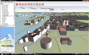
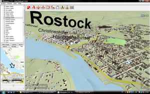
Первая полная модель города в OSM-3D была доступна для города Росток. В апреле 2009 года Управление по изучению земель (Kataster-, Vermessungs- und Liegenschaftsamt - KVL) Ростока пожертвовало все свои данные о строительстве в OSM. Следы здания были слегка упрощены и имеют точность <= 1 м, что достаточно для модели города LOD-1 (см. CityGML). По просьбе Боннского университета они также предоставили информацию о высоте здания, которую можно было импортировать в августе 2009 года. Для получения дополнительной информации об импорте данных см. Rostocker Gebäudehöhen Import 2009.
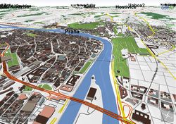
Скриншоты
more OSM-3D Screenshots
Servers
OSM-3D is running on several servers installed in the Computing Center of the University of Heidelberg (URZ).
| Server | Function | Configuration | System |
|---|---|---|---|
| rax | Application server
Proxy for internal services |
CPU: 2 x Intel Xeon X5355 @ 2.66GHz
HDD: 2 x 250GB SATA 7.2k in RAID 1 RAM: 16 GB |
Windows Server 2003 Enterprise x64 Edition
Java SE 6 Apache 2.2 HTTP Server Several Apache Tomcats |
| feldberg | Data processing server
Used for updates |
CPU: 2 x Intel E5440 @ 2.83GHz, Hyperthreading off
HDD: 2 x 300GB SAS RAM: 48 GB |
Ubuntu
PostGreSQL 8.4 Java SE 7 |
| zimba | Database server | CPU: Intel Core 2 Quad Q6700 @ 2.66GHz
HDD: 4 x 2TB SATA 5.4k. 3 of them in S/W RAID 0 RAM: 4 GB |
Debian Squeeze
PostGreSQL 8.4 |
| nebelhorn | Update server. Dedicated to building updates | CPU: Intel Pentium Dual-Core @ 2.50GHz
HDD: 250 GB RAM: 2 GB |
Windows XP
Java SE 6 |
This table is a wiki template with a default description in English. Editable here.
Statistics
As of 02/14/2012:
  Buildings: 50.043.209 / 76 GB
  Point Objects: 3.514.446 / 1GB
  Terrain Tiles: 68.562.212 / 398GB
  Total Database Size: 475GB
  Processing Database Size: 1425GB
As of 01/15/2011:
  Buildings: 23.262.900
  Point Objects: 5.659.070
  Terrain Tiles: 120.030.291 / 513GB
  Total Database Size: 572GB
  Processing Database Size: 1425GB
As of 07/20/2010:
  Buildings: 2.378.301
  Point Objects: 5.659.070
  W3DS Database Size: 99 GB
  Processing Database Size: 306 GB
Links
- OSM-3D_Applet
- Proposed_features/Building_attributes
- 3D_Development
- 3D_Development/Modelling
- 3D_Development/Tagging
- Indoor
- ProposedRoofLines
Внешние ссылки
- http://www.osm-3d.org
- OSM-3D in action: http://www.youtube.com/watch?v=TK85iSeLrGY
- http://srtm.csi.cgiar.org
- http://www.geog.uni-heidelberg.de/giscience.html
- http://www.w3ds.org
- http://xnavigator.sourceforge.net/doku.php
- http://sourceforge.net/projects/xnavigator/
| XNavigator | |
|---|---|
| Автор: | User:Aschilli |
| Лицензия: | GNU General Public License v2 |
| Платформа: | Java |
| Версия: | 1.4.1 (2012-02-26) |
| Языки: | немецкий и английский |
| Веб-сайт: | http://xnavigator.sourceforge.net/doku.php |
| Язык программирования: |
Java |
|
3D OSM viewer using SRTM DEM, Routing with OpenRouteService | |
