Reading
| V・T・E |
| latitude: 51.445, longitude: -0.9685 |
| Browse map of Reading 51°26′42.00″ N, 0°58′06.60″ W |
| Edit map |
|
External links:
|
| Use this template for your locality |
Reading is a town in Berkshire, South East England at latitude 51°26′42.00″ North, longitude 0°58′06.60″ West.
Events
There's a Missing Maps Mapathon held in Reading most months — keep an eye on the Events Calendar or the Facebook group for details!
Old Mapping Progress Notes
Reading is a unitary authority and borough in the South East England region. Together with the unitary authorities of Bracknell Forest, Slough, West Berkshire, Windsor and Maidenhead, and Wokingham it forms the ceremonial county of Berkshire.
The University town of Reading lies to the west of London, and to the south east of Oxford. The southern edge of the town is the M4 served by junctions 10, 11 and 12. The northern edge of the town proper is marked by the River Thames and the railway; north of the river is the suburb of Caversham, where the northern edge of the borough is indistinct, largely the edge of development. It collides with Wokingham in the south, with confusing political boundaries.
| Reading Borough Council (about) | 45% | 20% | Much of the "centre" of Reading was mapped over the mapping weekends. West Reading is almost untouched. |
|---|---|---|---|
| Wokingham Borough Council (about) | 10% | 5% | Due to the expansion of the suburban area without corresponding adjustment of borough boundaries, some areas of development commonly thought of as being in Reading (such as Shinfield and Earley) are in fact in the Wokingham Borough Council area. |
| Outlying villages (about) |
Reading Borough Council
The following areas are defined according to the Reading Borough Council wards.| Location | Tracklogs | Labelled maps | Notes |
|---|---|---|---|
| Abbey (about) | 95% | 95% | Around the civic centre and between Oxford Road & Chatham Street need work. |
| Battle (about) | 15% | 15% | Oxford Road, roads around the East edge and the NCR 5 done |
| Caversham (about) | 5% | 5% | Just the main roads |
| Church (about) | 90% | 90% | Only the South East tip needs doing |
| Katesgrove (about) | 99% | 99% | Pretty much complete. |
| Kentwood (about) | 5% | Most main roads traced | |
| Mapledurham (about) | 5% | 5% | A few roads done |
| Minster (about) | 40% | 40% | South of Berkeley Avenue and the rural area need doing. |
| Norcot (about) | 5% | Most main roads traced | |
| Park (about) | 100% | 80% | Very close to complete |
| Peppard (about) | Nothing much done | ||
| Redlands (about) | 90% | 90% | Very close to complete |
| Southcote (about) | 5% | Main roads are traced | |
| Thames (about) | 5% | {{{tags}}} | Some main roads done |
| Tilehurst (about) | 5% | Most main roads traced | |
| Whitley (about) | 70% | 70% | The North East is complete
|
Elsewhere
N.B. these could do with dividing up according to Wokingham Borough Council's wards, and/or some other scheme that makes it very clear which area roads lie in. A good distinction between parts of Earley and Shinfield would be helpful. Also a list of surrounding villages like Sonning.| Location | Tracklogs | Labelled maps | Notes |
|---|---|---|---|
| Woodley (about) | 25% | 10% | Some parts hugging the A329M are done. |
| Earley and Lower Earley (about) | 5% | 10% | All of the main roads are done, with some infilling along the A329. |
Please update this table if you add maps to the area, or if you notice missing areas from our coverage
See creating status pages for help editing these tables
Other pictures
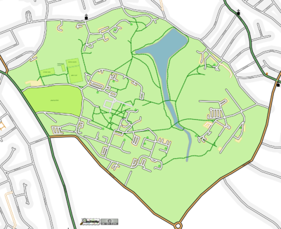
This is an Osmarender of Reading University's Whiteknights campus (as of prior to 2010-05), showing recycling facilities:
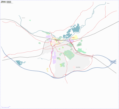
This is an Osmarender of Reading showing landuse areas and main roads (as of prior to 2010-05):
See also these maps of ethical locations in and around Reading, produced with OSM data.
Mapping Weekends
There was a Cloudmade sponsored mapping party 13 & 14 December 2008. See Reading Mapping Party 2008.
A group gathered on the 26th-28th August 2006 to map as much as possible.
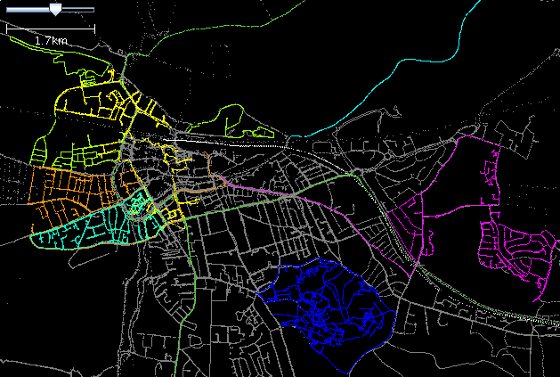
On the 15th-17th September 2006 Tom, Robert and Jamie got together to do some more mapping. The new traces are colourfully overlaid on the existing grey raw GPS data.


