Richmond-on-Thames Mapping Party 2007
The Fill The Gap Mapping Party 2007
June is the perfect time to get out of the smoke and enjoy the leafy suburbs of Richmond-on-Thames. The goal is to fill the gap between two extensively mapped areas and to complete the south-west of London from the centre all the way out to the M25.
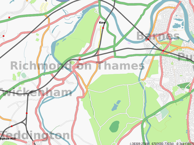
The primary target area is bounded by the River Thames to the west and Richmond Park to the east. We want to cover the town of Richmond on Thames and the surrounding areas of Kew, Mortlake, Sheen, Ham and, of-course, Kew Gardens and Richmond Park. And if all that gets done then there's plenty more virgin territory just across the river in Chiswick, Brentford and Twickenham.
When
The weekend of June 16/17, 2007.
Where
The Inn At Kew Gardens. It is two minutes walk from Kew Gardens railway station and has free wi-fi, an excellent range of beers, and a good choice of food. It's also a hotel, so accommodation is available for anyone travelling from afar.
Getting there
Richmond is easily reached by train from Waterloo or Reading, and the North London line. If you are coming by train aim for Kew Gardens railway/tube station. It's a two minute walk from the station. Route map here.
Note that the Richmond branch of the District line is suspended over the weekend.
Heathrow airport is just a few miles away for any overseas visitors.
The Inn at Kew Gardens is at lat: 51.4760 lon: -0.2871 for those who like to navigate by GPS.
Accommodation
The mapping party venue is also a hotel (Kew Gardens Hotel) with rooms costing about £85 per night, but there are other options including cheaper B&Bs nearby. The Richmond Tourism Site has an accommodation search engine where you can find lots of options. The following choices are all around £30 per night and not far from the mapping party venue:
Who
If you are new to OpenStreetMap then you can just turn up at the Inn at Kew Gardens at 10am on Saturday and/or Sunday where you will get a full briefing. A notepad or camera is the only thing that you need to bring. Everyone is welcome.
If you want to, you can help us with planning by adding you name to the list below. Please mention which days, what equipment you have and what mode of transport you will use:
- User:80n Saturday, Sunday / 2 x NaviGPS, Camera, Laptop / Bicycle
- User:Gravitystorm Sat + Sun / VentureCx, Camera / Bike
- User:Randomjunk Sat + Sun / NaviGPS, Camera, Laptop / Bike
- User:Morwen
- User:TomH Sat + Sun / PDA with GPS, Camera / Foot
- User:bleachin Staurday (need to confirm Sunday closer to date) NaviGPS, Garmin, Camera, Laptop on foot as bike has been nicked
- User:Steve
- Gregory TBC but I live very close. 1 x PDA/GPSr, Laptop, Camera Phone, Bicycle(or foot).
- User:JibberJim Sat + Sun Live in Kingston (just outside the region) Spare Room and floors for people to stay, also a spare bike if useful.
- User:NickwOn foot so Richmond Park or other green areas probably best.
- EAi Maybe, I live fairly close by. Got TomTom GPS+PDA and eTrex, Camera, Laptop, Bike
- User:marinheiro Maybe, I live in Hounslow and would like to help out in return for some mapping instruction to use in Hounslow later... Have garmin, bike, camera. Saturday only.
- User:Steve8 hopes to be there for one or other day. Have GPS and bike. TomH - if you are travelling each day do you want to share a car?
- Ojw and family.
- User:Firefishy Sat / Garmin, Camera, Bicycle
How
This area is ideal for surveying by bicycle, but the parks and riverside offer plenty of scope for walkers.
Yahoo! Aerial Imagery is available for this area so you can get started ahead of the mapping party by tracing all the visible water features, green spaces and land-use. Start Here
Saturday
- 10:00 Coffee and Bacon Sandwiches, planning
- 10:30 Out and about
- 12:30 Lunch
- 14:00 Out and about
- 17:00 Recap and beer
- 19:00 Dinner and more beer
Sunday
- 10:00 Coffee and Bacon Sandwiches
- 10:30 Out and about
- 12:30 Lunch
- 14:00 Out and about
- 17:00 Wrap up
Cake
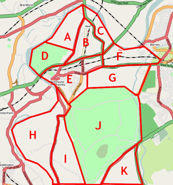
The cake to the right shows the target area cut up into nice ready to eat slices. If you fancy a particular area please add your name against the appropriate letter below:
| Sector | Who | Status | Notes |
|---|---|---|---|
| A - Kew Gardens | Abi, Rowan | - | £12.25 day, multi-entry [1], 20% off voucher, No bicycles |
| B - Kew Village | Ojw and 80n | Completely surveyed | |
| C - Kew Riverside | User:80n | Completely Surveyed | |
| D - The Old Deer Park | Tom | - | |
| E - Richmond Town Centre | I'm actively surveying area E on weekday evenings already User:Tialaramex | - | |
| F - Mortlake | Dave, Mike | - | |
| G - Sheen | Andy | - | |
| H - Ham and Petersham | Grant (Saturday) and Steve8 (Sunday) | - | |
| I - North Kingston | Ojw Sunday | - | |
| J - Richmond Park | User:Nickw, probably best as on foot | Partially done, more tomorrow. | |
| K - Kingston Hill and Kingston Vale | Steve, Rhys | - | |
| Chiswick | Graham | - | |
| Off-cake - West of the river | Gregory, will state a detailed area if anyone wants off-cake too. | - |
Results
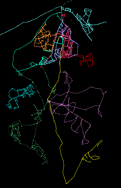
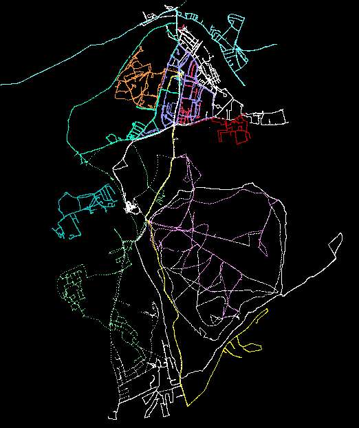
Day one on the left. Both day one and day two on the right.
What to Bring
- A GPS unit if you have one. OSM's own GPS units will be available for loan to anyone that does not have one (photo-id or credit card required as a deposit).
- A camera, or dictaphone or pencil/paper for recording street names, etc.
- A bicycle, if you have one.
- A laptop, if you want to upload your data and work on it over the weekend.


