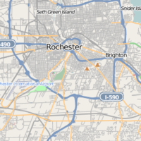
Rochester, New York
| V・T・E |
| latitude: 43.15621, longitude: -77.61044 |
| Browse map of Rochester 43°09′22.36″ N, 77°36′37.58″ W |
| Edit map |

|
|
External links:
|
| Use this template for your locality |
Rochester is a City in New York at latitude 43°09′22.36″ North, longitude 77°36′37.58″ West.
This page refers to the city in New York. For other uses, see Rochester (disambiguation).
Events
Richard Weait introduced OSM to the Linux User Group of Rochester during their regular monthly meeting, April 16th, 2009, at RIT. Previously, he had visited Barnaby Bienkowski in Rochester to do some mapping, and several LUGOR participants had attended an OSM presentation at the 2008 Ontario Linux Fest.
Progress Mapping Rochester
Highways
As of DATE - 20090427 TIGER data is available for most streets and highways in Rochester.
Bikeways
As of DATE -
Parks
As of DATE - 20090427 User:Deejoe uploaded edits of and a trace made on 20090426 of the footpaths in the northeastern-most section of Highland Park, correcting a significant error in the TIGR data for the path of Pinetum Rd.
Still Needed:
Rochester and the broader region still can use significant work.
- Checking and correcting existing TIGER data.
- Completing the Erie Canal, which now only runs on OSM from Pittsford to Spencerport, instead of from Albany to Buffalo.
- Including bicycle and footpaths such as
- Lehigh Valley trail
- Genesee Riverway trail
- Including paths and features of our many parks, including
- the Frederick Law Olmstead parks
- Highland Park
- Genesee Valley Park
- Seneca Park (including the zoo)
- Black Creek Park
- Powder Mill County Park
- Durand Eastman Park
- Updating for recent developments such as
- Park Point at Jefferson Road at John St in Henrietta
- Brooks Landing Project across the Genesse from the University of Rochester at the east end of Brooks Avenue
Water
Many ponds and waterways are missing from OSM, including (but definitely not limited to):
- Ponds near Braddock Bay
- Long Pond
- Cranberry Pond
- Long Pond
- Buck Pond
- Many small creeks and ponds