Tag:service=parking aisle: Difference between revisions
Jump to navigation
Jump to search
How to Map
(switch to a Mapnik rendering example and moved it to the rendering section) |
Polarbear w (talk | contribs) m (disambiguation) |
||
| (One intermediate revision by the same user not shown) | |||
| Line 3: | Line 3: | ||
value=parking_aisle| |
value=parking_aisle| |
||
image=Image:Parking_aisle.jpg| |
image=Image:Parking_aisle.jpg| |
||
description=A parking aisle is |
description=A parking aisle is a subordinated way in a parking lot between rows of parking spaces that vehicles use to drive into and out of the spaces.| |
||
onNode=no| |
onNode=no| |
||
onWay=yes| |
onWay=yes| |
||
| Line 13: | Line 13: | ||
==How to Map [[Image:Mf_way.svg]]== |
==How to Map [[Image:Mf_way.svg]]== |
||
In an area with {{Tag|amenity|parking}} add these (often multiple) subordinated ways that allow access to the rows of parking spots with both<br>{{Tag|highway|service}} and<br>{{Tag|service|parking_aisle}}.<br> |
|||
Add a {{Tag|oneway}} tag if appropriate. |
Add a {{Tag|oneway}} tag if appropriate.<br> |
||
The main way(s) on the parking lot, for entering and connecting multiple parking_aisle, should be mapped with {{Tag|highway|service}}, only. |
|||
<br clear="left" /> |
<br clear="left" /> |
||
==Disambiguation== |
|||
A driveway onto a residential or commercial property, even if there are a small number of parking spots, should still be tagged {{Tag|highway|service}} and {{Tag|service|driveway}}, and not as parking_aisle. |
|||
== Rendering == |
== Rendering == |
||
| Line 29: | Line 34: | ||
*[[Approved features/service=parking aisle|Proposal of this feature]] |
*[[Approved features/service=parking aisle|Proposal of this feature]] |
||
Related terms: {{RelatedTerm|parking |
Related terms: {{RelatedTerm|parking}} |
||
Revision as of 13:26, 10 July 2014
| Description |
|---|
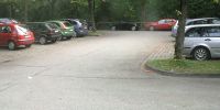
| A parking aisle is a subordinated way in a parking lot between rows of parking spaces that vehicles use to drive into and out of the spaces. |
| Rendering in OSM Carto |

|
| Group: highways |
| Used on these elements |
| Requires |
| Useful combination |
| Status: approved |
| Tools for this tag |
|
How to Map 
In an area with amenity=parking add these (often multiple) subordinated ways that allow access to the rows of parking spots with both
highway=service and
service=parking_aisle.
Add a oneway=* tag if appropriate.
The main way(s) on the parking lot, for entering and connecting multiple parking_aisle, should be mapped with highway=service, only.
Disambiguation
A driveway onto a residential or commercial property, even if there are a small number of parking spots, should still be tagged highway=service and service=driveway, and not as parking_aisle.
Rendering
Width is thinner than a highway=service roads.
Viewable only at zoom levels 16, 17, 18 in Mapnik; 15, 16, 17 in Osmarender.
See Also
- amenity=parking
- Parking
- barrier=* Are there fences/stones hindering free roaming on an empty parking area?
- Proposal of this feature
Related terms: ‹ parking ›

