Uploads by Gregrs
Jump to navigation
Jump to search
This special page shows all uploaded files.
| Date | Name | Thumbnail | Size | Description | Versions |
|---|---|---|---|---|---|
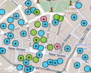
| 19:37, 11 April 2021 | FHODOT.png (file) |  |
278 KB | Screenshot of FHODOT, the food hygiene open data OpenStreetMap tool https://gregrs.dev.openstreetmap.org/fhodot/ OpenStreetMap data © OpenStreetMap contributors. Food hygiene rating data licenced under the Open Government Licence (OGL) by the Food Standards Agency. © Crown copyright and database right. | 1 |
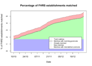
| 14:20, 10 August 2017 | 2016-Q4-project-progress.png (file) |  |
109 KB | 1 | |
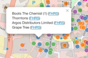
| 14:07, 10 August 2017 | FHRS-OSM comparison tool.png (file) |  |
73 KB | 1 | |
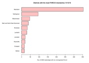
| 20:26, 14 October 2016 | Id-mismatches.pdf (file) |  |
5 KB | Bar plot showing the districts with the most nodes/ways with an unrecognised fhrs:id | 1 |
| 12:26, 30 August 2016 | OSM vs OS trig stations histogram.pdf (file) |  |
5 KB | Histogram showing distance between OSM man_made=survey_points and nearest OS triangulation stations as of August 2016 Produced using [https://www.r-project.org/ R] © OpenStreetMap contributors<br> Contains public sector information licensed under th... | 1 |
| 12:17, 30 August 2016 | QGIS default vs OSTN02 map.pdf (file) |  |
593 KB | Comparison between the default transformation used by QGIS 2.8 to convert between WGS84 and British National Grid with the [https://www.ordnancesurvey.co.uk/business-and-government/help-and-support/navigation-technology/os-net/ostn02-ntv2-format.ht... | 1 |
| 12:09, 30 August 2016 | OSM vs OS trig stations map.pdf (file) |  |
4.74 MB | Comparison map between OpenStreetMap man_made=survey_points and Ordnance Survey triangulation stations in Britain as of August 2016. © OpenStreetMap contributors Contains public sector information licensed under the Open Government Licence v3.0 | 1 |