Proposal:Rivers
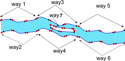
This is a proposal for a Relation to group the opposite banks of a wide river.
The relationship is intended to define the area of the river, to enable it to be rendered as a filled area.
This relationship is intended in part as a hint to renderers that the adjacent ways are actually part of the same river so the name could be positioned between the riverbanks.
Example
Relationship A has members: way 1 (role:outer) & way 2(role:outer); Relationship B has members: way 3(role:outer), way 4(role:outer) & way 7(role:inner) ; Relationship C has members: way 5(role:outer) and way 6(role:outer);
Also possibly a Relationship D which has members : Relations A , B & C. Though I'm not sure in practice how possible this would be, (ie collecting all the relations of one river along the whole length together) as the distance the individual relations could be spread apart is very large, and editing that relation D could be a nightmare.
Ways to edit rivers
- a single way
- multiple areas
- two ways, depicting the banks.
- two sets of ways which together comprise the opposite banks
