Tag:highway=track
| Description |
|---|
| A minor land-access road like a farm or forest track. |
| Rendering in OSM Carto |

|
| Group: highways |
| Used on these elements |
| Useful combination |
| See also |
| Status: de facto |
| Tools for this tag |
|
The tag highway=track is used for minor land-access roads that are not considered part of the general-purpose road network [1]. Track roads are mostly used for agriculture, forestry, outdoor recreation, and similar activities on open land. Roads used for access to permanent human settlements or facilities should generally not use this tag. Track roads are used by four-wheeled (two-track) vehicles and often take the form of two wheel tracks in the ground (also known as a two-track road), but they may also be graded or paved in some regions.
How to decide
Some examples where highway=track is generally not appropriate:
- A road that is minor but serves as a connection in the general-purpose road network. See highway=unclassified.
- A minor road with permanent residences along it. See highway=residential.
- A minor road providing primary access to one or several permanent residences (driveway). See highway=service.
- A minor road providing primary access to a commercial or industrial facility. See highway=service.
- A trail or path that is not wide enough for a typical four-wheeled motor vehicle [2]. See highway=path, footway, cycleway, and bridleway.
If none of the above are true for a road, and its primary use is access to the surrounding land, highway=track is likely appropriate. Some examples:
- A farm track used for access to crop fields, pastures, orchards or similar agricultural land.
- A forest road used for outdoor recreation, logging, or other forestry purposes (aka, forest track, woods road, logging road)
- A fire road used for fighting wildfires in grassland, scrubland, and forestland.
- A minor road used for access to conservation land.
- A dirt track used for access to the mountains, desert, or other remote area.
This list is non-exhaustive and highway=track is also appropriate in many other land access situations. Track roads may also access minor structures on the land such as hunting cabins, fire lookouts, agricultural service buildings, or camping shelters. As long as the primary purpose of the road is land access, highway=track is appropriate.
How to map
To map a track road, create a way ![]() and add the tag highway=track. Add a name=* and/or ref=* if the track has a name, reference number, or code.
and add the tag highway=track. Add a name=* and/or ref=* if the track has a name, reference number, or code.
Physical condition
Define the physical attributes of a track road with these supporting tags:
- surface=* specifies the surface material (paved, unpaved, gravel, dirt, etc).
- tracktype=<grade1-grade5> specifies roadway firmness.
- smoothness=* specifies physical usability by different types of wheeled vehicles.
- width=* specifies the width of the track.
Without these tags, the only thing highway=track implies about vehicle suitability is that the way is wide enough for a typical four-wheeled (two-track) vehicle. While some track roads are passable in an average passenger car, others require high clearance, or an off-road vehicle. Vehicle widths also vary. So adding these supporting tags is recommended if the information is available.
Access
highway=track does not imply any particular access=* value. Default access restrictions are country specific and depend on ownership, land use and other factors. If you have local knowledge or can do a survey to obtain ground truth, adding explicit access tags is recommended.
Broader interpretations & existing usage
For a variety of reasons highway=track has been interpreted more broadly at times. Because of this, there are areas where ways currently tagged as highway=track may be better represented by a different highway=* classification combined with supporting tags.
| Interpretation | Why it’s too broad | Recommended supporting tags |
|---|---|---|
| Dirt or unpaved road | Unpaved roads are common in many regions and the majority are not track roads. The surface material of a road is not enough information to classify it. | surface=unpaved, surface=dirt, or other surface=* value |
| Road requiring a rugged vehicle (high clearance or off-road capable) [3] | Not all track roads require a rugged vehicle, and not all roads requiring a rugged vehicle are track roads. In some regions this requirement can be a strong hint that track is the appropriate classification. However, it is not sufficient for a worldwide definition. | smoothness=<very_bad-very_horrible>
tracktype=<grade3-grade5> |
| Rarely used or abandoned road | Many track roads do fit this description, but many others do not. For an old road that is now only used by pedestrians, bicycles, and/or horses, highway=path may be a better choice. For an overgrown track which is hard to pass, consider obstacle=vegetation. For a completely unused and abandoned road, a lifecycle prefix may be a better choice. | disused:highway=*, or abandoned:highway=*
obstacle=vegetation smoothness=<horrible-impassable> tracktype=<grade4-grade5> |
highway=track has also been used for access roads in cemeteries, parks, allotment gardens, golf courses, and recreation grounds. This usage may be considered appropriate by mappers in some regions, but in many others highway=service is recommended instead.
Examples that may be track roads
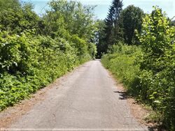
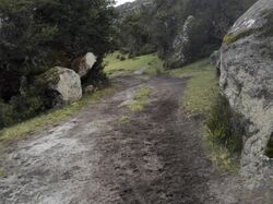
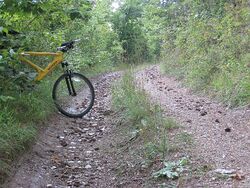
Here are some examples of how track roads can look. Please note that highway=track should be chosen based on function (see How to decide), not simply because a road looks like one of these examples.
These three examples look like typical forest access roads in many regions. If that is in fact their primary use, highway=track is appropriate. However, driveways or even rural public roads can look like this as well. In those cases a different highway=* classification should be used.
These three roads are fairly rugged. They likely only provide access to the forest or mountains, meaning highway=track is appropriate. However, in some regions of the world roads like these may connect settlements and be considered part of the general-purpose road network. In this case, a different highway=* classification would likely be more appropriate. Always make sure you are familiar with local mapping conventions.
These three examples look like various types of farm tracks for access to fields. This is a common use case for highway=track. It’s unlikely the grassy track is used for anything other than pasture access, but the other two could potentially be driveways. The paved one could even be a public road just passing by farm fields. In either of those cases a different highway=* classification should be used.
Unpaved roads that are not track roads
Other kinds of tracks
- Track for other kinds of tracks, or more specifically:
Access implications
Note that while for example in many parts of Germany and all of Poland highway=track without access tags can be assumed to be accessible, in the UK this should not be assumed.
External discussions
The meaning of this tag and its documentation was discussed at length in early 2021 on the talk page and on these mailing list threads.
- 2021-02 - [Talk-us] Usage of highway=track in the United States
- 2021-02 - [Tagging] Use of highway=track vs highway=service cemeteries, parks, allotment gardens, golf courses, and recreation areas
- 2021-03 - [Tagging] Proposed rewrite Of highway=track wiki page
- 2021-04 - [Tagging] Proposed rewrite Of highway=track wiki page - Third Draft
Footnotes
- ↑ The "general-purpose road network" consists of unclassified, tertiary, and higher road classifications. Track roads are mostly not for general motor vehicle traffic, but are used by some subset. So these ways are seen as something a bit less than a road and not really part of this general-purpose road network.
- ↑ A "typical four-wheeled motor vehicle" means a general purpose or average motor vehicle commonly used in a given region. The size and capability of what is considered a typical, common, or average vehicle varies around the world.
- ↑ The 2007 TIGER import assigned highway=track to US Census Bureau Feature Class Code (CFCC) A51: "Vehicular trail, road passable only by 4WD vehicle, unseparated".
| ||||||||||||||||||||||||||||||


