Tag:highway=steps
| Description |
|---|
| For flights of steps on footways and paths. |
| Rendering in OSM Carto |

|
| Group: highways |
| Used on these elements |
| Implies |
| Useful combination |
|
| See also |
| Status: de facto |
| Tools for this tag |
|
For flights of steps on footways and paths.
How to map
Add a way ![]() along the length of the steps with the tag highway=steps on it. If known, use incline=up when the direction of the way points upwards or use incline=down respectively.
along the length of the steps with the tag highway=steps on it. If known, use incline=up when the direction of the way points upwards or use incline=down respectively.
For areas ![]() use also area:highway=steps
use also area:highway=steps
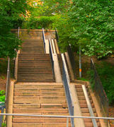
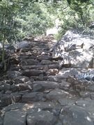
Consider splitting long steps (see examples in gallery) into sections for each flight of steps with the landing between each flight as highway=footway as this provides better information for those who might find a long flight of steps too much to climb in one go. Wikipedia ![]() Stairs has a good section on terminology of parts of steps and stairs.
Stairs has a good section on terminology of parts of steps and stairs.
Useful Information
Steps outdoors are these days constructed to specific standards (for instance British Standard 5395), and knowing some basics about relevant local standards can assist in collecting information. For instance highway footbridges in the UK have the following limits : risers <= 15 cm; going >= 30 cm; number of steps (risers) in a flight <=13. Source: Footbridge Design Guide CD 353, on the other hand there are still many historic examples built according to different standards and occasionally new works don’t correspond to the actual requirements, so don’t blindly rely on current legislation.
Tags to use in combination
- step_count=* can be added to indicate the number of steps, useful especially for cases where number of steps is low and sparse. It indicates in such cases that steps are less significant obstacle than indicated just by their length.
- handrail=* can be used to specify where the handrail is located.
- tactile_paving=yes/(no)/incorrect if there is a paving on both ends of the steps that can be found with a blind person's stick.
- tactile_writing=yes/no indicates whether there is tactile writing available at the handrail(s) of the steps.
- Note: If the handrail(s) is/are mapped separately with barrier=handrail, the key should be added on to this feature.
- Note: If possible, the type of tactile writing which is available should always be specified, for example with tactile_writing:braille:xx=yes, where xx is a language code, for example en for English, see tactile_writing=* for details.
- surface=* indicates the surface.
- ramp=* indicates whether a ramp is available.
- level=* the floor levels connected or passed through by the stairs (e.g. at stations)
- level=0;1 between the ground floor and the 1st floor
- width=* width in meters
- name=* add if the steps have a special name
- flat_steps=* a tag to express that the steps are actually flat enough to be driven on (e.g. 1 step every meter)
- platform_lift=* - indicates the availability of platform lift for wheelchair users, worth adding if such platform, is present
- Do not use access=yes (it applies to all transport modes), if you want to tag steps as generally accessible to pedestrians the best solution is to not set any access tags.
Escalator
highway=steps + conveying=yes/forward/backward/reversible
You can also specify the direction of the escalator: incline=up/down. See conveying=* for details.
Examples
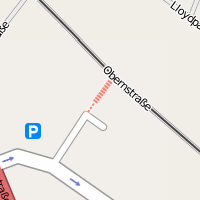
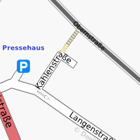
Following examples are with full steps-specific tagging. There are also other tags such as surface=*, lit=* etc not mentioned here. It is also fine to tag just highway=steps and leave detail for others.
Rendering examples
Possible tagging mistakes
See also
- Proposed features/Access Ramp is a proposal for tagging independent ramps from 2008-03-06
- Proposed features/Steps features for additional tags describing steps from 2009-04-23 (some of these tags are in common use by now, some are replaced by others)
- Relations/Proposed/Area#Area-steps is a proposal for mapping area steps from 2009-12-02
- Stairs modelling some ideas regarding 3D modelling (and improvements for the 2D rendering of more complex cases of stairs) from 2014
- Proposed features/Area-steps is a proposal for mapping area steps from 2015-03-04
- MENTZ GmbH – proposals for indoor modelling of steps (first version from 2016)
- area:highway=steps – An area representation of a highway=steps which is separately mapped with a linear way.
- highway=ladder – A ladder.
- ladder=* – This tag indicates the presence of a ladder (as a property).
- Guidelines for pedestrian navigation
| ||||||||||||||||||||||||||||||


