Tag:barrier=berm
| Description |
|---|
| A berm is a level space, shelf, or raised barrier (usually made of compacted soil) separating two areas. |
| Group: barriers |
| Used on these elements |
| See also |
| Status: in use |
| Tools for this tag |
|
Proposal
A ![]() Berm is a level space, shelf, or raised barrier (usually made of compacted soil) separating two areas. It can serve as a fortification line, a border/separation barrier, in industrial settings, or in many other applications.
Berm is a level space, shelf, or raised barrier (usually made of compacted soil) separating two areas. It can serve as a fortification line, a border/separation barrier, in industrial settings, or in many other applications.
This feature is more commonly mapped with man_made=dyke or man_made=embankment
Description
There are several uses for berms, including as:
Military use
In medieval military engineering, a berm (or berme) was a level space between a parapet or defensive wall and an adjacent steep-walled ditch or moat.
During World War I trench warfare, the name was applied to a similar feature at the lip of a trench, which served mainly as an elbow-rest for riflemen.
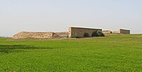
In modern military engineering, a berm is an earthen, or sod, wall or parapet. Walls constructed in this manner are an effective obstacle to vehicles, including most armoured fighting vehicles, but are easily crossed by infantry. Because of the ease of construction, such walls can be made hundreds or thousands of kilometres long.
A prominent example of such a berm is the 2,700 km (1,700 mi) ![]() Moroccan Western Sahara Wall.
Moroccan Western Sahara Wall.
Berms are also commonly used to surround explosives, or ammunition, storage depots, so as to direct the force of any explosion harmlessly upwards, rather then outwards at ground-level.
Another similar use for them is to surround parked aircraft, both to provide protection to ground personnel in case of the aircraft exploding, & also to protect the aircraft from the explosion of nearby bombs.
Erosion control
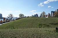
Berms are also used to control erosion and sedimentation by reducing the rate of surface run-off. The berms either reduce the velocity of the water, or direct water to areas that are not susceptible to erosion.
Noise control
In modern highway construction, a berm is a noise barrier constructed of earth, often landscaped, running along a highway to protect adjacent land users from noise pollution.
Pollution control
Berms are also used as a method of environmental spill containment and liquid spill control. Bunding is the construction of a secondary impermeable barrier around and beneath storage or processing plant, sufficient to contain the plant's volume after a spill. This is often achieved on large sites by surrounding the plant with a berm.
Shooting ranges
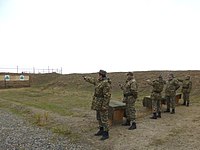
Berms are also used as protection around open-air shooting ranges, to prevent fired projectiles from leaving the range boundary. They can be used either as a backstop, behind the targets, or to separate groups of shooters.
How to map
Depending on the width of the berm, it can be mapped either as a simple line, drawn along the centreline of the wall; or as an area enclosing the outer boundaries of the wall.
Tags used in combination
Similar tags
- man_made=dyke for a dyke or levee
- man_made=embankment for a raised bank to carry a road, railway, or the like.
- barrier=retaining_wall for a structure that holds back soil or rock from a building, structure or area.
- barrier=debris when a road is blocked by debris.
External discussion
- Tagging mailing list:https://lists.openstreetmap.org/pipermail/tagging/2019-November/049404.html


