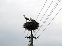
Tag:birds_nest=stork
| Description |
|---|
| Stork's nest |
| Group: natural |
| Used on these elements |
| Useful combination |
| Status: de facto |
| Tools for this tag |
|
Stork's nest. Note that mapping nesting places of nearly all birds is discouraged as this information tends to change quickly, is hard to verify and mapping it may easily lead to causing trouble for birds.
Storks are unlike many other birds, with nests typically in a prominent and clearly visible places, staying in the same location for many years and well known to people.
Therefore, mapping nests of storks is without problems that may result from mapping nesting locations that are kept secret to protect species.
It is also a long-term object, staying for many years and relatively easy to survey and identify due to its size and typically prominent location and without verifiability issues.
Tagging
Power pole with storks nest and nest platform may be tagged: power=pole + natural=birds_nest + birds_nest=stork + nest_platform=yes

