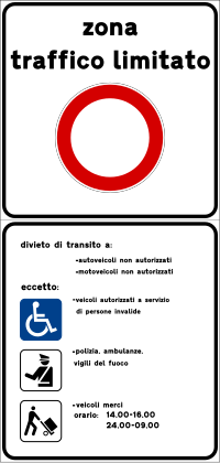
Tag:boundary=limited_traffic_zone
| Description |
|---|
| An area that requires authorization for the entry of certain vehicles, sometimes for specific periods. |
| Group: boundaries |
| Used on these elements |
| Useful combination |
|
| See also |
| Status: in use |
| Tools for this tag |
|
A limited traffic zone (LTZ) is an officially designated area that requires authorization for the entry of certain vehicles, sometimes for specific periods. It is related to, but distinct from, boundary=low_emission_zone (LEZ). About 350 Italian cities have LTZs, and 250 have LEZs. Although not as numerous, LTZs also exist in Spain, Portugal, France and Poland.
Nominatim supports these areas when given a name=*. Mapping these areas does not affect rendering nor routing.
Country-specific information
Italy
| Name | Active since | Limitations | Status | Link | Last Update | Notes |
|---|---|---|---|---|---|---|
| Cagliari | Marina Castello Villanova Stampace Alto Stampace Basso Poetto |
|||||
| Milano | Area B Area C |
|||||
| Modena | ZTL |
|||||
| Monza | ZTL |
|||||
| Palermo | Centrale |
|||||
| Reggio Emilia | ZTL |
|||||
| Riva del Garda | ZTL |
|||||
| Roma | ZTL |
Access restrictions on ways
It is recommended to detail the access restrictions on the affected ways. Some important things to note:
- Ground signage may indicate that different restrictions apply to different ways within the same zone.
- Use vehicle=*, as access=* applies to all modes of transport, including pedestrians, for which such restrictions do not apply.
- Use vehicle=permit unless an access permit is not routinely granted to almost everyone requesting it; in this case, use vehicle=private.
- Use motor_vehicle=permit and moped=yes if access is restricted only to autoveicoli and motoveicoli, as those two categories encompass almost all motor vehicles except for mopeds.[note 1]
- Use bicycle=dismount to allow correct routing unless cycling is allowed.[note 2]
- City legislation may establish permissions that are not explicitly stated on signs and that can be mapped, for example, psv=yes and bicycle=yes.
- It is sometimes necessary to change highway=* if the way is not normally open to most vehicles and does not have the normal design of a street built for traffic, normally to highway=pedestrian, as highways should be classified according to their intended main use.
| Sign | Tags on ways |
|---|---|

|
|

|
|

|
|

|
|

|
|

|
|
Surveillance cameras
When surveying these areas, it may be interesting to observe the position of the zone's access surveillance cameras, usually located close to the access restriction signs, and add them to the map as points with man_made=surveillance + surveillance=public + surveillance:type=camera + surveillance:zone=traffic + camera:type=fixed + camera:mount=pole or similar. Furthermore, the watched point and direction can be represented using an enforcement relation with enforcement=access.
Notes
- ↑ trolleybuses, agricultural machinery, snowplows and construction machinery are not part of them either
- ↑ A controversial and politically charged subject in Italy, articles 47(1.c) and 3(1.54) of the Italian Traffic Code define bicycles as vehicles and ZTLs as areas where vehicle movement is limited (hence the use of the "no vehicles" sign), but article 3(1.2) allows cycling in pedestrian areas. This contrast seems to cause confusion in the interpretation of the law and lead some local administrations to make prohibition explicit in the signage, while permission is usually indicated on the standard panel listing exempt vehicle categories.
- ↑ Permit is generally not required when the way is likely to be traveled, only outside of busy times.
External links
- Urban Access Regulations in Europe
- Limited traffic zone on Wikipedia
- Related discussions: