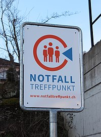
Tag:emergency=disaster_help_point
| Description |
|---|
| Marks places using as disaster help points |
| Group: emergencies |
| Used on these elements |
| Status: in use |
| Tools for this tag |
|
Marks places used as disaster help points. A disaster help point is a place where you can go to get help during an incident that has interrupted normal communication (a long power outage for example). You go there to get information, organize an ambulance or alert the fire brigade.
The points are usually just a sign at the designated place. They only get operational (with people being there to respond) in case of a disaster (see activation).
How to map
Place ![]() a node at the middle or draw
a node at the middle or draw ![]() an area along its outline. Add emergency=disaster_help_point.
an area along its outline. Add emergency=disaster_help_point.
Summary
Disaster help points serve as contact points in case of disasters.
The current discussion is held to a large part in German, as this proposal originates in Switzerland: https://wiki.openstreetmap.org/wiki/DE:Tag:emergency%3Ddisaster_help_point
Tagging
Recommended Attributes
- name=* – Name of the point. It should get the official country specific designation (for example «Notfalltreffpunkt X» or «Selbsthilfe-Basis Y»).
- operator=* – Name of the operator (typically the municipality or a governmental organisation)
- description=* - Description of the location of the point (for example School, Gym, Fire depot). This description should be simple and the Object easily regognizable on the ground.
- ref=* - (national) reference
- covering=* - Area this point covers
- activation=* - List of reasons this point is activated
- activation=flood
- activation=storm
- activation=blackout or activation=power_outage)
- activation=phone_breakdown - Phone and mobile network is out.
- activation:evacuation=yes/no - Coordination in case of evacuation
- In search of a proper tag: temporary=yes/no or permanent=yes/no, to declare if this place is used generally as point of contact, or only for a specific, single event. With this tag you could use this emergency=disaster_help_point also to support the population in case of a disaster in regions where such points are normally unknown.
With the following tags can be defined, which type of Help should be available:
- disaster_help_point:information=yes/no - You can get information, news.
- disaster_help_point:alert=yes/no - They take alerts for ambulance, fire fighters, police
- disaster_help_point:electricity=yes/no - Power for personal vital medical equipment
- disaster_help_point:drinking_water=yes/no - You can get drinking water
- disaster_help_point:shelter=yes/no - emergency shelter is offered
- disaster_help_point:healthcare=yes/no -There is medical personnel available (alternative: disaster_help_point:first_aid=yes/no)
Not necessary attributes, as they are automatically met in case of a disaster:
- disaster_help_point:meeting_point=yes/no - It should automatically become an assembly point for evacuation if necessary.
Further sensible attributes
- Adresse – Exact address of the place (postcode, city, housenumber, street)
- website=* – Webseite of the specific point
- phone=* – Phone number of the specific point or of the parent organization
Differentiation to other tags
emergency=assembly point
These are signposted assembly points to which people should go in case of an evacuation. They usually refer to localized objects such as individual buildings or small-scale areas and are used in the event of an incident such as a fire in that very building. An example is the assembly point of a company building, where the workforce of a company gathers when needed.
disaster help points, on the other hand, are at least communally organized and are only used in large, serious incidents. But then these places have more than just the function of a meeting place.
