Tag:historic=mass_path
| Description |
|---|
| Use on relations to combine highways into a mass path. |
| Group: historic |
| Used on these elements |
| Requires |
| See also |
| Status: in use |
| Tools for this tag |
|
Use the tag historic=mass_path on relations that define a mass path which people in the past (or maybe in the present) used to walk along to get to church or to school.
Mass paths were used as short cuts by people in the past to walk to church or as secret ways to other places of worship (like mass pits or mass rocks) where worship of a certain denomination was suppressed. Often, school children also used them, because the schools tended to be very close to the church, having been built on church land. Some have been turned into walking trails, but many are now inaccessible on private land, and the right of way has lapsed. They are sometimes still known about in the local communities. Stiles can be clues as to their existence.
How to map
Map the entire mass path as a walking route relation. Include disused paths and footways using disused:highway=* or was:highway=* with whatever value is suitable. Make sure to mark the access=* for all the parts of the mass path.
Add the tag historic=mass_path to the relation.
Additional tags
- loc_name=* or name=*: Do not just use "Mass Path" as a name. The mass path might not have an official name, and since there are often more than one leading to the one church or other place of worship, you can use a "[From] - [To] Mass Path" pattern. Sometimes, the pass path crosses a field whose name is still known, so you can use "[Fieldname] Mass Path".
- description=*
- wikimedia_commons=* - if there are photographs of the mass path on Wikicommons, preferably use the
Categoryor link to just one image, if there is only one. - wikidata=*: If there is wikidata of the mass path (you might have to create it yourself), you can link it here.
- source=*: This can include a link to the duchas.ie website with the text about this specific mass path.
- website=*: If the mass path has a website, because it is part of a walking trail now or on a local historical society website, you can link it there. This might include oral history of the mass path or photographs.
Gallery
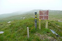
Charlie's Walk, a former mass path in Co. Kilkenny, Ireland (show on OSM)


