Tag:house=maisonette
| Description |
|---|
| A small residential dwelling, often split over two floors, inside a larger residential building, with its own private entry. |
| Group: buildings |
| Used on these elements |
| Requires |
| See also |
| Status: in use |
| Tools for this tag |
|
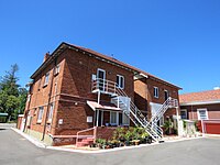
A residential dwelling, often split over two floors, located in a larger residential building. A maisonette has its own private external entrance, rather than a communal external entrance such as with building=apartments.
Alternate tagging
This tagging follows the building=house + house=* tagging scheme. The more popular tagging scheme is to tag houses via top-level tags (e.g., building=detached). In this instance, though, the house=maisonette tag is actually more popular than the equivalent building=maisonette tag.
As of June 2022, usage for both the building=maisonette and house=maisonette tags is exclusively in the United Kingdom.
See this OSM tag history as a curve chart which shows the development of the usage numbers of the different tags in comparison.
