Tag:industrial=gas_plant
Jump to navigation
Jump to search
| Description |
|---|
| A natural gas processing plant |
| Group: industrial |
| Used on these elements |
| Requires |
| Useful combination |
|
| Status: in use |
| Tools for this tag |
|
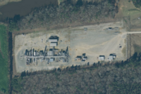
A natural gas processing plant is a facility where natural gas from wells is purified. Natural gas plants strip out liquids and impurities from the gas stream and send “dry” gas into the pipeline transmission system for consumption by end-users or injection into underground storage. They also produce high volumes of natural gas liquids (NGLs), including propane, which are used as refinery fuels and feed stocks, heating fuels, and other purposes.
They are commonly found within gas fields, or at the coasts at offshore fields.
How to map
Draw an area ![]() around the grounds of the gas processing plant or place a node
around the grounds of the gas processing plant or place a node ![]() at the centre of the grounds.
at the centre of the grounds.
Add
- landuse=industrial
- industrial=gas_plant
- name=*
- operator=*
- addr=*
- capacity=* gas processing capacity per day, add unit to the capacity value
Example
| Photo | Tagging | OSM Carto | Note |
|---|---|---|---|

|
industrial=gas_plant name=North Terrebonne Gas Plant operator=Enterprise Gas Processing, LLC capacity=1100 MMcf/d |

|
Example of a very large gas plant in Louisiana, US |

|
industrial=gas_plant name=Neal Gas Plant operator=Texas Petroleum Investment Company capacity=5 MMcf/d |

|
Example of a very small gas plant in Louisiana, US |
