Tag:man_made=bunker_silo
Jump to navigation
Jump to search
| Description |
|---|
| An open-sided structure without a roof that can be used with vehicles to fill and empty them |
| Group: man made |
| Used on these elements |
| Useful combination |
|
| See also |
| Status: approved |
| Tools for this tag |
|
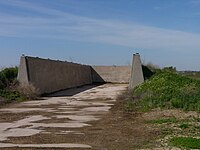
![]() Bunker silos are unroofed structures with at least one open side, which can be used with vehicles like a loader or tractor to fill and empty them. Bunker silos are common in agriculture for
Bunker silos are unroofed structures with at least one open side, which can be used with vehicles like a loader or tractor to fill and empty them. Bunker silos are common in agriculture for ![]() silage. They can be used for all kind of goods, which can be handled with a loader or tractor. Other usage are for sand, pebbles, gravel, other landscaping materials, manure, mulch, and the like.
silage. They can be used for all kind of goods, which can be handled with a loader or tractor. Other usage are for sand, pebbles, gravel, other landscaping materials, manure, mulch, and the like.
How to map
Draw the outline and add
Disambiguation
- (Silage-)Heaps, which have been simply heaped on a lawn, should not be mapped as man_made=bunker_silo, because these exist only for some months.
- Military bunkers or silos should be tagged with military=bunker instead.
- Three-walled racquetball courts may look similar in aerial imagery but should be tagged leisure=pitch sport=racquet instead.


