Tag:wetland=mud
Jump to navigation
Jump to search
| Description |
|---|
| Fresh water muddy areas |
| Group: natural |
| Used on these elements |
| Requires |
| See also |
| Status: in use |
| Tools for this tag |
|
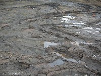
Indicates an Fresh water muddy areas covered with mud, that is wet, water saturated fine grained soil without significant plant growth. Mud natural=wetland+natural=mud can flow smoothly into the marsh natural=wetland+wetland=marsh
We can find in the river, lakes shoreline.
Areas of mud are a type of wetland, which we can divide into: natural=wetland + wetland=tidalflat Saltwater muddy areas. Tied with sea tides. natural=wetland + wetland=mud Freshwater muddy areas. Found in the riverside lakes, lakes.
How to map
Draw an area ![]() around the grounds of the mud and add natural=wetland + wetland=mud.
around the grounds of the mud and add natural=wetland + wetland=mud.
See also
- natural=wetland + wetland=tidalflat - for tidal mud flats
- surface=mud - used for example on highways
- natural=mud - Generally a muddy area. When you are not sure choose this tag.

