Talk:Tag:boundary=low emission zone
Discussion about the tagging of environmental zones
Requirements
- There shall be as little redundancy as possible.
- It shall be easy to see, if a street is in or outside the zone.
- It shall be possible to avoid the zone in routing software (Consider the punishment to be a 40€/150€250€/350€ toll, if you enter the zone without the mandatory badge... ;-) )
Ideas for solution
1) Map and tag as an area
Pro
- Streets that reach out of the zone but belong to it or that do not belong to the zone but reach into it can easily be outlined.
- Easy to adapt to possible changes of the zone. Just push the area-nodes to the new positions.
Contra
- Massive Redundancy.
- Not supported by routing software
Tagging
Idea 1a)
- Additional way
- Area = yes
- Name = Umweltzone Hannover
- Type = LEZ
2) Tag as a relation to existing ways
Pro
- No redundancy
Contra
- At the moment there are still technical difficulties to mark members of the relation.
- There will be the need of "ghost"-ways. In some areas the environmental border is not bound to an existing way.
Tagging
Idea 2a)
- Reuse the nodes of the streets of the outline of the zone
- relation
- type = LEZ
- name = Umweltzone Hannover
- access = badge 2
(Badge 2 = At least red badge)
Tagging of supraregional roads that cross the zone without belonging to it
- A tag is needed for ways to be excluded from the relation. There are already tags to exclude
areas from a relation. Idea
- Add the road to the relation and add a tag member=no or excluded or outer.
- This should be handled using members with special roles, e.g. role=exception, or possibly role=exception_in and role=exception_out. Robx 14:22, 21 July 2008 (UTC)
Open points
- Is there a way to force a relation to be a closed way? If there is a gap in the relation, the routing software might guide you through that gap(s) into or through the zone though you have requested to go around it.
- There's no way to force a way to be closed, either. You can just check whether it is. Robx 14:22, 21 July 2008 (UTC)
3) A new value in the border tag
Pro
- Border tag exists, handling is well known.
Contra
- The border tag is up to now totally irrelevant to routing software.
- Massive redundancy
- Tagging access = no does not help, because nobody will drive on a virtual zone.
Tagging
Idea 3a)
- New way
- area = yes
- type = border
- name = Umweltzone Hannover
4) A new value in the toll tag
Pro
- As the toll tag is know to routing software, there is no big new programming needed for routing.
Contra
- The relation between toll and environmental zone is somehow odd - it has nothing to do with toll at all as you don't have to pay for getting in there.
Pro
- I disagree: The toll for entering the zone (and getting caught) without the needed badge is 40 EUR! (Plus one point in Flensburg). The great advantage is, that the routing software usually asks if you want to go through toll zones. Thus there is no need to ask the user for the badge, you ask just an already installed question.--Lulu-Ann 22:16, 20 May 2008 (UTC)
Contra
- What you're talking about ist not a toll. You'll get a traffic ticket for this. Toll zones are not an access restriction, because one can pass there without doing something forbidden. But if your vehicle doesn't have the right badge, you are not allowed to pass there. If you're caught you'll get a traffic ticket, but this is not a toll fee! --Phonon 21:15, 22 May 2008 (UTC)
Pro
- I still disagree: At least there is a fee for buying the badge (5 to 10 EUR) if your car can get one. Sure it is not a toll in the definition of it, but however a toll zone is the closest solution for a routing software. An access zone is harder to handle: Routing software usually does not ask if you may enter such a zone: Either it tells you you can not go there (like to a pedestrian zone) or it assumes you are allowed to enter it (like industrial sites with security personnel). Please offer a better way to enable routing arond a LEZ!--Lulu-Ann 00:35, 23 May 2008 (UTC)
Pro
- Germany: There is a general exceptional permission for a day (Ausnahmegenehmigung) available for entering into the zone for 20 EUR. (May 2008)
It can be bought at the Local Public Office (Bürgeramt). I assume we should tag the Bürgerämter as toll booths.--Lulu-Ann 10:39, 24 May 2008 (UTC)
Contra
- You know what "toll booths" are, aren't you? These are little buildings standing directly on the road one have to pay for. Bürgerämter are spread all over the city. If you want to buy an "Ausnahmegenehmigung" one cannot do this on the specific road, but has to go to the Bürgeramt first. Please, do not mix up things that do not belong to each other. --Phonon 16:36, 24 May 2008 (UTC)
Pro
- Yep, I know what a toll booth is. Copied from wikipedia (en) : The building or facility where a toll is collected may be called a toll booth. As foreigners need to know where to buy the exceptionnel permission, and as the facilities are NOT right at the entrance to the toll zone, it is even more important to show them in the map. And no, we will not invent a new symbol for something, that is obvious.
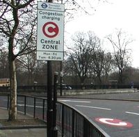
- UK: The Low emission zone in London is a charging zone anyway.
Tagging (Please correct the ideas 4a and 4b, I am not sure about the tagging of toll streets--Lulu-Ann 09:05, 24 May 2008 (UTC))
Idea 4a)
- Using the nodes of the outline streets
- toll = yes
Idea 4b)
- Using the nodes of the outline streets
- relation
- type = LEZ
- toll = yes
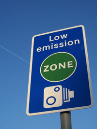
5) Tagging all positions of environmental zone signs
What about tagging the signs as nodes on the way and adding a new access-tag as an access and routing restriction?
<tag k="low_emission_zone" v="1|2|3|4" />
Where values are:
- (1) zone 1
- (2) zone 2
- (3) zone 3
- ...
Pro
- Easy to do
- Routing software can find a route if it knows the category of the vehicle. (Not true, see below)
Contra
- Lots of nodes to record
- Does not produce a visible area. Maybe these nodes could be connected to an area (see above).
- This is not an access tag! It is not known by any routing software by now.--Lulu-Ann 22:17, 20 May 2008 (UTC)
- Of course this is an access tag. The definition of LEZ is: "A Low Emission Zone (LEZ) is a geographically defined area which seeks to restrict or deter access by certain polluting vehicles with the aim of improving the air quality." It's restricting access on areas. So we should add a new access tag. It is not known by software right now, but we do not make the map for the softwares. If there is a new tagging-feature the software has to adapt this. --Phonon 16:43, 24 May 2008 (UTC)
- It's not an access tag right now, but would be easy to integrate in software like Navit. --Phonon 21:15, 22 May 2008 (UTC)
- What do you mean by "easy" to integrate? We are not talking about one software, but about a bunch of softwares. And nothing can be easier than using an already known tag. Let's ask the routing software programmers to join the discussion!--Lulu-Ann 00:40, 23 May 2008 (UTC)
- How does the routing software know if you are leaving or entering the zone at the sign?--Lulu-Ann 22:17, 20 May 2008 (UTC)
- On big roads with one way for each direction this is easy. Just place the sign on the way leading into the zone. On all other way the signs can have an extra tag "opposite_lane" (as used for cylcleways) depending on the direction of the way. If the way-direction goes inward, just place the sign, if it pionts outward add the extra tag. This way every software can handle this. --Phonon 16:36, 24 May 2008 (UTC)
Overall comments on the tagging methods
- Of the ideas presented here:
- 1 and 3 are the same, tagging method just being the argument. However the tagging proposed for these does not make sense to me, it seems to completely ignore the currently set conventions for tagging areas.
- 2 is likely to be difficult to do with current editors, adding a whole city to a single relation would be a very large prospect. However, it is the theoretically best way to go in terms of data structure. It would be fairly easy to parse by routing software. The tagging should be generalised to also allow support for London's Congestion zone (as well as its LEZ).
- 4 looks completely unusable by routers. Toll is inappropriate.
- 5 would be difficult for routers to use, if there's incomplete data you'd head into an area and get fined. No association between nodes and the area.
- I would probably support a mixture of 1/3 and 2 as the most sensible way forward. In any case, this proposal should be generalised to be more of a tagging proposal for 'limited access areas' so to include all large areas limited to some form of traffic.
--Thomas Wood 11:46, 4 June 2008 (UTC)
Hello Thomas Wood,
a) can you please explain why a toll tag should not be identifyable by a routing software?
b) can you explain, why you think a LEZ is not a toll zone?
c) can you explain, why the London LEZ is called "charging zone" then?
d) can you explain, why an area like in 1 or 3 should be easier to use by routing software than a toll zone?
A toll zone is a zone in which some vehicles have to pay to be allowed to enter. (Usually bicycles don't have to pay.)
I a German LEZ there are:
- vehicles, that don't need to pay (bicycles),
- vehicles that have to pay once (cars with low emissions: need to buy a badge, ~5 EUR),
- vehicles that have to pay several time (cars without a badge: special permission 20 EUR for a day or up to 120 EUR for a longer period),
- vehicles that may not pass (did not pay for a special permission - whether or not they would get a badge)
- and vehicles, that pay 40 EUR fee because the driver did not care for a permission and got caught. (Plus 1 "Punkt in Flensburg")
So as you can see, the low emission zone is nothing but a highly complex charging zone. Thanks --Lulu-Ann 14:12, 4 June 2008 (UTC)
Discussion about the rendering of the environmental zones
Rendering of the zone
Idea I
- Render as a red outline and transparent red filling for "at least red badge needed"
- The "transparent red filling" will require a new layer, otherwise the whole inner city will be rendered in a light red.
Idea II
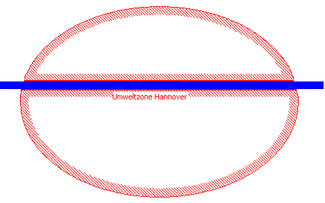
- Render as a red outline with a diagonal red line pattern to the inner side of the zone.
- The name of the zone shall be written on this diagonal red line pattern, i.e. "Umweltzone Hannover" for the Low emission zone in Hannover.
- If there is a way crossing the zone that does not belong, like a motorway where the LEZ restrictions do not apply, the way shall be rendered with the outline and the diagonal pattern as if the zone was around it.
Rendering of the locations where you can buy the badges (permanent permissions)
- Opening hours?
- ...
Rendering of the locations where you can buy the special permissions
- Opening hours?
- ...
How do the "others" handle this
- Map24 renders a green area. See: http://www.de.map24.com/umweltzonen and click on the name of the city you wish to see. If you plan a route, LEZ is not mentioned at the moment. So you don't know when and where you go inside this zone. May be just an overlay, which is not connect to routing.
- Google Maps: nothing found
- Falk.de: nothing found
- Yes, we are the first! --Lulu-Ann 14:06, 18 June 2008 (UTC)
Signs and badges
Germany
- See Straßenverkehrsornung (StVO) page 43 for the signs 270.1, 270.2 and the additional sign for 270.1.
(Please add the badges here)
UK
Old Discussion in German
- Frage: Wie sollen die Umweltzonen in der Karte repräsentiert werden? Wie wurde dies für die charging zone in London umgesetzt?
- In London scheint die "congestion charge zone" noch nicht erfasst zu sein. In Central London steht dies unter Todo. Auch wird es dort ab Februar eine wikipedia:London low emission zone geben. Das Thema sollte also sinnvollerweise OpenStreetMap-weit diskutiert werden. Robx 11:55, 17 January 2008 (UTC)
- Ich schlage vor, die Umweltzone einfach als einen geschlossenen Weg einzufügen. Dabei sollten wir nicht Straßen am Rand der Zone folgen, sondern parallel dazu gehen, da es Straßen am Rand gibt, die gerade so innen oder außen liegen. Eine Konvention wie "auf dem Rand" = "außerhalb" würde also nicht so gut funktionieren. Robx 11:29, 25 March 2008 (UTC)
- Wir müssten nicht nur die Zone erfassen, sondern auch die Daten, ab wann jeweils eine Verschärfung gilt, sowie die Klassifizierung in "Grün", "Gelb", "Rot", "Ohne" Plakette.--Lulu-Ann 15:58, 29 April 2008 (UTC)
boundary=low_emission_zone, don't use type
I propose to use a different tag: boundary=low_emission_zone. Reasoning:
- Don't use abbreviations in tags
- Don't use capitalization in formal tags
- Enable tagging of closed ways and multipolyon-relations with the same tag (type=* is reserved for relation types)
See here for the proposal: Proposed_features/boundary=low_emission_zone --Dieterdreist 14:12, 13 November 2012 (UTC)
Node tags on Ways
The boundary is fine for a general indication, but how do routers handle these zones? Is there a node tag on highways which is in use & I've not come across yet?--DaveF63 (talk) 13:32, 19 March 2021 (UTC)


