Template:DE:Map Features:information
Jump to navigation
Jump to search
Information
| Schlüssel | Wert | Element | Kommentar | Darstellung / Rendering | Foto |
|---|---|---|---|---|---|
| information | office | Ein Tourismusbüro, in dem Informationen über die Stadt oder Region zu bekommen sind. | |||
| information | visitor_centre | Ein Besucherzentrum | |||
| information | board | Eine allgemeine Informationstafel – wenn möglich mit board_type=* näher beschreiben. | |||
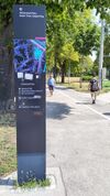
| information | stele | Eine Informationsstele | |||
| information | terminal | Ein Informationsterminal, an dem Informationen und Hinweise elektronisch abrufbar sind, häufig mit Internetzugang. | |||
| information | audioguide | Ein Punkt, an dem man Informationen (zum Beispiel über Kopfhörer) anhören kann. | |||
| information | map | Eine Tafel mit einer (Land-)Karte. | |||
| information | tactile_map | Ein reliefierte Blindenkarte mit ertastbaren Informationen. | |||
| information | tactile_model | Ein 3D-Modell zum Tasten für Blinde | |||
| information | guidepost | Ein Wegweiser an Wander- und Fahrradrouten, der Richtung (und ggf. Entfernung) zu verschiedenen Zielen anzeigt. | |||
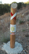
| information | post | A small pole, erected vertically, with information on the top or sides that may be inscribed, or on a small plaque. Somewhat similar to an information=stele, but smaller. | |||
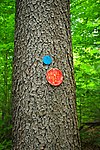
| information | Ein Wegerkennungsmarker/Zwischenwegweiser für eine Route, der z.B. an einen Baum angemalt oder anderweitig angebracht ist.
Achtung: Aktuell werden information=route_marker und information=trail_blaze parallel benutzt. Eine Differenzierung ist schwierig: trail_blaze soll wohl verwendet werden, wenn nur die Position einer Route markiert wird (ohne Richtungs- oder Zielangaben), während bei Markierungen mit Richtungsangabe (z.B. ein Pfeil) auf jeden Fall route_marker verwendet werden soll – viele Mapper benutzen es aber auch im Fall einer „reinen Positionsmarkierung“. |
||||
| information | user defined | All commonly used values according to Taginfo |
This table is a wiki template with a default description in English. Editable here.


