Den Haag
(Redirected from The Hague)
Jump to navigation
Jump to search
| V・T・E |
| latitude: 52.07, longitude: 4.30 |
| Browse map of Den Haag 52°04′12.00″ N, 4°18′00.00″ E |
| Edit map |
|
External links:
|
| Use this template for your locality |
Den Haag is a City in Zuid-Holland, the Netherlands at latitude 52°04′12.00″ North, longitude 4°18′00.00″ East.
Mapping Parties
Second mapping party: June 30-July 1 2007
Location
Restaurant Hagedis
Waldeck Pyrmontkade 116
2518 JR Den Haag
52.078517, 4.292457
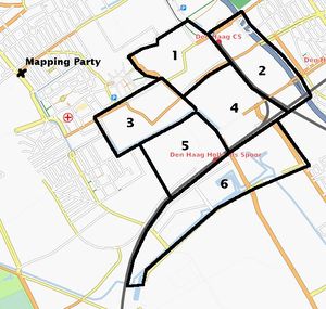
The location opens at 12:00. If you want to do some mapping in the morning, you can take one of the areas close to the railway stations (see the map on the right). Just write down below what area you will be doing, so that there'll be no double work.
Attendees
Saturday June 30th
- User:osm@floris.nu (I'll start working on area #3)
- GertGremmen
- Eugene van der Pijll (I'm reserving area #2, Bezuidenhout-West)
- Ante
- Ivar Clemens
- Michael (probably)
- Kleptog (I'll go for area #6)
- Martijn (I'm off NOW, hope to be there at 12!)
Sunday July 1st
First mapping party: April 14-15 2007
Location
Restaurant Hagedis
Waldeck Pyrmontkade 116
2518 JR Den Haag
52.078517, 4.292457
Contact information: User:ZoranKovacevic
Attendees
Saturday April 14
- User:ZoranKovacevic (i-blue/nokia770: unlimited,usb,gpx)
- User:Kleptog (nokia E60, bluetooth gps, unlimited logging)
- User:IvarClemens Garmin Vista Cx, eet niet mee
- User:Jip (RBT 2001, N73) probably only one day, because of http://www.deaf07.nl/
- User:JeroenDekkers (no GPS yet)
- User:Bas (has Zoran's Garmin)
- User:Eugene van der Pijll (probably; no GPS)
- User:Ante Garmin Geko 201
- User:Cagri (Magellan Meridian, enough storage. May be able to bring an extra BT gps)
Sunday April 15
- User:Kleptog (nokia E60, bluetooth gps, unlimited logging)
- User:osm@floris.nu
- User:IvarClemens Garmin Vista Cx, eet wel mee
- User:JeroenDekkers (no GPS yet)
- User:Bas (has Zoran's Garmin)
- User:Eugene van der Pijll (probably; no GPS)
- User:ZoranKovacevic (i-blue/nokia770: unlimited,usb,gpx)
Spare GPS units
If you have some spare gps's please put it in here:
- 1 Garmin Geko 201 User:osm@floris.nu (only on sunday)
- 1 Garmin Geko 201 User:ZoranKovacevic
There are 10 OSM Amaryllo Triptrackers available.

