Proposal:Timeline tags
| Timeline tags | |
|---|---|
| Proposal status: | Abandoned (inactive) |
| Proposed by: | Elvin |
| Tagging: | epoch=fromdate>todate |
| Applies to: | any feature |
| Definition: | tags allowing features to be located in time |
| Statistics: |
|
| Draft started: | |
| Proposed on: | 2008-07-17 |
See comparison of life cycle concepts for alternatives.
proposal
I am proposing a specific tag and a family of tags both intended to allow timeline mapping.
The specific tag is epoch and would allow any map feature to be tagged with from and/or to dates according to when the feature first appeared/disappeared in the landscape
The family of tags I call x-features and would apply to any ex-map feature which no longer exists. A Roman road whose route is not followed by a modern road would be tagged as xhighway=... or a deer park dating from Norman times might be tagged xlanduse=... These examples are appropriate to my own location in the UK but the principle clearly applies worldwide.
Almost all map feature tags might have equivalent x-feature tags which would be ignored by Mapnik and most other renderers but could be picked up by specialist software or a timeline-based map viewers. All x-features would need epoch tags, and other, standard features could be given epoch tags too. Like x-feature tags, the epoch tag would be ignored by most renderers but would allow software/viewers/renderers to recognise a current feature's place in the timeline.
why?
As well as maps and programming I am interested in local history. I have been reading about and visiting the sites of old roads in my locality and would like to be able to add historic roads to OSM. My idea is to be able to tag features by date and navigate the map not only in the N/S/E/W directions but also in the timeline, so I could step through time in a particular area and see the route of a prehistoric track re-used as a Roman road, continue in use through the Middle Ages, get diverted as land is enclosed or away from new houses, be upgraded in its new route as a turnpike road, become disused as railways, new roads along valleys and motorways come along, and finally fade away to become no more than a footpath or parish boundary. A similar approach could apply to almost any type of map feature. Such a time-based map approach could be invaluable to local history societies, academics and hobbyists who wold, I'm sure, get drawn into contributing data and expanding OSM back in time. A similar approach could work in the opposite direction too, allowing proposed new motorways and the like to be viewed by following the timeline into the future.
the tags
The x-feature tag is a simple, open-ended approach and could apply to almost any of the accepted feature tags. Present-day roads and paths are tagged as highway=... while old highways, no longer in existence, would be tagged xhighway=... The same could apply to canals which have disappeared or stretches of river which once took a different path: xwaterway=... abandoned airfields, no used for agriculture, housing or industrial estates would be xmilitary=airfield.
The epoch tag is more specific but still simple. The format would be epoch=YYYY>YYYY. The '>' must be present to separate the from date and the to date, either (but not both) of which could be omitted. Each date would be expressed as a year (using the standard western calendar) with 2000BC being -2000. A feature whose origin is lost in the mist of time but which is known to have disappeared around 1750 would be tagged epoch=>1750, while a road opened last year could be tagged epoch=2007>. A bridge built in 1933 and blown up in the second world war might be tagged epoch=1933>1944. Approximate dates could use 'round' numbers such as epoch=1300> for a building built somewhere around this period.
examples
A road near Mam Tor (the shivering mountain) in the Peak District was built in 1811 as an alternative to the steep Winnats pass road. Later classified A625 it suffered a series of land slips and was finally abandoned in 1979. The abandoned length of road could be tagged xhighway=primary ref=A625 epoch=1811>1979
Derby prison opened in 1827, became the town's greyhound stadium in 1932, closing in 1988, and was redeveloped in 1996 as Vernon Gate. Its outline on the map no doubt changed between these uses, but three closed ways could share some of the nodes and be tagged xamenity=prison epoch=1827>1932, xleisure=track epoch=1932>1988, and now landuse=residential possibly with epoch=1996>. Each of these three separate features (only the most current one appearing on most maps) could have its own extra tags such as name=.
The first section of the M1 (Watford to Rugby) opened in 1959 and could, as well as highway=motorway ref=M1, be tagged epoch=1959>
A church which was closed, converted to a museum to be later adapted as a pub (I'm thinking of High Pavement in Nottingham's Lace Market) might be tagged xamenity=place_of_worship and share its location with xtourism=museum as well as the current amenity=pub, each having appropriate epoch tags.
HistoryMap
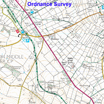
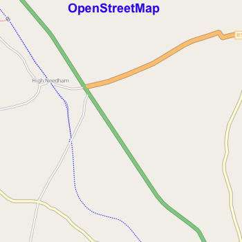
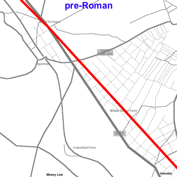
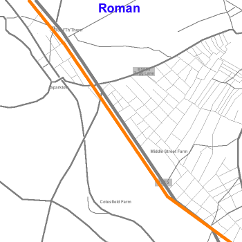
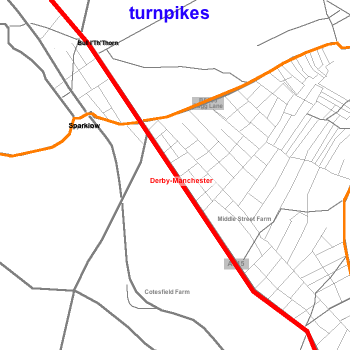
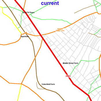
I would like to create a timeline-based viewer (I'm calling it HistoryMap) which would allow anyone interested in seeing how the landscape has developed over the years to step backwards and forwards in time with features extant at the time they are viewing appearing over a greyed-out background of the present-day OpenStreetMap to provide context. This woulld be no good without timeline-tagged data and this proposal, if adopted, would allow users to add historic (and planned) features and time-tag existing features. It is clearly impractical to create and store Mapnik type bitmap tiles for every year at every scale, so the viewer would draw vector (SVG?) images using data drawn straight from the OSM database. The script fetching the data would be looking particularly for x-feature and epoch tags and would cache the data for each tile/year to speed up the serving process and reduce the load on the OSM server. The following images show a small area in the Peak District, crossed, since prehistoric times by a significant highway. They show how the area looks now on the OS map and OSM, plus quick, crude mock-ups of how it might look in HistoryMap at different points in the timeline.
comments
Your comments are welcome on the discussion page.
voting
Not yet open
