Turku
| V・T・E |
| latitude: 60.45, longitude: 22.25 |
| Browse map of Turku 60°27′00.00″ N, 22°15′00.00″ E |
| Edit map |
|
External links:
|
| Use this template for your locality |
Turku is a city in Finland at latitude 60°27′00.00″ North, longitude 22°15′00.00″ East.
Instructions
- Turku/Åbo is a two language municipality so every street and most other related features have both Finnish and Swedish names. Both of these must be properly tagged for a feature to be considered complete. Ja sama suomeksi, och samma på svenska.
- Image highlighting named highways without a name:sv, from 30.5.2010
- Current data
- Highways are tagged according to their type/numbering with some exceptions
Data sources
City of Turku
The City of Turku has issued a waiver allowing use of its CC-BY 4.0 map data for OpenStreetMap[1]
Bing
Bing covers Turku with high resultion aerial images (87288825![]() 87288825) from summer 2008 with a zoom level dept until 19. The area covers also Raisio, Kaarina and Naantali. For other Bing coverage in Finland, see Bing/Coverage#Finland.
87288825) from summer 2008 with a zoom level dept until 19. The area covers also Raisio, Kaarina and Naantali. For other Bing coverage in Finland, see Bing/Coverage#Finland.
Data coverage
Major Roads around Turku
- All major roads are complete: Valtatie 1/E18, Valtatie 8/E8, Valtatie 9/E63, Valtatie 10, 40, 110, 222, 1821.
Municipality and suburb borders
There are currently no exact borders. Request to the city has been made to get city borders, unfortunately the request was denied.
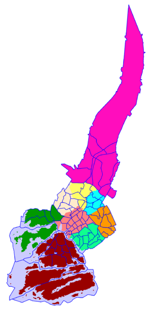
Approximated borders with wards has been re-engineered from Wikipedia "Wards of Turku" with a low resolution border map: http://warper.geothings.net/maps/preview/2177 Accuracy is not good enough to be mapped, but should give you some picture of suburb and ward borders.
Wards of Turku
The city of Turku, is divided into nine wards (suuralueet in Finnish, storområden in Swedish), which are further divided into 78 districts (see Districts of Turku). The ward division does not always follow district boundaries.
- City Centre (Keskusta/Centrum)
- Hirvensalo-Kakskerta
- Uittamo-Skanssi (Uittamo - Skansen)
- Itäharju-Varissuo (Österås - Kråkkärret)
- Koroinen (Korois)
- Tampereentie (Tammerforsvägen)
- Kuninkoja
- Naantalintie (Nådendalsvägen)
- Maaria-Paattinen (S:t Marie - Patis)
Amenities
- Almost all pubs/bars/dance places in the city center added, some small ones missing.
- Most Pharmacies in city center added
- Major supermarkets added
Routes
- Bus routes
- Cycle routes. There are plenty of official cycle route in Turku and to neighboring municipalities. Work is in progress to get these on the map.
- The City of Turku has also theme based routes.
Road features
Roads features should also be tagged properly, for examples lanes, maxspeed and turn restrictions. Some of these have been added, but many are still missing.
Citydistricts/Suburbs
Most of these have been added as suburbs (as nodes only, borders are missing), some might still be missing.
A - M
| Citydistrict/Kaupunginosa | Tiet/Streets | Pyörätiet/Cycleways | Comments |
|---|---|---|---|
| Artukainen/Artukais | ? | ? | |
| Halinen/Hallis | 100% | ~50% | Pyöräteistä puuttuu. |
| Harittu | 5% | ? | |
| Hepokulta | ? | ? | |
| Hirvensalo | 10% | ||
| Härkämäki | ? | ? | |
| Ilpoinen/Ilpois | 5% | ? | |
| Ispoinen/Ispois | 100% | ? | |
| Iso-Heikkilä | 100% | 100% | Complete |
| Itäharju/Österås | ~95% | ~10% | Puuttuu: kevyt liikenne, Mikkolanmäen polut |
| Jyrkkälä | ? | ? | |
| Jäkärlä | ? | ? | |
| Kakskerta | 5% | Big road around done. All small roads are missing. | |
| Kastu | ? | ? | |
| Katariina | 5% | ? | |
| Keskusta | ~99% | 100% | Pretty much complete, some service roads missing |
| Kohmo | 99% | 5% | A few roads to new housing is missing, otherwise pretty complete. |
| Koivula | 90% | 10% | A few names missing, otherwise almost complete |
| Koroinen | ? | ? | |
| Korppolaismäki | |||
| Kupittaa | 99% | 100% | Pretty much complete |
| Kurala | ? | ? | |
| Kurjenmäki | 99% | ? | Pretty much complete |
| Kähäri | ? | ? | |
| Kärsämäki | ? | ? | |
| Lauste | ~95% | ~95% | Pretty much complete, service roads missing |
| Luolavuori | 90% | 99% | Pretty much complete, some service roads missing |
| Maaria | ? | ? | |
| Majakkaranta | 99% | ? | Pretty much complete, some service roads missing |
| Martti | ? | ? | |
| Metsämäki | ? | ? | |
| Moisio | ? | ? | |
| Mälikkälä | ? | ? | |
| Mäntymäki | ? | ? |
N - Y
| Citydistrict/Kaupunginosa | Tiet/Streets | Pyörätiet/Cycleways | Comments |
|---|---|---|---|
| Nummi/Nummis | 98% | 100% | Pretty much complete, some service roads missing |
| Oriketo | 100% | 50% | |
| Paattinen/Patis | ? | ? | |
| Pahaniemi | 100% | 100% | Complete |
| Pansio | 95% | Pretty much complete, some service roads missing | |
| Peltola | ~80% | Almost complete. Peltolan siirtolapuutarha. | |
| Perno | ? | ? | |
| Pihlajaniemi/Rönnudden | ? | ? | |
| Pitkämäki/Långbacka | ? | ? | |
| Pohjola/Norrstan | ? | ? | |
| Port Arthur | 99% | 100% | Missing name:sv for a couple roads, otherwise roads are complete |
| Puistomäki | ? | ? | |
| Pääskyvuori/Svalberga | 95% | ? | Missing a couple names. |
| Raunistula | 50% | Almost all roads, needs names | |
| Ruissalo | 20% | Major road, some small roads | |
| Runosmäki/Runosbacken | 80% | 80% | Almost complete |
| Ruohonpää | ? | ? | |
| Räntämäki | 99% | 60% | |
| Satava | 95% | ? | Pretty much complete, some service roads missing |
| Teräsrautela | ? | ? | |
| Tortinmäki | ? | ||
| Uittamo | 85% | 0% | Most major roads. Cycleways and names missing. |
| Urusvuori | ? | ? | |
| Vaala/Svalas | 90% | 90% | Pretty much complete. Missing almost all Swedish names. |
| Varissuo/Kråkkärret | 90% | 90% | Pretty much complete. Missing almost all Swedish names. |
| Vasaramäki | ? | ? | |
| Vähäheikkilä | 90% | ? | |
| Vätti | ? | ? | |
| Ylioppilaskylä/Studentbyn | 95% | 10% | Most streets are in place, names are missing |
| Yli-Maaria | ? | ? |
Quality Assurance
The following tools are useful for verifying quality:
- Notes, keepright, OSM Inspector and Mapdust are linked in the green place box.
- Transparent map comparison (Mapnik vs. Google Maps)
- Map Compare (Mapnik vs. Google Maps)
Comparison with other maps may be useful:
- Kansalaisen Karttapaikka, topografic map
- Kansalaisen Karttapaikka, orthophoto
- Turun Seudun Karttapalvelu
- Eniro tie kartasto
- Metsähallituksen retkikartta
- Yahoo maps
- Bing maps has high-res aerial, street map and bird's eye
- GeoHack
Because of the copyright restrictions you are not allowed to copy the maps. It's good to compare them with your own GPS surveying, as assurance that your mapping is correct. Also doing comparison where mapping is needed is useful.
Read more about Quality Assurance ...


