User:Achadwick/Mapping style
Documenting my personal approach to mapping here.
Areas vs. non-areas
![]() s should not share way segments with ways that are
s should not share way segments with ways that are ![]() s. Abutting them in this way distorts the shape of the area for very little actual benefit, and is bad mapping practice. I'll tend to try to keep the road and path network separate in places I map, joining only at gateways and other features at crossing points.
s. Abutting them in this way distorts the shape of the area for very little actual benefit, and is bad mapping practice. I'll tend to try to keep the road and path network separate in places I map, joining only at gateways and other features at crossing points.
I'll join areas to other areas at the edges though, when appropriate.
Fancy access restrictions
We have quite a few in Oxford, and since it's OK to invent syntax that doesn't actively clash with access=* I gave them a go. Some have been updated since the approval of Conditional_restrictions.
| Photo | How I've tagged it (in the past) | Remarks | Updates after approval of conditional restrictions |
|---|---|---|---|
| highway=tertiary motor_vehicle=no |
Nice and simple, this one. The current Access schema is fine for this restriction.
Well, mostly. The above also kills the maximum-speed restriction during the off hours if you read the schema fully. Might revisit that... |
||
| highway=tertiary bus=yes The no-through-road restriction refers to the bus gate above. Done separately. |
This was mostly fine with the old schema, but I had to invent a maxoccupants tag.
After Conditional restrictions, the tagging is a *lot* simpler. |
highway=tertiary bus=yes | |
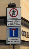
| highway=unclassified motor_vehicle=no |
Invented (and ugly) syntax. But at least it doesn't upset the 20mph restriction.
Really want a nicer way of expressing the length condition. |
||
| highway=pedestrian motor_vehicle=no barrier=bollard |
Cornmarket itself is impossible with the current schema: hour_on and hour_of would remove the motor vehicle restriction as well. The only thing to do is attempt something backwards-compatible. I've tentatively introduced "yes-times" and "no-times" to cover the two different cases and permission senses.
The bollard however, can be represented with the current schema. The only odd thing I've done is refine the bollard type a bit. |


