User:Gyotoku810/Sandbox
利用者サンドボックスです。
Japan tagging
このページは日本のOSMコミュニティにおける(主に道路の)タグ付けの指針として過去に多くの議論を重ねてできあがったもので、英語版の翻訳ではありません。 従って大きな改版をする際はOpenStreetMap Japan メーリングリスト でお知らせ、意見交換されることを望みます。
This page lists recommendations for tagging things in Japan. Regarding the tags not listed below, follow the description of Map Features page. See also Japan. For an example of Tagging is, JA:Naming sample or JA:Howto Map A will be the reference.
(ja)このページには日本のマッピングで推奨されるタグ付けルールが記載されています。このページに載っていないタグについてはJa:Map Featuresページの記述に従ってください。また、Japanも参照してください。 タグ付けの実例については、日本におけるチェーン店のname値の実例や五十音順POIタグ一覧が参考になります。
Highway
Road types
In Japan, there are pre-defined tags for each element -- these are listed in the "Implies" column. If a road does not match that column, tweak the relevant tags.
日本では、これらのhighway タグを付けることは、"Implies"の列にリストされている各要素的タグをつけたのと同じ意味を持ちます。もし、それらの"Implies"に道路の実態があってないのなら、要素的タグを加えて、訂正してください。
| Key | Value | Element | Comment | Example | Typical image | Useful combination よく併用されるタグ | Implies 含まれる意味 |
|---|---|---|---|---|---|---|---|
| highway | motorway | Expressways or motor roads. If you see a sign drawn a white car in blue background: 自動車専用道路。青地に白い車の標識のある道。 高速道路、有料道路、国道のバイパスなどにこの標識があったらこれに分類します。 |

Tomei Expressway (東名高速道路), Shuto Expressway (首都高速道路), Hachioji Bypass (八王子バイパス), Hakone Turnpike (箱根ターンパイク). |
| |||
| highway | motorway_link | The link roads (sliproads / ramps) leading to and from a motorway. Normally with the same motorway restrictions.
自動車専用道路への出入りに使用する連絡路や加速車線。通常は自動車専用道路と同じ利用制限が適用されている。 |

|
| |||
| highway | motorway_junction | Indicates a junction or exit ref should be set to the exit number or junction identifier.
自動車専用道路のインターチェンジ(出入口)の番号を表示する際に使用する。 |

|
| |||
| highway | trunk | National highways excluding expressways and motorways. Usually, National highways have blue triangle shield signs: Note that a little part of Japanese National highways have regions which cannot be accessed by motor vehicles, for example, steps, a pedestrian, a hiking way, or a ferry route. Those region should be tagged by other highway tags and add it to Relation:route with route=road and ref=number. 国道。国道の道路標識がある道。但し、自動車専用道路の区間は除く。 基本的には逆三角形のいわゆるおにぎり標識がある道路はこれに分類します。 例外的にtrunk(幹線)とはとても呼べない国道(いわゆる「酷道」)の存在が知られていますが、 これらは別途タグやリレーションを補って実態に合った表現をすることが推奨されています。 |

|
||||
| highway | trunk_link | The link roads (sliproads / ramps) leading to and from a trunk road.
国道間又は国道への連絡路や加速車線。 |
| ||||
| highway | primary | Major Prefectural road, numbered with one or two digits and maintained by the prefecture. If you see a hexagonal shield sign, A region of expressway, motorway or road that cannot be accessed by motor vehicles should be tagged using other highway tags and added to Relation:route with route=road and ref=number. 主要地方道。 六角形のいわゆるヘキサ標識があり、標識の数字が2桁以下の(東京都などの一部都道県を除く)主要な都道府県道または市道。東京都では標識の数字が3桁でも300番台か400番代の場合は主要都道です。 自動車が通行できないような主要地方道(いわゆる「険道」)の存在が知られていますが、 これらは別途タグやリレーションを補って実態に合った表現をすることが推奨されています。 |

Hokkaido Route 1 (北海道道1号小樽定山渓線), Tokyo Route 318 (東京都道318号環状七号線). |
||||
| highway | primary_link | The link roads (sliproads / ramps) leading to and from a primary road.
主要地方道への連絡路や加速車線。 |
| ||||
| highway | secondary | Minor Prefectural road, numbered with three digits and maintained by the prefecture. If you see a hexagonal shield sign A region of the road that cannot be accessed by motor vehicles should be tagged by other highway tags and added to Relation:route with route=road and ref=number. 一般地方道。 六角形のいわゆるヘキサ標識があり、標識の数字が3桁以上(例外あり)の一般(主要地方道では無い)都道府県道。ただし、東京の都道で数字が300番台か400番代の場合は一般都道ではありません。 自動車が通行できないような一般地方道(いわゆる「険道」)の存在が知られていますが、 これらは別途タグやリレーションを補って実態に合った表現をすることが推奨されています。 |

|
||||
| highway | secondary_link | The link roads (sliproads / ramps) leading to and from a secondary road.
一般地方道への連絡路。 |
| ||||
| highway | tertiary | For 2 lane roads (1 lane each way and drawn a center line, or 2 lanes one way) within a shi (city), a machi (town) or a mura (village). This should not be a major (motorway, motorway_link, trunk, trunk_link, primary, primary_link, secondary, or secondary_link) road or a residential road. | 
|
||||
| highway | tertiary_link | The link roads (sliproads / ramps) leading to and from a tertiary road.
一般道路への連絡路。 |
| ||||
| highway | unclassified | Narrow and paved roads, less than 2 lanes. This includes low grade roads, provided they are important to interconnect the grid network. This should not be a residential road.
一般道(2車線未満)。 1.5車線以下でセンターラインも無いが、交通ネットワークを形成する舗装路。 舗装林道や圧石路も含む。 |

|
| |||
| highway | residential | For roads within a residential area, public facility, compound, or private area. Typically, this is not a road designed for driving through an area, but rather for driving to it.
居住区域内道路。 住宅街にある道路で、通り抜けを目的としていない道路。 |

|
| |||
| highway | service | Service roads. parking aisles, roads in a park, roads in industrial factory, etc.
敷地内道路。 駐車場、広い工場、公共施設、テーマパーク、ショッピングセンターなどの敷地内で通り抜けを目的としていない道路。 |
| ||||
| highway | pedestrian | For roads used mainly or exclusively for pedestrians. For example, shopping streets, or pedestrian roads in universities or big parks. You can see 歩行者専用道路。 歩行者用広場、商店街、広い歩行者用道路など終日歩行者天国のような場所。 |

|
| |||
| highway | cycleway | Separate ways for the exclusive use of cyclists. You can see a sign |

|
自転車以外の'軽車両'や'小型特殊自動車'に関しては、標識等で通行を許可/禁止する表示がある場合に限り
|
| ||
| highway | footway | Footways, mainly in cities and paved. You can see 遊歩道。 主に街中にあるもの。 |

|
|
| ||
| highway | path | A path, mainly out of cities and unpaved, which cannot be accessed by motor vehicles.
小道。 主に山や野原にあるもの。歩行者専用とは謳っていないが、事実上車は通行不能な道。 |

|
| |||
| highway | track | Agricultural or forest roads. The definitions for grades are the same as the other countries.
農道または林道。ただし「農道」または「林道」と名前がついている場合でも、一般車両の通行が多い舗装道路は別のタグをつける。 |

|
|
- 2021-10-31 '高速道路ナンバリング'の対象を追加する提案「Proposed JapanTagging/RoadTypes/motorroad]」(Rejected)
- 2019-05-28 'Implies'と'Useful combination'が改定されました「Proposed_Japan_tagging/Road_types」(承認済み)
- 2019-04-15 Proposed_Japan_tagging/Road_types_2/cycleway (承認済み)
Road names
| Usage | Example | Notes |
|---|---|---|
| name=Japanese |
|
|
| name:en=English or romanization of Japanese |
|
Although it is a common practice by some taggers to add english in parenthesis after the Japanese in the name=* field, the only place English should be added is in this field. Other taggers will delete English in parenthesis added into name=* . Bilingual support in OSM renderings is being discussed, and proper use of the name:*= tag will ensure it's correct operation in the future. |
| name:ja=Japanese |
|
- |
| name:ja-Latn=romanization of Japanese |
|
-JA:Key:name:ja-Latn |
| name:ja-Hira=Pronounciation of Japanese (in Kana) | -JA:Key:name:ja-Hira |
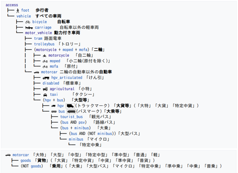
Access:transportation mode / 交通手段による制限 - 陸上交通 車両種別アクセス
- Japan tagging/Acces:transportation_mode / 交通手段による制限 - 陸上交通 車両種別アクセス
- JA:Key:access#交通手段による制限-陸上交通 に関する日本でのタグ付け指針を示しています。
Places
Usage of place=* for Japan tagging.
(ja)place=*の日本での使い方です。
- 2022-06-16 改訂承認: Proposed_Japan_tagging/Places
| Key キー |
Value 値 |
Element 要素 |
Description 説明 |
Relation to admin_level admin_levelとの関係 |
Notes 備考 |
|---|---|---|---|---|---|
| place | country | A nation. 国 |
admin_level=2 | Japan. 日本。424313451 | |
| place | state | A state. 州 |
admin_level=3 |
Not currently used in Japan. This tag is reserved for a state when state system is enforced. | |
| place | region | A region. 地方 |
The eight regions (Hokkaido, Tohoku, Kanto, Chubu, Kinki, Chugoku, Shikoku, Kyushu). They are not official administrative units. | ||
| place | province | A prefecture. 都道府県 |
admin_level=4 | The 47 prefectures. 47都道府県。 | |
| place | subprovince | A subprefecture of Hokkaido. 北海道の総合振興局・振興局 |
admin_level=5 | ||
| place | county | A county (郡, gun) in a prefecture. 郡 |
admin_level=6 | ||
| place | city | A city (市, shi) or a special ward (the "twenty-three wards" of Tokyo). 市 / 特別区 (東京23区) |
admin_level=7 | ||
| place | town | A town (町, chō or machi). 町 |
admin_level=7 |
"町" is used for both municipalities and place names under municipalities. Do not confuse them. | |
| place | village | A village (村, mura or son). 村 |
admin_level=7 | ||
| place | suburb | A ward (区, ku) in "a city designated by government ordinance of Japan" 政令指定都市における区 |
admin_level=8 | ||
| place | quarter | A larger unit than a place=neighbourhood (if there are two levels of administrative units under a municipality) place=neighbourhoodより広い行政単位(市区町村以下に二段階の地名が存在する場合) |
admin_level=9 | 大字 (大字の下に字がある地域の場合) に使用します。 | |
| place | neighbourhood | An administrative unit under a municipality 市区町村以下の行政単位 (町字) |
admin_level=10 | 町・丁目、字、小字、大字 (大字の下に字がない地域の場合) に使用します。形式については#町字名についてを参照してください。 | |
| place | hamlet | A hamlet or a locally-used place name as an informal address 集落 / 通称地名 |
Does not include mere regional nicknames. 単なる地域の通称は含まれません。 | ||
| place | island | An island 島 |
町字名について
以下のタグにおける地名の入力形式についてです。
- place=quarter
- place=neighbourhood
- boundary=administrative+admin_level=9
- boundary=administrative+admin_level=10
丁目を含む地名
「八幡一丁目」のように丁目を含む地名は、ほとんどの場合それ自体で一つの町名です。したがって「place=neighbourhood+name=八幡一丁目」とタグ付けします。大字が八幡、小字が一丁目であると解釈するのは誤りです。
横浜市や松戸市の一部地域の「字丁目」のように丁目が小字であるケースが稀に存在しますが、一般の認識においては全く区別することができません。この場合も原則として町名と丁目を繋げてplace=neighbourhoodに入力してください。
丁目の漢数字表記
町名に含まれる「○丁目」は原則漢数字で表記します。これは多くの場合地方自治法第260条第2項に基づく町や字の名称の告示が漢数字でなされているためです。北海道における「○条○丁目」のように専ら算用数字が用いられる地域などでは、実情に応じて算用数字で表記することも可能ですが、地域内で表記を統一してください。
大字・小字のタグ付け
「大字○○」、「字○○」という地名の「大字」や「字」はしばしば省略されます。この場合name=*にこれらを省略した地名を入れ、省略しない正式名称はofficial_name=*に入れることが可能です。
町や村を冠した地名
市町村合併を経た地域などでは合併前の町村名を冠した地名が存在することがあります。例えば「郡山市安積町長久保一丁目」や「郡山市日和田町広野入」などです。「安積町長久保一丁目」はこのとおりに町名が告示されているため「place=neighbourhood+name=安積町長久保一丁目」とします。一方で「日和田町広野入」は正式には「日和田町字広野入」とも表記され、「字広野入」が小字です。したがって「place=quarter+name=日和田町」、「place=neighbourhood+name=広野入+official_name=字広野入」とします。地名が一つの町名なのか小字なのかは市町村が公表する情報を参照してください。
区を冠する地名も存在します。例えば「姫路市広畑区富士町」では、「広畑区」は政令指定都市の区ではなく町名の一部です。したがって、「place=neighbourhood+name=広畑区富士町」とします。
登記のみに存在する小字
登記上の住所にのみ小字が存在し住民票などの通常の住所表記には小字が一切用いられない地域があります。その場合の小字はplace=neighbourhoodとしてはマッピングしません。通常使用される町名までをplace=neighbourhoodに入れます。ただし、龍ケ崎市の一部地域のように、公式な住所表記では市直下に地番が来る場合で、便宜的に小字が使用されている地域では小字をplace=neighbourhoodとしてマッピングします。
詳細な例
スプレッドシートにさまざまな地名のタグ付け方法をまとめました。
Notes about place names
|
|
Example of place names
| Type 種類 |
Combination 一緒に使うタグ |
Example of tag value タグの値の例 |
Notes 備考 | |||
|---|---|---|---|---|---|---|
| Key:place | name | name:en | name:ja | name:ja-Latn | ||
| Continent 大陸 |
place=continent | Asia | Asia | アジア | Ajia | - |
| Country 国 |
place=country | 日本 | Japan | 日本 | Nippon | - |
| Regions 地方 |
place=region | 近畿 | Kinki Region | 近畿 | Kinki | - |
| Prefectures 都府県 |
place=province | 大阪府 | Osaka Prefecture | 大阪府 | Ōsaka-fu | - |
| County 郡 |
place=county | 比企郡 | Hiki County | 比企郡 | Hiki-gun | 郡 (County) は以前はDistrictと訳すこともあったが、国土地理院の規程[1]もCountyとなっており、Countyに変更する。 |
| Cities 市 |
place=city | 佐賀市 | Saga | 佐賀市 | Saga-shi | - |
| Towns 町 |
place=town | 土佐町 | Tosa | 土佐町 | Tosa-chō | - |
| Villages 村 |
place=village | 佐井村 | Sai | 佐井村 | Sai-mura | - |
| Major municipal districts, well-known areas. 区 |
place=suburb | 鶴見区 | Tsurumi | 鶴見区 | Tsurumi-ku | - |
| Major municipal districts, well-known areas 大字 / (市町村配下の)町 |
place=quarter | 久米 | Kume | 久米 | Kume | - |
| Minor municipal districts 小字 / 字 / 丁 / 町丁(丁目) |
place=neighbourhood | 2丁目 | 2-chome | 2丁目 | 2-chōme | - |
| Unpopulated, named places. 住所の表示に使用されない地名、居住地以外の地名。 |
place=locality | 野島崎 | Nojimazaki | 野島崎 | Nojimazaki | - |
| Island 島 |
place=island | 利尻島 | Rishiri Island | 利尻島 | Rishiritō | - |
| Key:aeroway | name | name:en | name:ja | name:ja-Latn | ||
| Airport 空港 |
aeroway=aerodrome | 佐渡空港 | Sado Airport | 佐渡空港 | Sado Kūkō | - |
| JA:Key:railway | name | name:en | name:ja | name:ja-Latn | ||
| Station 駅 |
railway=station | 萩 | Hagi | 萩 | Hagi | - |
Names
More examples: JA:Naming_sample
References
- ↑ “地名等の英語表記規程” (PDF). 国土地理院. 2016-03.


