User:Maning/Marikina
Jump to navigation
Jump to search
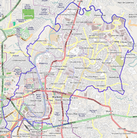
This is my status logs for mapping Marikina City, I made this page as a diary/checklist/planner for completing my OSM patch. Anyone is welcome to join in mapping.
| V・T・E |
| latitude: 14.647, longitude: 121.1048 |
| Browse map of Marikina 14°38′49.20″ N, 121°06′17.28″ E |
| Edit map |

|
|
External links:
|
| Use this template for your locality |
Marikina is a city in the Philippines at latitude 14°38′49.20″ North, longitude 121°06′17.28″ East.
Status by barangay
| Barangay | Roads | POIs | Admin Boundaries | Landuse | House numbers | Buildings | Remarks |
|---|---|---|---|---|---|---|---|
| Barangka | complete | complete | ~40% | ~50% | |||
| Calumpang | complete | complete | ~80%, need to survey roads Evangelista, Everite, Kalbaryo, Kalantiao, Justa, Fernando | ~10% | |||
| Industrial Valley | complete | need to add admin_centre | ~25% | ||||
| Jesus dela Pena | complete | complete | ~50% | ||||
| San Roque | complete | need to add admin_centre | ~20% | ~50% | |||
| Santa Elena | complete | need to add admin_centre | ~50% | ||||
| Santo Niño | complete | complete | ~20% | ||||
| Tanong | complete | need to add admin_centre | ~70% | ||||
| Concepcion Dos | complete | need to add admin_centre | ~80% | ||||
| Concepcion Uno | complete | need to add admin_centre | ~40% | ||||
| Fortune | complete | complete | ~20% | ||||
| Malanday | complete | need to add admin_centre | ~10% | ~50% | |||
| Marikina Heights | complete | complete | ~40% | ||||
| Nangka | need to add admin_centre | ~20% | |||||
| Parang | complete | need to add admin_centre | ~20% | ||||
| Tumana | complete | complete | ~20% |
Checklist of things to map
Clean-up tasks
- Follow the "One feature, one OSM element" guideline.
- Tasking Manager - http://tasks.hotosm.org/job/573
Commercial strips
Major roads where there are concentration of shops, offices and amenities.
| Road | Status |
|---|---|
| A. Bonifacio | Completed the stretch from Riverbanks to right after the bridge of Marikina |
| J. P. Rizal | Completed stretch from Marikina Bridge to Calumpang |
| Shoe Avenue | |
| Gil Fernando | |
| Juan Sumulong | |
| Gen. B. G. Molina | |
| Gen. Ordonez | |
| Katipunan | |
| E. de la Paz |
Schools
Task
- School grounds perimeter
- School buildings
Public Elementary Schools
- St. Mary Elementary School
Public Secondary Schools
- Santan High School
Notable Private Elementary and Secondary Schools
- Covenant Children Academy
- Gentle Angels School
- Jehoshua High School (JHS)
- OB Montessori Marikina Branch
- MDC Christian School
- Nativity of Our Lady Parochial School
- San Lorenzo Ruiz de Manila School
- Gentle Angels School
- Marikina Christian Academy
Tertiary and Vocational Schools
- AMA Computer University - East Rizal
- AMA Computer Learning Center Cainta
- AMA Computer Learning Center Marikina
- Asian College of Science and Technology - Sumulong Highway
- National Cottage Industries Technology Center - need resurvey
- STI Computer College Marikina
Health Facilities (hospitals and health centers)
Public Hospitals
- Marikina Diagnostic and Specialty Center
Private Hospitals
- The Medical City Marikina
- Sta. Monica Hospital
Barangay Health Centers
Other notable landmarks
- Marikina Bikelanes - need resurvey
Gated subdivisions
Check on boundaries of gated subdivisions
Public transport
- jeepney and tricycle stations
- Public transport routes
- Calumpang - Cubao
- Pasig - Marikina
Other things
- bike and motorcycle parking
- small community parks, playgrounds and basketball courts
- stream and storm drains