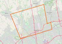
Vaughan
Jump to navigation
Jump to search
| V・T・E |
| latitude: 43.8563, longitude: -79.5085 |
| Browse map of Vaughan 43°51′22.68″ N, 79°30′30.60″ W |
| Edit map |

|
|
External links:
|
| Use this template for your locality |
Vaughan is a city in Ontario, Canada at latitude 43°51′22.68″ North, longitude 79°30′30.60″ West.
Ongoing Projects
Mapping Sidewalks, Stop Signs, Crosswalks, etc.
Completed:
- Most major roads in the south except for Bathurst (Centre - Hwy 7, awaiting satellite), Hwy 7 (Wigwoss-VMC, waiting satellite).
Businesses
Completed:
- Plazas at Dufferin/Major Mack
Major Changes Coming
- Rutherford GO - upgrades to be complete in 2020. <- not completed yet in 2021
- Highway 427 - under construction.
- Major Mackenzie Drive widening and
realignment- under construction. - Mackenzie Health Hospital - now open, awaiting new satellite imagery
- Vaughan Metropolitan Centre - new developments
Other changes required
- Need to complete mapping of buildings, which are completely lacking in many areas. Ontario Building Import had imported some buildings.
- Need to complete mapping of sidewalks. Some areas are done.
- Very minor details (such as streetlights, signs, etc.) are extremely lacking compared to neighbouring Toronto.
- Local businesses need to be added. Many areas are lacking.
- GO Transit routes need to be up to date and standard. See GO Transit for route relations.
Ongoing Updates
- VIVA/YRT completely updated as of Jan 21, 2021. See York Region Transit for route relations.
Finished
Thornhill Woods area has major alignment issues.VivaNext (Woodbridge). This has opened. Awaiting updated satellite images.VivaNext (Bathurst Street, Centre Street). Crossing and sidewalks need to be done pending satellite images.Major Mackenzie Drive realignmentCanada's Wonderland needs some updating