Water management

|
| Description |
| The management of water supplies, including reservoirs, locks and dams, but also pipelines, water treatment plants and fountains. |
| Tags |
|
landuse=reservoir |
Water management covers human management of water including reservoirs, canals locks and weirs, as well as waste water treatment plants, water pipelines, public drinking taps and fountains.
Many of features covered by this documentation are involved in Hydropower, water transmission and irrigation.
Channeling
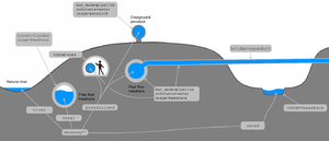
Domestic or industrial usages of water requires sometimes to channel it through tunnel=* or man_made=pipeline.
It mostly refers to waterway=canal or waterway=pressurised. You can choose the appropriate value as follows:
| Free flow | Pipe flow | ||||
|---|---|---|---|---|---|
| Man made | Open air | culvert | flooded tunnel | pipeline | |
| canal (useful water) | pressurised | ||||
| ditch | |||||
| drain (superfluous water) | |||||
The only questions to ask to get the difference between Free flow and Pipe flow is Does water flow inside a closed space and can air get inside the conduit? If yes, the water can't be pipe flow and you'll have to choose for an according waterway=* value from the table.
Even if waterway=* values can be refined or replaced, it would be really nice to preserve the distinction between free/open channel and pipe flow features. It's really important data for water management and resource planning.
When mapping some human made water channeling features, remember to describe particular intakes and outfalls with inlet=*, outlet=* and man_made=outfall.
Storage
Water storage refers to any activity designed to retain variable amount of water for a particular purpose including human drinking, agriculture, hydro power or emergency/fire fighting.
Useful tags to see
- landuse=reservoir or water=reservoir
- man_made=water_tower
- man_made=reservoir_covered
- man_made=storage_tank
- emergency=water_tank
- water=basin or landuse=basin
- basin=*
Most of them deal with actual storage structures. OSM could deserve an unified tagging scheme to give a better insight of water volume and the purpose of such storage.
Examples
Larger features include waterway=canals, and locks, landuse=reservoirs and waterway=dam, man_made=pipelines, man_made=water_towers, man_made=wastewater_plants, and man_made=water_works
It is also possible to tag amenity=drinking_water points where the public can access clean drinking water, and amenity=fountains.
