WikiProject Belgium/open streetlevel imagery/starters manual
Starter’s guide GoPro Max for OSMbe
Backup policy
Please upload your images to Mapillary (see below) AND keep a backup. In the future we intend to share the images on other platforms as well. You can send the backup on SD-cards by snailmail to Thibault.
Folder naming convention:
- start with a username of your choice
- create a subfolder with the device name (GoPro Max)
- create a subfolder with the date of your session and a very short description of your ride, like "20221231 cycle ride Dendermonde" (this is just for convenience, not really needed)
This implies you don’t have to worry about the GoPro creating duplicate folders, as they are in different folders anyway.
Don't start before you've read this
Here are some important things to keep in mind before you go out!
- Mind your head! It is incredibly easy to forget you are higher than usual. Especially branches can sneak up on you.
- The lenses are quite soft and sensitive. Always put the protectors back on after use! Only clean with a soft cloth, like for glasses. Check often if the lenses are still clean. Lens protectors exist, but aren't great for image quality.
- Consider adding a little rope to your setup, so that if your camera tries to fall, there is still a backup.
- Give the GoPro Quik app a shot. You can then "remote control" your device with your smartphone. This can be handy if the device is out of reach. You can also experiment with Voice Commands for the same goal.
- When connecting to GoPro Quick, date-time should be automatically fixed. But do check your datetime often, because otherwise you might have photos "from the distant past" or "from the future" (and you can't upload those).
- Horizons are hard to get straight, especially on a bike. Experiment a bit before doing big shoots. The GoPro Quick preview can be helpful, but only when the camera is NOT set to 360. Make sure your bicycle helmet is stable and doesn't move to one side. Take in account how you will actually sit on the bike when straightening things. Be mindful of your head movements - look around too much and your photo's will not be aligned properly.
- Make sure the screws are nice and tight. The camera might shift if it is not secured well.
- Save your data after every shoot, and format your SD card regularly.
- To save your data, the quickest option is to remove the SD card and use an SD card reader. Copy, don't move your files (moving has a higher risk of error and data loss). After copying simply format the SD card with the GoPro.
- One battery will last about two hours, less in winter, more in summer. Plan accordingly.
- If you use the dual battery charger, make sure the light is on. Best to plug the device in first, and put the battery in after.
- Double-check your settings: many people have come back from a long shoot having accidentally shot traditional images or video, instead of 360 timelapse.
- If the settings are correct, lock the screen.
Actual starter's guide
Basic necessities:
- GoPro Max
- Mount for car, helmet, stick
- 2 charged batteries & charger
- empty SD card
- card reader for SD card
Turn on the GoPro with the power button, on the left. It doesn't always work from the first try. If it keeps failing, remove the battery for an instant.
Make sure the GPS pin-drop is activated. Swipe back up to return to start.
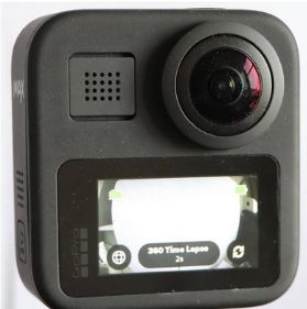
Starting screen
- To change Mode, swipe left/right or tap the power button: options are 360 Time Lapse (that's what we need!), 360 Video & 360 Photo
- Globe: when visible, you will be shooting in 360 (so with the two lenses)
- To check the horizon, tap the Globe to switch to 1 camera. Try and get the horizon flat and centered, both to the front and the back. Here you can also set which lens is to the front (icon with two arrows in a circle). Make sure it is correct, then switch back to 360.
- In 360 Time Lapse mode, set the format to Photo. The fastest interval is 2 seconds. Pick that. If you see a number lower than 2s, you are in burst mode and need to change.
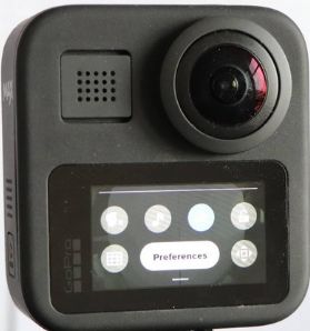
Preferences Swipe down to see Preferences and check these:
- Connections
- Wireless Connections Off (to save battery)
- General
- Time: try to get it to the exact second correct (e.g. with https://www.am-pm.nl/de-juiste-tijd
- Date: make sure it is today
- Dateformat: DD/MM/JJ
- DefaultMode : LastUsed (you can just start shooting like you last did)
- Voice control
- Voice control Off (unless you intend to use it!)
- Touch screen
- Regional
- GPS on (essential!)
- About
- Camera info: software version 02.00
- Reset
- Format SD card (do this often to prevent data loss caused by SD card crashes. Careful: this deletes all images on the SD card)
Shoot!
Start and stop with the red button on top Switch off device: 3s on on/off button
After the ride
- Put the SD card in a card reader and copy the data from the DCIM folder. There will be a lot of subfolders. See the backup instructions for suggestions on how to organize the files. After you copied all the files, put the SD card back in and format the card.
- You can consider improving the alignment of the images with GeoSetter. Especially in urban context this can be useful. In general, the GPS isn't bad.
- Send the images to Mapillary, see below.
Mapillary access
You can use your personal account, but make sure you associate your upload to the correct organisation. We have organizations to track projects or individual cameras. For OSM.be camera's, we will add you as a contributor to OSM Belgium Official Cameras Organization account. Send your Mapillary username to Joost so he can add you to the OSMbe organisation. This means you can just use your regular account, but the images can still easily be tracked together. Don’t forget to say the images are with the Organization at every upload.
If you don’t have an account yet:
- go to https://www.mapillary.com/app/
- choose Sign up (top right)
- email address nor username can already be in use. Note that it is impossible to change the email address later
''Software''
- To improve positioning of images: https://geosetter.de/en/download-en/
- Mapillary Uploader for Desktop: https://www.mapillary.com/desktop-uploader
- simple program to upload images
- make sure you activate the option to calculate orientation based on the next image
- Mapillary Command Line interface: https://github.com/mapillary/mapillary_tools
- requires Python
- it's a little complicated to get started with, but you can upload a LOT of images in a simple way.
- Example command for preparing images:
mapillary_tools process "c:\mapillary\ready for upload" --interpolate_directions --cutoff_distance 100 --skip_process_errors
You might want to add--duplicate_distance 3 --duplicate_angle 360
So images closer than 3 meters apart will automatically be skipped. Disengage the use of the angle of images, as we are using 360 images. - For the OSM Belgium organization, the actual upload goes with
mapillary_tools upload "c:\mapillary\ready for upload" --user_name "your username" --organization_key "2984883051800045" - The folder may contain dozens of subfolders.
- Mind that the folder name should NOT end in
\.


