WikiProject Cartography/Waterways
Cartography oriented River tagging preservation Project
Cartography oriented River tagging preservation project aims to preserve the original and better (from Cartographic/GIS perspective, see reasons below) tagging of waterways (and waterbody objects in general).
Please be aware of the Automated Edits code of conduct; large-scale edits should only be done with the consent of local mapping communities.
Background on Cartographic River Tagging Schemes
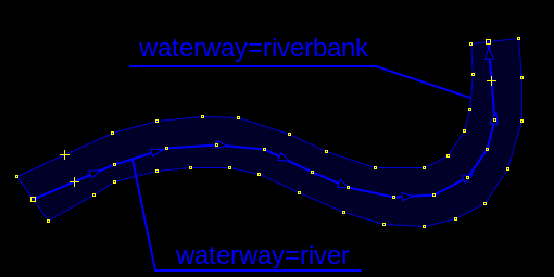
The earliest OpenStreetMap tagging schemes for rivers had two tags: waterway=river for the tagging ways representing the path of the river, and later waterway=riverbank, which was used to tag the banks (edges) of the river. This tagging system evolved over time, and mappers began connecting the two riverbanks into closed polygons, and today waterway=riverbank is used to tag the areas of rivers. This way we have two one class tags to tag one class of objects - waterways - one for centerline, another for boundaries - very logical from GIS perspective and essential from Cartographic perspective.
It is of utmost importance that these waterway tags are not mixed with other waterbody object tags, such as lakes, reservoirs as those have a totally different semantic, ontological meaning, have different position in data analysis as well as totally different symbolisation rules.
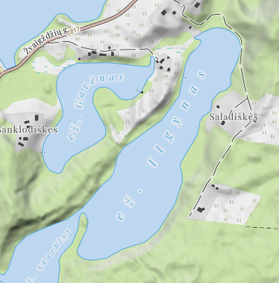
To be more specific, one of the most obvious reasons why riverbank tagging should not be mixed with waterbody tagging is its symbolisation. Waterbodies (natural=water - natural lakes and landuse=reservoir - human made reservoirs) are the substance of the object, they get the name from the name tag on it:
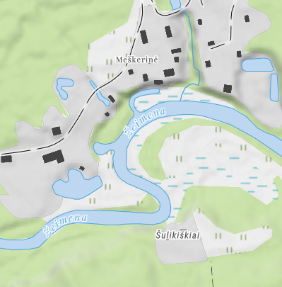
While for rivers, name comes from the centerline - waterway=river object. The reason for this that rivers have a very important attribute - direction of flow which traditionally has always been depicted on maps:
In 2011, the proposal water details was approved, creating the water=* key, which provided additional detail to areas tagged natural=water. That proposal approved the new tag water=river (+natural=water) and as stated by the people who have actually voted and as stated in the proposal it was never supposed to be as a wholesale replacement for the original waterway=riverbank. In the following years this new tagging was totally ignored (not getting even a percentage of usage). Until coders of iD editor acted without doing any analysis: without getting the numbers, without looking into cartographic/GIS points and made the new (and mostly unused) schema not only the only one, but also started misguiding mappers about "deprecation" of original waterway schema and replacing original tagging (thus damaging OpenStreetMap data). We can therefore see that uptake of new waterway schema is not a concious decision by mappers but rather an outcome of lack of analysis on the side of iD coders.
As considerable number of years have passed since this damage has been done, in order to increase the cartographic/GIS value of water feature tagging across the database, and maintain alignment with the original standard, the following procedures are provided as a guide to mappers wishing to modernize river tagging in their area.
Procedure
This page documents the process of cartographically improving river tagging - waterway=riverbank instead of natural=water + water=river.
Step 0 Ensure that you have the support of the local mapping community. Also, it is recommended to upload changesets periodically for a large modernization job.
- See the OSM Community Index to learn where the local mapping community can be contacted in a particular area.
- Here is a suggested message for reaching out to a local OSM community:
I'm working on a project that aims at improving the river data in OSM. The main aim of the project is fixing various issues like duplicated nodes, overlapping water areas, crossing ways, and using the original, cartographically better waterway=riverbank scheme. Would you support such a project in order to fix geometry errors and update tagging on <location>'s rivers? You can learn more about this project and what exactly is being done [1]. Let me know if you have any questions.
Improving riverbank tagging in JOSM.
[out:json][timeout:2500];
{{geocodeArea:"Rhode Island"}}->.a;
(
nwr["water"="river"](area.a);
);
(._;>;);
out skel qt;
Alternately, use a bounding box:
[out:json][timeout:2500];
{{geocodeArea:"Rhode Island"}}->.a;
(
nwr["water"="river"]({{bbox}});
);
nwr._(area.a);
(._;>;);
out skel qt;
Channge the taggins a appropriate to waterway=riverbank.
- Press Ctrl+F and search for
water=river - Delete the
water=riverandnatural=watertags from the selection - Set
waterway=riverbank
Do not forget to upload your changes!
Progress
See Taginfo map of water=river instances.
See also
- WikiProject Waterways/River modernization - A project to increase river details and update the tagging scheme to natural=water + water=river or other water=* tags where appropriate. This is a moderately controversial project about removing valid water tags (tags which have never ever been deprecated) which was started by Brian Sperlongano after it was agreed that there should not be any massive removals of non-deprecated water tags. See the most recent (but not the only one) long discussion here [2]


