Winnenden
Jump to navigation
Jump to search
| V・T・E |
| Länge: 48.878, Breite: 9.3962 |
| Zur Karte von Winnenden 48°52′40.80″ N, 9°23′46.32″ E |
| Karte bearbeiten |
|
| Weitere Links: |
| Verwende diese Vorlage für deinen Ort |
Winnenden ist eine Stadt in Rems-Murr-Kreis, auf der Breite 48°52′40.80″ Norden und der Länge 9°23′46.32″ Ost.
DIESE SEITE IST KOMPLETT VERALTET UND SOLLTE VOLLSTÄNDIG NEU ERSTELLT WERDEN
Current work at the map data of Winnenden
This page is intended for the coordination of the work on different parts of the town as multiple people work simultanious at the map data.
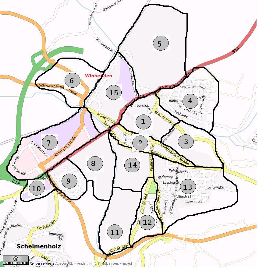
map of the areas of Winnenden
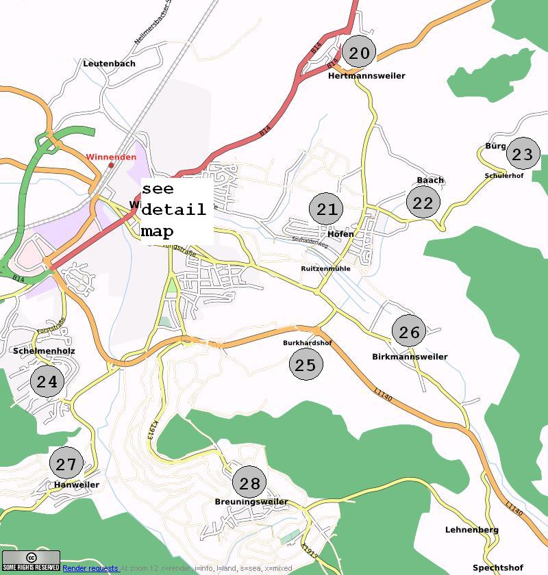
map of the suburbs of Winnenden
overview of mapping work at Winnenden
referenced by the pictures above
| Area | Name | GPS track | roads | road names | POIs | comment |
|---|---|---|---|---|---|---|
| 1 | Innenstadt | ? | ? | ? | ? | GPS tracks have to be captured by bike or by foot |
| 2 | Südliche Innenstadt | MichaelK: 90% | MichaelK: 90% | MichaelK: 90% | ? | POIs are missing, check required |
| 3 | Friedhof, Ostteil | ? | ? | ? | ? | |
| 4 | Wohngebiet Pfützen | MichaelK: 90% | MichaelK: 70% | MichaelK: 0% | MichaelK: 0% | MichaelK: work in progress, surrounding tracks are almost all missing |
| 5 | Wohngebiet Hungerberg | ? | ? | ? | ? | |
| 6 | Westlich Bahnlinie | ? | ? | ? | ? | |
| 7 | Max-Eyth-Straße | MichaelK: 90% | MichaelK: 70% | MichaelK: 0% | MichaelK: 0% | MichaelK: work in progress |
| 8 | Wohngebiet Horeuschstaße, etc. | ? | ? | ? | ? | |
| 9 | Wohngebiet Lange Weiden | MichaelK: 90% | MichaelK: 70% | MichaelK: 0% | MichaelK: 0% | MichaelK: work in progress, surrounding tracks are almost all missing |
| 10 | Industriegebiet Linsenhalde | MichaelK: 90% | MichaelK: 70% | MichaelK: 0% | MichaelK: 0% | MichaelK: work in progress |
| 11 | Wunnebad, Sportanlagen, BZ2 | MichaelK: 50% | MichaelK: 40% | MichaelK: 0% | MichaelK: 0% | MichaelK: work in progress |
| 12 | Stadtgarten, etc | MichaelK: 98% | MichaelK: 95% | MichaelK: 95% | MichaelK: 50% | MichaelK: work in progress |
| 13 | Wohngebiet Kesselrain | nonchmaltobi: ?% | nochmaltobi, nubok: ?% | nochmaltobi, nubok: ?% | ? | tracks arround are missing |
| 14 | Paulinenpflege, PLK | ? | ? | ? | ? | GPS tracks have to be captured by bike or by foot |
| Stadtteile | ||||||
| 22 | Baach | ? | ? | ? | ? | minor work donne by MichaelK |
| 26 | Birkmannsweiler | ? | ? | ? | ? | |
| 28 | Breuningsweiler | MichaelK: 100% | MichaelK: 100% | MichaelK: 100% | MichaelK: 100% | can be considered to be finished including surrounding tracks, trackgrade has to be added to surrounding tracks. |
| 23 | Bürg, Schulerhof | ? | ? | ? | ? | |
| 25 | Burkhardshof | MichaelK: 70% | MichaelK: 70% | MichaelK: 70% | MichaelK: 0% | tracks around are missing |
| 27 | Hanweiler | MichaelK: 70% | MichaelK: 70% | MichaelK: 0% | MichaelK: 0% | MichaelK: work in progress |
| 20 | Hertmansweiler | ? | ? | ? | ? | |
| 21W | Höfen West | MichaelK: 100% | MichaelK: 100% | MichaelK: 100% | MichaelK: 50% | MichaelK: work in progress |
| 21E | Höfen East | MichaelK: 100% | MichaelK: 70% | MichaelK: 10% (present as sketch on paper) | MichaelK: 10% | MichaelK: work in progress |
| 24 | Schelmenholz | MichaelK: 70% | MichaelK: 70% | MichaelK: 0% | MichaelK: 0% | MichaelK: work in progress |


