2014 Gaza Strip
|
2014 HOT project for the Gaza Strip General informationFor coordinating future interventions and humanitarian assistances, the Middle East & Near Africa Shelter Cluster in partnership with Terre des hommes Lausanne, decided to launch the digitalization of Gaza buildings, in close relation with OpenStreetMap contributors, based on an imagery of the July 6, 2014. The results will be essential to fine tune existing UNOSAT damage assessment and to provide to the humanitarian community a precise baseline for analysis related to destruction and population displaced. The baseline will be completed later on with more exhaustive damage assessment and results will be available for GIS expert and the humanitarian organization providing gaza field assistance. A high-resolution Pléiades satellite imagery of Gaza, taken on July 6th, 2014, will be used with a license that allows its use for tracing in OSM. It has been made available on OpenStreetMap France server. If you want to participle go to the links (HOT Tasking manager): http://tasks.hotosm.org/project/611# About OpenStreetMapOpenStreetMap offers an online map (and spatial database) which is updated by the minute. Various online maps are based on OpenStreetMap including Navigation tools such as OSRM. Tools and services allow data extracts for GIS specialists, Routable Garmin GPS data, Smartphone GPS navigation, and other device-compatible downloads. With an internet connection, regular syncing is possible with open access to the community contributed data as it comes in, with OpenStreetMap's bulk data downloads ideal for use offline. In addition, maps can also be printed to paper. |
Statistics about effort made
- As of July 1 - Request from the shelter cluster to help for methodology
- As of July 2 - After the need analysis, we decided to do pre building base on image from the 6 july 2014
- As of July 3 - We put Pleiades image on OpenStreetFrance Server
- As of July 4 - OpenStreetMap activation via the Hot tasking manager http://tasks.hotosm.org/project/611
- August 27 - Total in OSM 94 796 buildings
- September 15 - Total in OSM 120 000 buildings
To compare before and after :
http://pierzen.dev.openstreetmap.org/hot/leaflet/OSM-Compare-before-after.html#15/31.5288/34.4658
http://www.ochaopt.org/documents/ocha_opt_sitrep_26_08_2014.pdf
Advice for the digitalisation
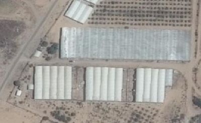
| Tracing buildings with oblique images ! | |
|---|---|
| Picture 1. Tag:building=greenhouse |
THIS IS NOT A BUILDING, BUT A GREENHOUSE. We don't need to digitize it. |
For Digitizing the pre-crisis buildings in OSM (Gaza Strip case), we recommend to install and use the Building plugin in JOSM. A LearnOSM tutorial describes in detail the use of this Plugin.
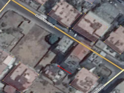
Note that the imagery is oblique and that in urban areas the multi-floors buildings look larger that they are in reality. When tracing, you have to take this into account. You must place the polygon that represent the building at the building footprint (see image 2.a). In this same oblique image, the building looks like its footprint goes up to the middle of the road. In fact it is not and you must correct taking into account this perspective effect.
To assure that you trace the correct outline and properly locate the building:
- Simply trace the outline of the roof using the Building plugin ( http://wiki.openstreetmap.org/wiki/JOSM/Plugins/BuildingsTools ). Press B to start tracing, trace the building, then press S to stop the Building function. Then, move the outline to the base of the building. Since the roof and base of a building generally have the same shape, you now have a good outline.
| Image 2.a |
Data updates
Thanks to datendelphin contributor and GeoFabrik who update these files every night.
| OSM Format | ShapeFiles for GIS softwares | Offline navigation on small devices |
|---|---|---|
|
|
|
Tools, adaptation and services
The various OSM developers communicate over internet through various communication channels. In 2013 they implemented the new Humanitarian Map Style, a map more adapted to humanitarian actions. This map, hosted by OpenStreetMap - France, is integrated in various online map tools.
The Tasking Manager and the JOSM editor are essential parts of this Activation. As new imagery are available, new jobs are added to the Tasking Manager. It has allowed HOT to coordinate efforts of mappers around the world. Some days there were more then 200 simultaneous mappers registered on the Task Manager and editing mainly with the JOSM editor. Online editors are also used for less intensive mapping. LearnOSM.org offers learning material for beginners and more advanced mappers.
How you can contribute to this activation
Learn to Map
- Most of our volunteer needs are for remote OSM contributors, visit LearnOSM.org to get started.
Mapping Priority
- Please choose from highest priority first
| Job No. | Priority | Location | What to map | Imagery source | Task mapping status | Task validation status |
|---|---|---|---|---|---|---|
| Job 611 | High | Gaza | roads and residential | Pleiades | 63 % | 19 % |
Available imagery
How to add to JOSM from the tasking manager
It's easy to add special imagery to JOSM from the task manager jobs, where an imagery URL is provided within the task manager. Clicking the URL should trigger JOSM remote control to add the new imagery as a layer. For more details see OSM Tasking Manager/Setting up JOSM
Pleiades
Pleiades from CNES 2014, distribution Airbus Defense and Space coverage.
To access the imagery in JOSM, choose Edit / Preferences / WMS - TMS. Update the list of available suppliers, select "Gaza Strip, Pléiades,20140706", and activate it. It will then be available in your Imagery menu.
The TMS URL for JOSM is: tms[22]:http://imagery.openstreetmap.fr/tms/1.0.0/gaza_pleiades_20140706/{zoom}/{x}/{y}
(Otherimagery sources)
- Add sources and relevant information on imagery (broken into source) here...
Potential datasources
- Add potential data sources here...
Historical maps
- Provide links to historical maps of the impacted area here...
- Historical maps, and other out-of-copyright sources can be rectified and used as a layer through MapWarper
Mapathon events
- Add your event here...
Past events
- Add past mapping events/projects in the impacted area here...
Contributor statistics for this activation
- Add links to contributor stats for this activation here...
Media coverage
- Provide relevant links here...
Other links
- Provide relevant links here...


