Day use only
Signs bearing the phrase “day use only” are sometimes used to indicate that a feature is open to the public only during daylight hours, but is closed at night.
Day use only areas can be tagged using a conditional access restriction. The time range for which the restriction applies can be expressed using the opening hours syntax. If explicit times are not posted, sunset-sunrise is a reasonable interpretation.
In nearly all cases, signs indicating "day use only" are also intended to prohibit camping (though this isn't always stated explicitly). When this is the case, the feature should also be tagged camping=no.
Be careful to only apply these tags to the area indicated by the sign. Signs sometimes indicate a small area where overnight use is not allowed within a larger area where it is permitted (for example a day-use-only picnic site within a larger campground).
Examples
| A simple sign, found in the backcountry. No specific times are posted. The area should be tagged access:conditional=no @ (sunset-sunrise) and camping=no. If the boundary of the area isn't clearly marked, the tags can be placed on a node instead. | |
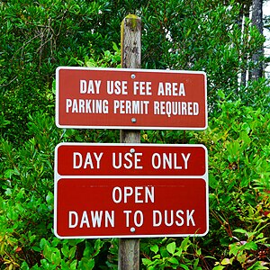
| This sign, found at a picnic area in a state park, says both "day use only" and "open dawn to dusk". The picnic area should be tagged access:conditional=no @ (dusk-dawn) and camping=no. | |
| The sign at this picnic area identifies specific opening hours. The picnic area should be tagged access:conditional=no @ (21:00-06:00) and camping=no. |
Usage count (Taginfo)
Usage counts for the specific tag access:conditional=no @ (sunset-sunrise):


