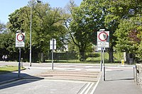
Tag:fire_path=yes
| Description |
|---|
| An area kept clear of obstructions which would allow access in emergencies by fire-fighting vehicles. |
| Group: emergencies |
| Used on these elements |
| Useful combination |
| Status: in use |
| Tools for this tag |
|
A fire path is an area kept clear of obstructions which would allow access in emergencies by fire-fighting vehicles, and other high-wheelbase vehicles with robust suspension. They differ from service roads designated for emergency vehicles in that they are usually not engineered as a highway.
In Britain they usually have distinct road markings preventing parking in front of the fire path, and may have additional measures to prevent other types of vehicles using the route (such as high profile paving blocks). Often installed in residential areas with an older pattern of streets where some have been blocked to reduce through traffic, or in Radburn layouts where such paths greatly reduce access time. In these cases there may be pedestrian and bicycle access alongside or within the fire path.
Examples
Tagging
A typical fire path consists of the following elements:
- The fire path itself
- Block paving barriers to deter usage by ordinary vehicles, usually a pair adjacent to the sidewalk of each side of the fire path.
- Distinct painted road markings, showing a no parking area and the words "FIRE PATH" on either side of the route.
- A cycleway 'gutter' (usually with a no motorvehicles sign) and a footway.
In some cases an additional barrier, such as a lift gate may also be present.
In many cases when the fire path is clearly engineered as a highway, highway=service with service=emergency_access may be sufficient (see second example). In other cases, the accessibility is mainly enforced by ensuring obstructions are not present (see first example). The tag fire_path=yes can be used on the appropriate way to indicate this. Use existing signage to determine appropriate access tags: see the two examples.


