Import CAR WRI Data
Back to Central_African_Republic wikipage
| Description | Osm Import of geographic data in Central African Republic |
|---|---|
| Author | EUROSHA project |
| Source | WRI (World Resources Institut) |
| Date | 28 Mars 2013 |
| Permission | ODbL 1.0 / DbCL 1.0 / CC-BY-SA 2.0 |
Goals
This is the Import for Central African Republic done as a part of the EUROSHA project. It aims at including the geographical data released by the WRI (World Resources Institute) in the framework of the Central African Countries Import into OSM. It is processed by a specific team discussing and sharing the methodology so that the data is processed on a consolidated way. If you want to be part of it, please contact sev_hotosm
Schedule
- Preparation, discussion, technical aspects - end of March 2013
- The Import of the road network and the habitated places - expected in April 2013
Import Data
Data description
To fill the data gap in CAR, WRI signed an agreement in 2007 with the MEFCP to strengthen the government’s mapping and geo-spatial monitoring capacity, integrate forest sector data, and disseminate information to all relevant actors working in the forest industry.
Key Themes and Data Sets
- Forest Land Allocation - Collection of maps, overview of the different types of government forest land use allocations.
- Roads – Overview of logging and transportation infrastructure, as well as the network of public roads in CAR.
- Production Forests - Information on the status of logging permits, timber volume figures, management plan status, and annual harvestable areas within logging permts.
- Protected Areas - Location of protected areas in CAR.
The dataset can be found at the following links :
Background
Main pages: http://wiki.openstreetmap.org/wiki/Central_Africa_Import
and http://wiki.openstreetmap.org/wiki/WikiProject_Central_African_Republic
Data license: ODbL 1.0 / DbCL 1.0
ODbL Compliance verified: YES
Type of license : CC-BY-SA 2.0
Link to permission : see http://wiki.openstreetmap.org/wiki/Potential_Datasources#Central_Africa , http://wiki.openstreetmap.org/wiki/Import/Catalogue
and http://wiki.openstreetmap.org/wiki/Central_Africa_Import
OSM attribution : http://wiki.openstreetmap.org/wiki/Contributors#WRI
Import Type
This data will not be imported automatically, it will rather be used as guide in mapping.
Data Preparation
Data Reduction & Simplification
The data will be adapted to the keys listed below, according to the OSM tags through a script.
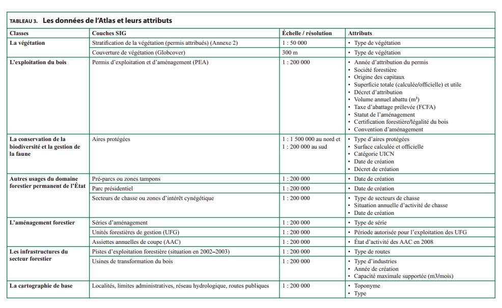
The authorization of the WRI gives permission to import all the date you can find back on http://www.wri.org/publication/interactive-forest-atlas-central-african-republic
Till now simplified data is only set up for the data which will be imported the first:
1. Lieux_habites
2. Hydro_Lin
3. Routes
4. Usines
Tagging Plans
This tables illustrate the proposition for converting the attributes of the WRI Data in OSM tags. Any suggestion or modification is well accepted and is to be proposed on the HOT list.
1. Lieux_habites
This data consists of locations of inhabited places and can be converted to OSM nodes.
| WRI Key | WRI value | OSM tag |
|---|---|---|
| NOM | name=* | |
| Code_1 | not to upload | |
| Type_habit | Campement | place=hamlet |
| Type_habit | Capitale d'Etat | place=city |
| Type_habit | Capitale régionale | place=town |
| Type_habit | Chef lieu de Sous préfecture | place=town |
| Type_habit | Village | place=village |
2. Hydro_Lin
This data consists of waterways and rivers and can be converted to OSM ways.
| WRI Key | WRI value | OSM tag |
|---|---|---|
| NOM | name=* | |
| NOM | NULL or 0 | not to upload |
| TYPE_HYD | Réseau tertiaire | waterway=river |
| TYPE_HYD | Réseau sécondaire | waterway=river |
| TYPE_HYD | Réseau principal | waterway=river |
| TYPE_HYD | NULL | not to upload |
3. Routes
This data consists of roads and tracks and can be converted to OSM ways.
| WRI Key | WRI value | OSM tag |
|---|---|---|
| NOM | ref=* | |
| NOM | NULL or 0 | not to upload |
| Route_Nom | name=* | |
| Route_Type | Unknown | highway=unclassified |
| Route_Type | Routes de plantation | highway=track |
| Route_Type | Routes secondaires | highway=secondary |
| Route_Type | Route régionale | highway=primary |
| Route_Type | Route principale | highway=primary |
| Route_Type | Route nationale | highway=trunk |
| Route_Type | Route bitumée | highway=primary |
| Route_Type | Piste piétonne | highway=footway |
| Route_Type | Piste forestière secondaire | highway=path |
| Route_Type | Piste forestière principale | highway=track |
| Route_Type | Piste forestière fermée | highway=track |
| Route_Type | Piste fermée | highway=track |
| Route_Type | Autre route publique | highway=unclassified |
4. Usines
This data consists of factory places and can be converted to OSM nodes.
| WRI Key | WRI value | OSM tag |
|---|---|---|
| Nom_societ | name=* | |
| Type_indus | Scierie | man_made=works |
| Type_indus | Scierie, déroulage | man_made=works |
Data Transformation
Data received are in shapefile. They will be converted to OSM-XML format and a service will be setup to serve the data into JOSM using the proposed tag scheme. Through OsmSharp a request will return data inside the requested tile and the HOT tasking manager will be adapted and updated in order to allow extra data to be loading into OSM in a semi-automated way. In this crowd-sourced way to verify and import the data, a link on the TM will allow the download of data just for the selected square of the job to be verified with already existing data and imagery.
This transformation is only used for roads and localities.
Data Merge Workflow
Team Approach
The importation dreamteam consists of three HOT ladies: fedebasa, Jorieke V and MorganeG with the technical support of Ben Abelshausen and sobzeros, member of OSM France.
References
The import will be discussed in the HOT list and in the in the import list..
Workflow
The road network
The data of the road network of the WRI will be used as guide in mapping. Avoid to delete existing data in OSM (only when it is really wrong), just add information!
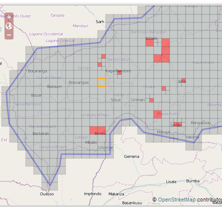
To coordinate the work, a Tasking Manager is created: http://tasks.hotosm.org/job/219
Follow the next steps to work with the Tasking manager.
1. To open the already existing data on OSM:
  - Open the latest version of JOSM on your computer.
  - Take a task in the tasking manager.
  - Click (in the tab 'Task')on the JOSM box .

  The normal layer with existing data on OSM will open in JOSM.
2. To open the data of the WRI on another layer there are two options:
  Go back to the Tasking manager, to the tab 'Task'

  A. Just click on the link provided and the data will automatically open on a new layer.
     (latest version of JOSM needed!)

  or:

  B. Click right on the other provided link (.osm) and click on 'copy link address'.
     Now go back to JOSM and click on 'file' and next on 'Open location'.
     Enter the URL you just copied, in the box which opend.
     Check the box 'Separate layer'.
     and the WRI data of the road network will be downloaded on a new layer.
At this moment you have two layers of data opened on JOSM. One layer with the existing OSM data and one with the data of the WRI. Use the data of the WRI layer now as a guide to map the roads on the layer with the already existing data on OSM.
Now verify by using the Bing imagery and the already existing OSM data. Please do not upload the WRI data, but use it as a guide for tracing OSM data. Copy the tags of the WRI data on the already existing data if it provides an added value. Please refer to Highway Tag Africa [1] for the tagging methodology regarding roads.
Here is an example made on this TM tile: 
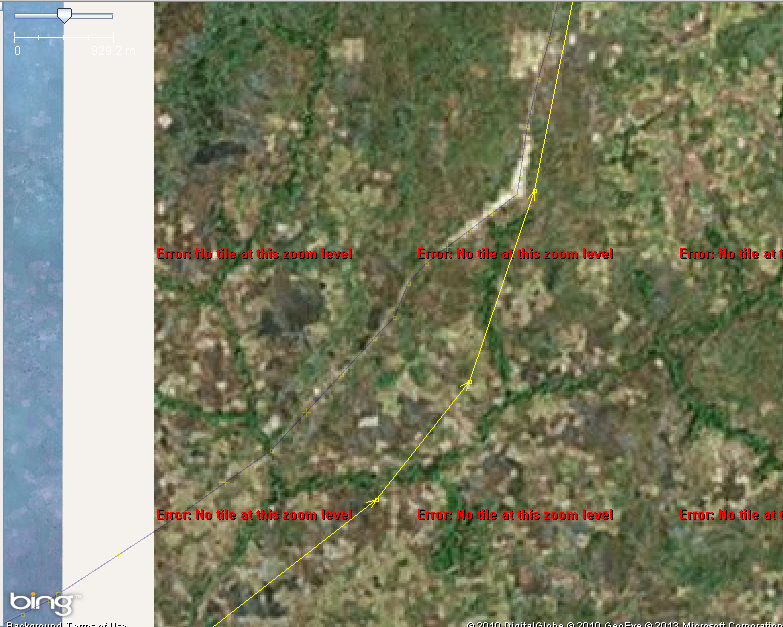
The overlapping between OSM and WRI shows the latter in quite inaccurate, but allows to find the missing roads and even more the missing tracks. It is even possible to trace them over the low res Bing Imagery (made from 30m resolution LandSat imagery), as seen below:
(Yellow is the WRI tracks, the one traced over Bing imagery is here in thin grey to make appear the track on the low res imagery)
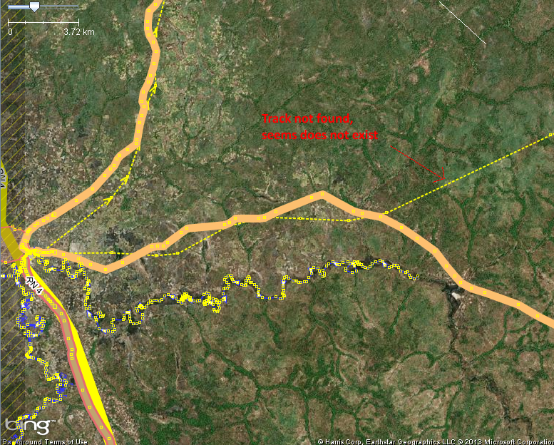
The resulting mapping is the one below. As you can see, there are some tracks that do not seem to exist on the field, even after having checked other imagery sources.
Now upload the OSM layer with this comment for your changeset: CAR, #hotosm-task-219, source=Bing,WRI
and mark your task as done on the Tasking Manager.
Reverse plan
In case of any trouble, JOSM reverter will be used.


