Jeography
| Jeography | ||||||||||||||||||||
|---|---|---|---|---|---|---|---|---|---|---|---|---|---|---|---|---|---|---|---|---|
| Author: | Sebastian Kürten | |||||||||||||||||||
| License: | GNU LGPL (free of charge) | |||||||||||||||||||
| Platforms: | Windows, Linux, and macOS | |||||||||||||||||||
| Version: | 0.0.1 (2016-09-26) | |||||||||||||||||||
| Language: | English
| |||||||||||||||||||
| Website: | http://jaryard.com/projects/jeography/ | |||||||||||||||||||
| Source code: | https://github.com/topobyte/jeography-gis | |||||||||||||||||||
|
Map viewer |
||||||||||||||||||||
| ||||||||||||||||||||
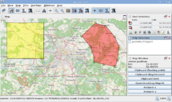
Jeography is a desktop OpenStreetMap viewer.
- Homepage: http://jaryard.com/projects/jeography/
- Mailing List: https://lists.openstreetmap.org/listinfo/jeography
It is written in Java with a Swing user interface. It can be run on all major desktop operating systems including Windows, Linux and macOS.
Features
- View map with configurable tile sources
- Select rectangular areas and perform actions on that
- Create polylines or polygonal selections
- Import polygon files and show them on the map
- Perform operations on geometric geographic features such as
- polygon union, intersection, difference
- line measuring
- calculating polygon buffers
- calculating the convex hull for a collection of objects
- Export geographic features to various output formats
- Offline search capabilities via downloadable place database
- Parser for various coordinate and URL formats
- Creating larger images from tiles
Installation
Release builds are available here: https://github.com/topobyte/jeography-gis/releases
Just download the latest JAR file and run it by double clicking it or executing this:
java -jar jeography-0.0.1.jar
Otherwise consult the homepage on how to obtain the source code and build / run the latest version from the sources.
Core libraries
Jeography is built around a core library that can be used for embedding map views into other software. It supports classic tile based map views with fixed zoom levels as well as views with stepless zoom. In the latter case the tiles for the intermediate zoom levels are obtained from higher/lower zoom levels by scaling down/up.
