Key:ref:penndot
| Description |
|---|
| Used for the PennDOT reference numbers of roads in Pennsylvania, according to the Location Referencing System. |
| Group: references |
| Used on these elements |
| Status: de facto |
| Tools for this tag |
|
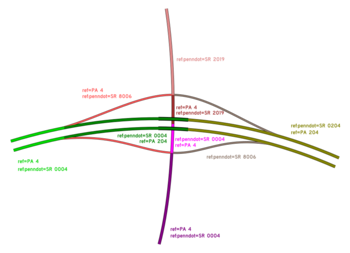
ref:penndot is used to tag ways with the internal reference numbers used by PennDOT for all state-owned roads in Pennsylvania according to the Location Referencing System. These numbers can be found in PennDOT's Type 10 Maps or the PennDOT One Map.
Note that this tag is not to be used for non-state federal aid roads (listed in TIRE under Jurisdiction 5), which usually have four-character designations beginning with a letter.
Tag history
From the TIGER import, many quadrant routes were tagged with name_1=State Route XXXX. Over time, many of these were moved to the plain ref=* key, as if they were signed traffic routes. In other places, the now-defunct key penndot_ref was used. Additionally, there was little consistency whether the values should be formatted "SR XXXX", "PA XXXX", "SRXXXX", etc. After a discussion on the [Talk-us] mailing list in 2015[1], it was decided that all quadrant routes would be moved to the new tag ref:penndot.
Some routes suffered abbreviation errors or other items covered in the TIGER fixup article, such as "Sun R" being interpreted as "Sun Rise".
Location Referencing System Description
Numbers are assigned as follows:
| Route number | Use | Notes |
|---|---|---|
| 0001-0999 | Signed traffic routes | Leading zeroes are often omitted on the markers. |
| 1001-4999 | Quadrant Routes | First digit varies based on rough county quadrant, going clockwise from northeast (1) to northwest (4). |
| 6001-6999 | Relocated Traffic Routes | Usually given the number of the former route with a leading 6. Also used for local/side lanes, HOV lanes, and roads under construction. |
| 7001-7999 | Turned back, abandoned, or null routes | Not generally used in tags, except for Pennsylvania Turnpike roads, which are given a leading 7. |
| 8001-8999 | Interchange ramps | Generally one number assigned per interchange, with all ramps having the same number. |
| 9101-9199 | Wyes and similar connector roads | |
| 9201-9299 | Rest areas | |
| 9301-9399 | Truck escape ramps | |
| 9401-9499 | Other roadways | Includes jughandles, miscellaneous connector roads, and rarely interchange ramps. |
Further information
Quadrant routes are the most common usage of ref:penndot, however it can be used for all state-owned roads.
Traffic routes are tagged with the full four digits, including all leading zeros (e.g. ref:penndot=SR 0095 for I-95). Where a concurrency exists, the SR designation is based on the lowest numbered route of the highest "priority" present. For example, US 22/322 in Dauphin County is SR 0022, while I-78/US 22 in Berks County is SR 0078. Interstate > US Route > State Route. There are two exceptions to this rule in the state: PA 581/US 11 near Harrisburg is SR 0581, not SR 0011 (perhaps a holdover from original plans for I-581), and the Pennsylvania Turnpike from New Stanton to Breezewood (I-70/76) is SR 7076, not SR 7070 (likely due to PennDOT not owning the Turnpike and wanting to keep their reference number for it as simple as possible).
For some roads, particularly duplicate numbers, the SR designation doesn't match up with the signed route. For example, due to the existence of I-283, PA 283 has the internal designation SR 0300, and is thus tagged with ref:penndot=SR 0300. Similarly, PA 380 is internally designated SR 0400 due to I-380. This is not always the case, however. After I-99 was completed, PA 99 became SR 0699. The northern segment of PA 97 is SR 0197, and other duplicate routes of the same type (e.g. US 422, PA 29) are given the same SR designation.
For portions of traffic routes not owned by PennDOT or given an SR 7xxx Turnpike designation, ref:penndot=none can be used. It can be assumed that any road with a ref:penndot tag other than none or one which starts with 7 is owned by PennDOT, and that any road without a ref:penndot tag, or tagged with ref:penndot=none or SR 7xxx is not owned by PennDOT.
Local/side lanes (such as the outer lanes of Roosevelt Boulevard in Philadelphia) as well as HOV lanes (along I-279 and I-579 in Pittsburgh) are given SR 6xxx designations, as well as routes under construction until they are completed. (For example, SR 6219 is used in Somerset County for the new US 219 expressway under construction. SR 6015 and 6061 are used similarly in Snyder, Union, and Northumberland Counties for the Central Susquehanna Valley Thruway.)
Despite being owned by the separate Pennsylvania Turnpike Commission, the Turnpike system roads are given reference numbers by PennDOT, all of which feature a leading 7. These are SR 7043, 7066, 7076, 7276, 7376, 7476, and 7576 for PA Turnpike 43, PA Turnpike 66, I-76 (mainline), I-276 (mainline), I-376, I-476 (Northeast Extension), and PA Turnpike 576, respectively. As mentioned above, the section of Turnpike carrying I-70 is still SR 7076. The tolled I-70 connector to Breezewood is given no number.
Interchange ramps are tagged as well. Where a ramp carries a signed traffic route, ramps still by far almost always are still designated with SR 8xxx, and not the traffic route's number. This applies to SR 9xxx ramps as well.
Tagging notes
- Note that the internal numbers don't always stop and start where signage or ramp configuration might imply. Often they change in the middle of interchanges under underpasses, or halfway along a ramp. Tag accordingly where possible.
- In the rare event that a physically undivided road is treated as divided in PennDOT's system, and given a separate SR designation in each direction, do not redraw the road as a divided road, instead use ref:penndot:forward=* and ref:penndot:backward=* according to standard way direction syntax. An example of this is this portion of US 11 near West Nanticoke.
- It's preferred to feature a space between SR and the number (e.g. SR 2032 and not SR2032), however many examples of the tag in the Philadelphia area still omit the space and should be corrected.
- If a road's SR designation is recently changed (e.g. due to a renumbering), the key old_ref:penndot can be used. For example, various sections of I-376 in Allegheny County could be tagged with old_ref:penndot=SR 0060, old_ref:penndot=SR 0279, etc.
Related tags
- ref=* for posted traffic routes as they appear on signs.
- unsigned_ref=* for any non-PennDOT unsigned designations for roads, such as the Txxx township road numbers.
External links
- County Type 10 Maps (doesn't display SR designations of signed traffic routes except in concurrencies)
- PennDOT Internet Traffic Monitoring System (iTMS) (requires Internet Explorer)
- Location Referencing System

