London/Summer 2008 Mapping Party Marathon/2008-06-11
This is a past event
This was the 6th Mapping Party in the Summer 2008 London Mapping Marathon series. We went South again.
When : Wednesday 11th June - Evening.
Where: South Bermondsey, South East London (normal map, unnamed streets map)
What happened?
Another fun meet-up. Cloudmade guys were out in force. We criticised weatherspoons at length, but enjoyed it anyway.
Who was there?
- TomChance but didn't make the pub meetup
Randomjunk-- after this morning's minor altercation between my bike, a pedestrian with a death wish, my face and the road I think I'll give it a miss... doesn't even count as a mapping accident.. damn.
Old ogrganisational info
Getting to South Bermondsey
South Bermondsey Railway Station (wikipedia) is located within Tube Zone 2. Oyster Card Season Tickets are valid, while Oyster PAYG is NOT valid.
The mapping area will be centered around South Bermondsey, but you might arrive from a different station and attack the cake from a different angle. Bermondsey and Canada Water are on the Jubilee line (north of the target area). Otherwise there's buses e.g. approaching from Elephant & Castle.
Surrey Quays and New Cross Gate are not an option, because East London line is closed. National Rail services are running from New Cross Gate.
The pub
The Surrey Docks [1]
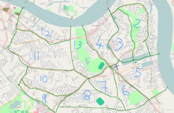
Cake Diagram
1. Smsm1
2.
3.
4. Harry Wood
5. Matt
6. Firefishy
7.
8.
9. TomChance - surveyed and all in the database :)
10.
11. Nickb
12. Welshie
13. Welshie
Promotion
- on upcoming.org
- added to this forum http://www.london-se1.co.uk/forum/read/1/89630
