MapOSMatic
| MapOSMatic | ||||||||||||||||||||||||||||||||||||||
|---|---|---|---|---|---|---|---|---|---|---|---|---|---|---|---|---|---|---|---|---|---|---|---|---|---|---|---|---|---|---|---|---|---|---|---|---|---|---|
| Authors: | Hartmut Holzgraefe] | |||||||||||||||||||||||||||||||||||||
| License: | GNU AGPL v3 (free of charge) | |||||||||||||||||||||||||||||||||||||
| Platforms: | Linux and Web | |||||||||||||||||||||||||||||||||||||
| Status: | Active | |||||||||||||||||||||||||||||||||||||
| Version: | (stable) (2023-02-02) | |||||||||||||||||||||||||||||||||||||
| Languages: | ||||||||||||||||||||||||||||||||||||||
| Website: | https://print.get-map.org/ (fork) | |||||||||||||||||||||||||||||||||||||
| Source code: | https://github.com/hholzgra/maposmatic (Frontend); https://github.com/hholzgra/ocitysmap (Renderer) | |||||||||||||||||||||||||||||||||||||
| Programming language: | Python | |||||||||||||||||||||||||||||||||||||
|
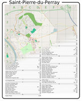
Mapnik render and streetlist |
||||||||||||||||||||||||||||||||||||||
| ||||||||||||||||||||||||||||||||||||||
MapOSMatic is a web tool to generate OpenStretMap based maps as printable PDFs, SVG, or single, untiled bitmap images. One of several tools for OSM on Paper. MapOSMatic can optionally add index of the streets and other features, indexed on a grid, and can generate multi page atlas-like booklets.
History
The then lead developers Thomas and Maxime Petazzoni gave a presentation: SotM 2010 session: MapOSMatic: City Maps for the Masses.
Unstable
From 2012-2017 the main website(maposmatic.org) has been unstable and rendering downtimes were frequent. In July 2017 the original website was taken down with this notice:
Sorry, we're not sure when MapOSMatic will be operational again. If you want to help put the project back on its feet, please reach out to us.
A new home
As of July 2017 the main project is down but a working fork is maintained by Hartmut Holzgraefe, hosted on print.get-map.org
Development
Main project (no commits since beginning of 2016):
Fork (active):
