Nottingham/West Bridgford

From OpenStreetMap Wiki
Jump to navigation Jump to search

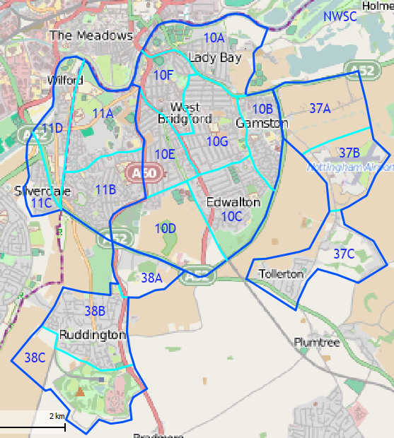
West Bridgford is a town on the outskirts of Nottingham. This page refers to a broader area defined in two 'cake slice' on the main Nottingham page and the adjcent villages and country parks.

This includes West Bridgford, Compton Acres, Abbey Park, Gamston, Edwalton, Wilford, Bassingfield, Tollerton and Ruddington are also included. The main purpose of this page is to provide more detail on mapping status, progress and issues, than is possible on the main page for the city.

On the main Nottingham page this area is part of Cake Slice 10 and 11 - slices 37 and 38 are not part of the main Nottingham cake slices.

Cakes Slices

West Bridgford.png

Colour and symbol legend

The status of each map region is indicated by a symbol, which describes the type of feature, and a colour, which indicates the completeness of that feature in a map region.

Usage

The status is displayed using a template Template:State

{{State|Key=progress}}
progress - 1/2/3/4/NA

Meaning of symbols

  • State Labelled.svg - Street names are labelled. This means that the map can be used to find an address - Key: l
  • State Housenumbers.svg - All housenumbers are present - Key: h
  • State Foot.svg - All footways are present - Key: fo
  • State Wheelchair.svg - All wheelchair access is present - Key: d
  • State Bike.svg - All cycleways, and field and forest roads suitable for bicycles are present - Key: b
  • State Car.svg - Roads for car traffic are present. One way streets and pedestrian streets are present. This means that the map can be used for car navigation - Key: c
  • State Transport.svg - All public transports are present (including name of the bus stop/station names) - Key: tr
    • State Stop.svg - All stop/station/harbour names are present - Key: ha
    • State Bus.svg - All bus lines are present (including name of the bus stop names) - Key: bu
    • State Trolleybus.svg - All trolley/guided bus lines are present (including name of the station names) - Key: ty
    • State Tram.svg - All tram lines are present (including name of the tram station names) - Key: tm
    • State Train.svg - All fast railway lines transports are present (including name of the train station names) - Key: tn
      • State U-Bahn.svg - All U-Bahn (subway in Germany) lines are present (including name of the station names) - Key: u
      • State S-Bahn.svg - All S-Bahn (regional commuter train in Germany) lines are present (including name of the station names) - Key: s
      • State Steamtrain.svg - All steam railway lines transports are present (including name of the train station names) - Key: st
    • State Ship.svg - All ship lines are present (including name of the harbour station names) - Key: sh
  • State Public.svg - All public institutions are present (Churches, sports facilities, venues, schools, hospitals, city hall) - Key: p
    • State emergency.svg - All emergency services (hospitals...) are present - Key: em
  • State Fuel.svg - All petrol stations are present - Key: fu
  • State Restaurant.svg - All restaurants and hotels are present - Key: r
  • State Tourist.svg - All tourist attractions are present - Key: t
  • State Nature.svg - All natural resources are mapped (e.g Water, Lakes and Woodland) - Key: n
Meaning of colours

Background colour Meaning Use for navigation To do value
State .svg The map needs checking, status unknown Availability unknown Please check (None)
State 0.svg The map contains no or little data Not to be used Please complete 0
State 1.svg The map contains partial data Limited usability Please complete 1
State 2.svg The map is largely complete (please describe missing data) Use with restrictions Please complete (missing data, streets etc.) 2
State 3.svg The map is complete (in the opinion of a mapper) Suitable for use Please check and correct any errors 3
State 4.svg The map is complete (verified by 2 mappers) ; please indicate Date when checked) Suitable for use Please update as needed 4
State X.svg This attribute does not exist in the mapped area (e.g. no petrol stations) Suitable for use Please update as needed X
The English translation is Editable here.
Cake Slice District Status Remarks Mapped / Checked by
10A Lady Bay Car (3/4)Labelled (3/4)Housenumbers (1/4)Bike (3/4)Foot (3/4)Wheelchair (0/4)Transport (2/4)Public (1/4)Fuel (X/4)Restaurant (1/4)Tourist (2/4)Nature (2/4) The area bounded by the River Trent, Adbolton Lane/Regatta May, Radcliffe Road and Trent Bridge
10B Gamston Car (3/4)Labelled (3/4)Housenumbers (0/4)Bike (3/4)Foot (2/4)Wheelchair (0/4)Transport (2/4)Public (1/4)Fuel (3/4)Restaurant (0/4)Tourist (X/4)Nature (1/4) The area bounded by the A52, Radcliffe Road, Gamston Canal and Gamston Brook
10C Edwalton Car (3/4)Labelled (3/4)Housenumbers (0/4)Bike (1/4)Foot (1/4)Wheelchair (0/4)Transport (2/4)Public (2/4)Fuel (0/4)Restaurant (0/4)Tourist (0/4)Nature (1/4) The area bounded by the A52, Gamston Brook, Beckside, Melton Gardens and the Old Dalby railway line
10D Sharphill Car (3/4)Labelled (3/4)Housenumbers (0/4)Bike (2/4)Foot (2/4)Wheelchair (0/4)Transport (2/4)Public (0/4)Fuel (X/4)Restaurant (X/4)Tourist (X/4)Nature (1/4) The area bounded by the Old Dalby railway line, the A52, Loughbourgh Road, Boundary Road. This area is mainly undeveloped at the moment but a large residential development is expected to commence construction in the near future
10E Musters (South) Car (3/4)Labelled (3/4)Housenumbers (0/4)Bike (2/4)Foot (1/4)Wheelchair (0/4)Transport (2/4)Public (0/4)Fuel (1/4)Restaurant (0/4)Tourist (0/4)Nature (0/4) The area bounded by Boundary Road, Melton Road, Loughbourgh Road
10F West Bridgford Car (1/4)Labelled (1/4)Housenumbers (0/4)Bike (2/4)Foot (2/4)Wheelchair (0/4)Transport (2/4)Public (1/4)Fuel (0/4)Restaurant (2/4)Tourist (1/4)Nature (1/4) The area bounded by River Trent, Wilford Suspension Bridge, Melton Road, Burleigh Road, Gordon Road, Rectory Road, Mabel Grove, Radcliffe Road
10G Abbey Park Car (3/4)Labelled (3/4)Housenumbers (0/4)Bike (2/4)Foot (2/4)Wheelchair (0/4)Transport (2/4)Public (0/4)Fuel (0/4)Restaurant (0/4)Tourist (0/4)Nature (1/4) The area inside all the other slices
11A Compton Acres North Car (3/4)Labelled (3/4)Housenumbers (0/4)Bike (3/4)Foot (3/4)Wheelchair (0/4)Transport (2/4)Public (2/4)Fuel (0/4)Restaurant (0/4)Tourist (0/4)Nature (2/4) Bounded by the Great Central Railway line, Rugby Road, Loughbourgh Road, River Trent
11B Compton Acres South Car (3/4)Labelled (3/4)Housenumbers (0/4)Bike (2/4)Foot (2/4)Wheelchair (0/4)Transport (2/4)Public (2/4)Fuel (0/4)Restaurant (0/4)Tourist (0/4)Nature (2/4) Bounded by the Great Central Railway line, Rugby Road, Loughbourgh Road, A52
11C Silverdale Car (3/4)Labelled (3/4)Housenumbers (0/4)Bike (2/4)Foot (2/4)Wheelchair (0/4)Transport (0/4)Public (0/4)Fuel (0/4)Restaurant (0/4)Tourist (2/4)Nature (2/4) The village of Silverdale
11D Wilford Car (3/4)Labelled (3/4)Housenumbers (0/4)Bike (2/4)Foot (2/4)Wheelchair (0/4)Transport (0/4)Public (0/4)Fuel (0/4)Restaurant (0/4)Tourist (2/4)Nature (2/4) The village of Wilford (to the west of the GCR)
37A Bassingfield Car (3/4)Labelled (3/4)Housenumbers (0/4)Bike (3/4)Foot (2/4)Wheelchair (0/4)Transport (0/4)Public (0/4)Fuel (X/4)Restaurant (0/4)Tourist (X/4)Nature (0/4) The village of Bassingfield and it's immediate surrounds
37B Nottingham Airport Car (1/4)Labelled (1/4)Housenumbers (0/4)Bike (0/4)Foot (0/4)Wheelchair (0/4)Transport (0/4)Public (0/4)Fuel (0/4)Restaurant (0/4)Tourist (0/4)Nature (1/4) Nottingham Airport and Tollerton Park
37C Tollerton Car (3/4)Labelled (3/4)Housenumbers (0/4)Bike (2/4)Foot (2/4)Wheelchair (0/4)Transport (0/4)Public (0/4)Fuel (0/4)Restaurant (0/4)Tourist (0/4)Nature (0/4) The village of Tollerton and it's immediate surrounds
38A Landmere Lane Car (3/4)Labelled (3/4)Housenumbers (0/4)Bike (3/4)Foot (3/4)Wheelchair (0/4)Transport (X/4)Public (X/4)Fuel (X/4)Restaurant (0/4)Tourist (X/4)Nature (2/4) The area to the east of Loughbourgh Road and it's immediate surrounds
38B Ruddington Car (2/4)Labelled (3/4)Housenumbers (0/4)Bike (2/4)Foot (1/4)Wheelchair (0/4)Transport (2/4)Public (0/4)Fuel (0/4)Restaurant (0/4)Tourist (0/4)Nature (1/4) The village of Ruddington
38C Ruddington Country Park Car (3/4)Labelled (3/4)Housenumbers (0/4)Bike (3/4)Foot (3/4)Wheelchair (0/4)Transport (2/4)Public (2/4)Fuel (0/4)Restaurant (0/4)Tourist (2/4)Nature (2/4) Ruddington Country Park and business park
NWSC National Water Sports Centre Car (3/4)Labelled (3/4)Housenumbers (0/4)Bike (3/4)Foot (3/4)Wheelchair (0/4)Transport (3/4)Public (2/4)Fuel (X/4)Restaurant (0/4)Tourist (2/4)Nature (2/4) Not show on the map - the National Watersports Centre, it's camp sites