OSMPal
If you know about the current state of affairs, please help keep everyone informed by updating this information. (Discussion)
| OSM Pal (OpenStreetMap Pal) Map Analysis Tool for .osm files | ||||||||||||||||||||||||||||||||||||||||||||||||||||||||||||||||||||||||||
|---|---|---|---|---|---|---|---|---|---|---|---|---|---|---|---|---|---|---|---|---|---|---|---|---|---|---|---|---|---|---|---|---|---|---|---|---|---|---|---|---|---|---|---|---|---|---|---|---|---|---|---|---|---|---|---|---|---|---|---|---|---|---|---|---|---|---|---|---|---|---|---|---|---|---|
| Platforms: | Windows, macOS, Linux, and Unix | |||||||||||||||||||||||||||||||||||||||||||||||||||||||||||||||||||||||||
| Status: | Broken | |||||||||||||||||||||||||||||||||||||||||||||||||||||||||||||||||||||||||
| Website: | https://wiki.openstreetmap.org/wiki/OSMPal | |||||||||||||||||||||||||||||||||||||||||||||||||||||||||||||||||||||||||
| Source code: | https://github.com/developingcountries/osmpal-nodes-basic/ | |||||||||||||||||||||||||||||||||||||||||||||||||||||||||||||||||||||||||
| Programming language: | Python | |||||||||||||||||||||||||||||||||||||||||||||||||||||||||||||||||||||||||
|
Map analysis tool of .osm files, helps find nearest and farthest POI's/tagged items, useful for offline environments. |
||||||||||||||||||||||||||||||||||||||||||||||||||||||||||||||||||||||||||
| ||||||||||||||||||||||||||||||||||||||||||||||||||||||||||||||||||||||||||
OSM Pal (OpenStreetMap Pal) is an OpenStreetMap tool to find nearest and farthest nodes of interest (POI's) from an .osm file using keywords. This tool runs in Python and it includes a simple geocoder so that you can enter a street address or zip/postal codes for analysis. It is also useful in remote areas when you need to analyze .osm files without internet connections.
This tool comes in 2 varieties:
- Text-only [1]
- Graphical (Requires matplotlib and networkx installed in Python) [2]
Download
Download the text-only tool:
Download the graphical tool:
Installation and Instructions
- For the text-only tool, follow instructions at https://github.com/developingcountries/osmpal-nodes-basic/
- For the graphical tool, follow instructions at https://github.com/developingcountries/osmpal-nodes-graphical/
Sample commands are:
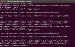
python osmpalnodesbasic.py nearest_node_tagged $'870 broadway' cafe (Prints the cafe that's nearest to 870 Broadway, in Mac or Linux).
python osmpalnodesbasic.py farthest_node_tagged "10010, new york" hospital (Prints the hospital that's farthest away from the zip code 10010 in New York, in Windows environment).
