Philippines/Featured images/2014
Jump to navigation
Jump to search
| Week | Image | Description | Global featured image? |
|---|---|---|---|
| Jul 27 | 
|
Ciudad de Victoria. Ahead of the 100th anniversary of the Iglesia ni Cristo, the church's centennial project, Ciudad de Victoria, is already well-mapped in OpenStreetMap. | |
| Mar 30 | 
|
HOT style map of Southern Tacloban. In response to humanitarian mapping in the wake of Typhoon Haiyan, the Humanitarian (HOT) map style was updated to show the status of damaged buildings. Shown is the HOT map of southern Tacloban showing buildings outlined in red (collapsed) and orange (damaged). | |
| Mar 23 | 
|
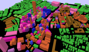
Quiapo buildings in 3D. A 3D visualization of the buildings in Quiapo, Manila showing building levels and color-coded by building=* values. This data was collected as part of the Quiapo Parish's disaster risk reduction management project with ESSC.[1][2] |
