Philippines/Featured images/2017
Jump to navigation
Jump to search
| Week | Image | Description | Global featured image? |
|---|---|---|---|
| Aug 14 | 
|
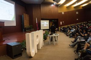
In congruence with the 40th anniversary of the UP (University of the Philippines) Mountaineers, the organization has held ""AkyatCon2.0"" (en: Climb Conference 2.0). User:Schadow1 and User:Banito_Pinoy has presented to over 100 attendees the importance of GPS Mapping and contributing to OpenStreetMap for the Philippine mountaineering community. About 67 hiking trails and over 231,000 kilometers of roads has already been contributed to OpenStreetMap and is compiled to GPS handheld device format by Schadow1 Expeditions. More information on AkyatCon at [1] | 
|
| Jul 3 | 
|
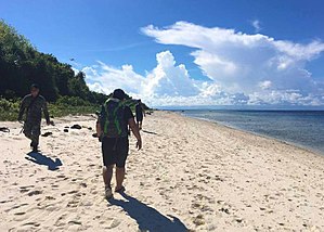
Tawi-Tawi Mapping Expedition With drone pilots, Marines, Navy and Army's Scout Rangers, User:Schadow1 organised a mapping expedition in southern Philippines for logistics, navigation, military operations purposes, and tourism. 1,957 data elements were added by the expedition.[2] | 
|
| Jun 5 | 
|
San Juan Mapping The OpenStreetMap Philippines community held a mapathon on May 29, 2017. This event was organized by User:GOwin as part of his MapAmore initiative and was hosted by the City of San Juan's Central Emergency and Disaster Operations Center (CEDOC). | 
|
| Mar 20 | 
|
DOST-Project NOAH Exposure Mapping. The Nationwide Operational Assessment of Hazards (NOAH) under the Philippines' Department of Science and Technology, coordinated a series of mapping sessions in the last 12 months that improved the map of Philippines. This data will be used in improving disaster management before, during, and after emergencies [3] | 
|
