Proposal:Stone=*
| stone=* | |
|---|---|
| Proposal status: | Canceled (inactive) |
| Proposed by: | Gruebel |
| Tagging: | stones=yes, bare_rock, scree |
| Applies to: | |
| Definition: | An editional subkey for some natural=* and landuse=* tags to mark that the area is littered with stones of different types. |
| Statistics: |
|
| Draft started: | 2021-05-05 |
| RFC start: | 2021-05-10 |
Proposal
The idea is to add a new subkey to some natural and landuse tags. This new subkey is used to mark areas that are littered with stones. There are three possible values: stones=yes, stones=bare_rock and stones=scree. The value provides information about what stones are present.
This subkey will be used mainly in mountains to significantly improve the landscape rendering and orientation. So it can be used with natural=grassland, landuse=meadow, natural=heath, natural=scrub and natural=wood or landuse=forest. The tags are sorted according to their importance and occurrence.
The current situation with grassland and stones
In the current situation, mappers have several bad options to map grasslands that is littered with stones:
1. They can either map the complete area with natural=grassland or natural=bare_rock and natural=scree. The problem here is the separation to exactly these areas.
2. They could map every stony area with natural=bare_rock or natural=scree. The problem here is the very large effort and the unnecessary amount of data. Also often it is impossible to do, as there are to just to many distributed stones. Furthermore scree has the potential to change over time.
3. The tag natural=fell, but the problem is that fell is a very wide term, so it includes bare stone, grassland and heath. In the german wiki page there is a good figure. This is also noticeable in the discussions about rendering natural=fell (see #545). The same problem exists with natural=tundra.
4. Not tag it at all. This is the most common approach and can be seen all around the Alps. It should be clear that not tagging for areas this large is bad.
Rationale
This subkey could greatly improve the representation and rendering of nature in mountains. It would also be a big improvement for the orientation of hikers. Furthermore it should end the discussions about rendering natural=fell and natural=tundra (see #545) as these tags would only give geographical and naming information and should not be rendered in normal map views.
In mountains many regions above and around the tree line could be easily expanded. So for example in the Alps, Scandinavia, ...
In addition, nearly no existing tags would have to be changed, since it is only a subkey. Also in most areas where the combination of natural=grassland and stones=* would make sense no nature has been drawn in yet. This is probably due to the problems with the current situation as nobody really knows that the best way to map these areas are. This tag should change that. In already mapped areas the key could be easily added in appropriate places. Also some natural=fell should be retagged to be natural=grassland + stones=scree or something similar.
A new subtag is more useful as new values for the natural=* and landuse=* tags. As this subtag can easily be added or removed form different tags. Also it is better as the important combinations can be achieved without the introduction of multiple new values for natural=* and landuse=*. In addition, existing areas are hardly changed. This makes the use of the data easy. Existing systems using the data continue to function and can be extended with minimal effort.
Tagging
Should be tagged alongside areas ![]() with tags like: natural=grassland, landuse=meadow, natural=heath and natural=wood or landuse=forest. If no stones=* tag is given it should act like before the subkey was introduced.
with tags like: natural=grassland, landuse=meadow, natural=heath and natural=wood or landuse=forest. If no stones=* tag is given it should act like before the subkey was introduced.
There should be a significant amount of stones present, so that they change the appearance of the area. The Section Examples should give accurate examples for the combination natural=grassland and stones=*. A similar approach should be taken with the other main tags.
| Key | Value | Description |
|---|---|---|
| stones | yes | stone can not be identified, or both is present |
| stones | bare_rock | bare rock is present |
| stones | scree | scree is present |
Examples
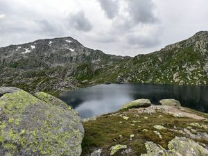
Should be tagged natural=grassland and stones=scree
Should be tagged natural=grassland and stones=bare_rock
Should be tagged only natural=grassland and stones=*
Other combinations with stones=*
Rendering
Also rendering seems quite simple. As only a combination of the current rendering and the rendering of natural=bare_rock and natural=scree has to be created. Furthermore, there is no problem of not rendering it at all, as the main tag of the area is still applied (backward compatible).
For unicolored tags like natural=grassland, landuse=meadow, natural=heath the color should be rendered with the new shader on top of it. With tags like natural=wood, natural=scrub, ... a combination of both shaders must be found.
Shaders for stones=* (first sketch):
Comparison to Osmand natural=fell rendering:
The rendering form Osmand should be extended with the base color of the main key. Grass in render should be removed. For stones=bare_rock also the little dots should be removed, with stones=scree the rocks. For this, the rendering of scrub and trees should be added.
Open questions and problems
- Is the name unique enough? The name could be confused to not be used as a subtag and falsely used as the main tag. Should the name be changed?
- Should the tag only be used alongside natural=grassland, landuse=meadow, natural=heath, natural=scrub, natural=wood and landuse=forest or other tags? Should one of the tags be excluded, because the combination exists too rarely?
- Which render should be used exactly?
Features/Pages affected
A new page for stones=* has to be created out of the proposal.
In the pages of natural=grassland, landuse=meadow, natural=heath, natural=scrub, natural=wood and landuse=forest the subkey has to be added.
Also the pages of natural=fell and natural=tundra should be altered. They should express that these tags are just geographical information and should not be rendered. Furthermore, it should suggest the use of the above tags with the new subkey stones=* if stones are present in the area.
Comments
Please comment on the discussion page.


