Public Transportation Use Cases
| Public Transportation Use Cases | |
|---|---|
| Proposal status: | Inactive (inactive) |
| Proposed by: | JaLooNz |
| Draft started: | 2017-12-31 |
Proposal
This proposal is to document the minimal and recommended features required for public transportation mapping (that is required for rendering and routing) via use cases. This is intended to be a supplement to the Public Transport tagging proposal to clarify what are the minimum mandatory and recommended optional features that should be captured in a route relation, taking into account the ease of maintaining route relations (which can number into thousands for a moderately dense public transport network in a city). This proposal also documents what is in use by various public transport map renderers and what is required for routing calculations to be quickly performed. Information on recent proposals such as Proposed features/PTv2 Improvements wrt Rapid Transit are also included where possible.
Rationale
The current proposals only deals primarily with what features are available for mapping, and does not really describes what each feature is used/can by used by map renderer or routing systems. This results in patchwork of Public Transportation route mapping and causes unnecessary complexity in mapping route relations.
Use Case (with Examples)
Rendering
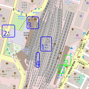
Route relation for Rail (See Blue highlights on images)
| Feature Reference | Feature Tag | Feature Tag (PTv1) | Feature Tag (PTv2) | Renderer | Routing | Comment | Recommendation | ||
|---|---|---|---|---|---|---|---|---|---|
| railway=station | public_transport=station | Yes, role=stop | Yes, as named point. | Yes, as stop. | A single station node representing a station with multiple lines in the immediate vicinity. This station node should not be applied to stop areas as it may differ significantly from the centroid of the stop area. | Mandatory | |||
| railway=rail | Yes, no role | Yes, no role | Yes, as rendered track. | Yes, for calculating distance and traveling time from station-to-station. | Optional (Recommended) | ||||
| public_transport=stop_position | Yes, role=stop | Yes, role=stop | Not used. | Not used. | There is really no need for the stop position beyond this being an optimisation to reduce the calculations of the stop point. | Optional | |||
| highway=platform | public_transport=platform | Yes, role=platform | Yes, role=platform | Yes, as line/area. | Not used. | Optional | |||
| building=train_station | Yes, as building area. | Not used. | This is the station building. Do not apply railway=station or public_transport=station onto the building. | Optional | |||||
| public_transport=stop_area | Not used. | There may be limited use for routing, but needlessly increases the complexity due to increased traversal required. | This captures all elements of a stop. This relation is not useful beyond organisation of stop elements, and to reduce tag duplication especially on multilingual names. Users are recommended to keep important information on the railway=station or public_transport=station tag instead. | Optional |
Routing
Tagging
Applies to
Features/Pages affected
External discussions
Comments
Please comment on the discussion page.

