RU:JOSM/Plugins/Scanaerial
General
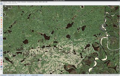
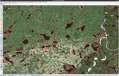
Scanaerial - это пакет с кодом Python для сканирования аэрофотоснимков.
Requirements
- JOSM (current version)
- Ext_tools plug-in for JOSM
- Python & needed libraries (run library_check.py to find out if a library is missing)
- Python Image Library (PIL, in Gentoo: dev-python/imaging). This is only available in Python 2.7 and is not currently available in the newer 3+ versions.
- Python Projection Library (in Gentoo: dev-python/pyproj)
- Current Scanaerial-Script
Setup
Windows
- Разархивируйте архив и поместите его в каталог, который вам нравится (например, C: \ scanaerial \)
- Установите Python, рекомендуется версия 2.7 (в нашем примере это C: \ python27 \)
python-2.7.10.msifor Win32
or
python-2.7.10.amd64.msi for Win64
- ('pil' is already there.)
- Установите необходимые библиотеки Python
- Python Imaging Library (PIL) &
- Python Projection Library (PyProj) (Help see: https://github.com/jswhit/pyproj/issues/13)
pyproj-1.9.5-cp27-none-win32.whl for Win32
or
pyproj-1.9.5-cp27-none-win_amd64.whl for Win64
- Install Ext_tools-Plugin in JOSM (more information on JOSM/Plugins#Installation) & Restart JOSM
- В JOSM нажмите F12 и перейдите в конфигурацию Ext_tools
- Добавьте новый инструмент, нажав кнопку, сказав это. Дайте инструменту хорошее имя (было бы неплохо использовать scanaerial) и вставьте его в командной строке:
C:\python27\python.exe C:\scanaerial\scanaerial.py {lat} {lon} {TZoom}
или если в имени каталога есть пробел (например, C: \ scan aerial \)
C:\python27\python.exe "C:\SCANAE~1\scanaerial.py" {lat} {lon} {TZoom}
использование
C:\python27\python.exe C:\scanaerial\scanaerial.py {lat} {lon}
without {TZoom} to always use Config-File setting fixedzoomlevel. It will create a new menu item in the tools menu.
See also JOSM/Plugins/Scanaerial/Windows
Linux
- Unzip the contents of the downloaded archive to the JOSM Plugin directory. Put it to: ~/.josm/plugins/ext_tools/scanaerial
- Install Python + needed libraries:
- Fedora:
yum install pyproj python-pillow - Ubuntu:
sudo apt-get install python-pyproj python-pil
- Fedora:
- Install Ext_tools-Plugin in JOSM (more information on JOSM/Plugins#Installation) & Restart JOSM
- In JOSM press F12 and go to Ext_tools configuration
- Add a new tool by clicking the button saying so. Give the tool a good name (scanaerial would be an idea) and paste this as commandline:
/home/<username>/.josm/plugins/ext_tools/scanaerial/scanaerial.py {lat} {lon} {TZoom}
It will create a new menu item in the tools menu. (NB: Syntax may change soon. Due to a bug in Ext_tools you can not write “~” instead of “home”)
Если у вас также установлен Python3 в вашей системе, это может быть версия Python по умолчанию, поэтому вы должны добавить интерпретатор Python2 в начале командной строки, например. в Arch
python2 /home/<username>/.josm/plugins/ext_tools/scanaerial/scanaerial.py {lat} {lon} {TZoom}
Использование Scanaerial
- Чтобы вызвать scanaerial, нажмите ctrl k или выберите новый пункт меню. Теперь наведите курсор на область, которую вы хотите отследить, и щелкните левой кнопкой мыши.
- Для лучшего результата вы можете точно настроить значения в scanaerial.cfg
Multiple configurations
Можно настроить Scanaerial для работы с несколькими различными конфигурационными файлами. Для этого создайте отдельный инструмент с разными именами для каждой конфигурации. Имя файла конфигурации передается в качестве четвертого аргумента в scanaerial.py
Пример командной строки:
/home/<username>/.josm/plugins/ext_tools/scanaerial/scanaerial.py {lat} {lon} {TZoom} myconfig1.cfg
Окончательная настройка Config-File
| Key | Default value | Function |
|---|---|---|
| fixedzoomlevel | 11 | use this zoomlevel, if Ext_tools did not tell via TZoom |
| server_api | bing | access method of map server: wms, tms or bing |
| server_name | Bing | name of the map server (only for the tag string) |
| server_url | http://dev.virtualearth.net/... | half-link for WMS, JOSM-like address for TMS |
| empty_tile_bytes | 1033 | size of empty tile (in bytes) for current map server |
| empty_tile_checksum | -332268601 | checksum of empty tile file (algorithm: CRC32) |
| projection | EPSG:3857 | projection that is used on the map server |
| tile_sizex | 256 | leave it to 256 unless you know what you do |
| tile_sizey | 256 | leave it to 256 unless you know what you do |
| douglas_peucker_epsilon | 0.60 | maximum roughness for smoothening the line |
| deactivate_simplifying | 0 | deactivate Douglas-Peucker algorithm (only for debugging) |
| colour_str | 30 | colour sensitivity (depends on contrast of images) |
| maxfilter_setting | 3 | median filter size (noise reduction strength) |
| size_limit | 400 | maximum size of produced object |
Available servers
| server_api = wms
server_name = Landsat server_url = http://irs.gis-lab.info/?layers=landsat& |
| server_api = wms
server_name = OSM |
| server_api = tms
server_name = MapBox empty_tile_bytes = 1882 empty_tile_checksum = -1893505042 |
| server_api = tms
server_name = MapQuest server_url = http://oatile{switch:1,2,3,4}.mqcdn.com/tiles/1.0.0/sat/{zoom}/{x}/{y}.png empty_tile_bytes = 2935 empty_tile_checksum = 839257317 |
| server_api = bing
server_name = Bing empty_tile_bytes = 1033 empty_tile_checksum = -332268601 |
| server_api = tms
server_name = DigitalGlobe |
| server_api = tms
server_name = ESRIWorld server_url = https://{switch:services,server}.arcgisonline.com/arcgis/rest/services/World_Imagery/MapServer/tile/{zoom}/{y}/{x} empty_tile_bytes = 1882 empty_tile_checksum = -1893505042 |
Fan stuff
если вам нравится Scanaerial, вы можете показать другим, что вы используете его, поставив
[[Category:Scanaerial User]]
на вашей странице пользователя.


