Key:building:levels
| Description |
|---|
| The number of above ground levels in a building (if there's only the ground level, this is 1), not including the levels in the roof (use roof:levels to state the number of roof levels). |
| Group: Buildings |
| Used on these elements |
| Requires |
|
building=* or building:part=* |
| Useful combination |
| Status: de facto |
| Tools for this tag |
|
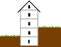
The building:levels tag is used for marking the number of above-ground levels of a building (building=*) or part of a building (building:part=*). The underground levels and the roof do not count as levels here. However, levels that are part-way underground do count (see example below). For the purposes of this tag, "ground level" is defined to be the lowest entrance to a building.
It can be useful to also add height=*, especially if the height per level is different for each building part. Keep in mind that height=* includes the roof, while building:levels does not.
Example
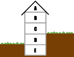
- B + C + D counts as building:levels=3
- E counts as building:levels:underground=1
- A counts as roof:levels=1
Buildings with parts that don't start at ground level
If a building part does not start at the ground level, building:levels=* should include the number of skipped levels below the building part (i.e the number of levels that would exist if the space between the ground and the bottom of the building part were filled with levels of the typical height for this building). The key building:min_level=* should be used to describe the number of skipped levels in this building part.
See Simple 3D Buildings for more information.
Values
Values should be positive numbers. Fractional values (like 1.5) are also valid. They are in common use in 3D tagging. The height of buildings (in meters) is usually difficult to determine if there is no right data, e.g. from a cadastre. The number of levels is a relative value - you know only how many levels a building has and when drawing building:parts, you give their relative number of levels in relation to the whole building.
Rendering examples
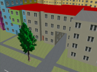
OSMBuildings and OSM2World take this tag into account and render floors as windows.
Accuracy
Note that in many cases it is not entirely clear which exact number should be taken
- basement with large windows (not counted) vs a bit sunken ground level (counted)
Note that if there are two buildings with flat roof next to each other and one has building:levels=5 and one building:levels=4, it is still entirely possible that both have the same height or even that the second one with lower floor count is higher.


